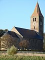
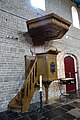
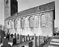
Category:Michaëlskerk (Oosterland)
Jump to navigation
Jump to search
| Object location | | View all coordinates using: OpenStreetMap |
|---|
church building in Hollands Kroon, Netherlands  | |||||
| Upload media | |||||
| Instance of | |||||
|---|---|---|---|---|---|
| Dedicated to | |||||
| Location | Oosterland, North Holland, Den Oever, Hollands Kroon, North Holland, Netherlands | ||||
| Street address |
| ||||
| Has part(s) | |||||
| Heritage designation |
| ||||
| Inception |
| ||||
| Religion or worldview | |||||
| official website | |||||
 | |||||
|
This is a category about rijksmonument number 38933
|
| Address |
|
Subcategories
This category has only the following subcategory.
T
Media in category "Michaëlskerk (Oosterland)"
The following 80 files are in this category, out of 80 total.
-
 Deel van de noordgevel - Den Oever - 20171353 - RCE.jpg 1,200 × 1,173; 318 KB
-
 Detail muurwerk zuid-oost hoek van het interieur - Den Oever - 20175009 - RCE.jpg 1,192 × 1,200; 239 KB
-
 Detail muurwerk zuidgevel, interieur - Den Oever - 20175010 - RCE.jpg 1,192 × 1,200; 236 KB
-
 Detail raam in zuidgevel - Den Oever - 20175004 - RCE.jpg 1,185 × 1,200; 481 KB
-
 Detail venster in zuidgevel, interieur - Den Oever - 20175011 - RCE.jpg 1,190 × 1,200; 306 KB
-
 Detail zuidgevel - Den Oever - 20175000 - RCE.jpg 1,190 × 1,200; 486 KB
-
 Detail zuidgevel - Den Oever - 20175001 - RCE.jpg 1,183 × 1,200; 401 KB
-
 Detail zuidgevel - Den Oever - 20175002 - RCE.jpg 1,192 × 1,200; 480 KB
-
 Easterlân, Michaelstsjerke.jpg 2,232 × 2,506; 2.18 MB
-
 Exterieur KOOR - Den Oever - 20301003 - RCE.jpg 956 × 1,200; 254 KB
-
 Exterieur NOORDGEVEL - Den Oever - 20301001 - RCE.jpg 1,200 × 946; 233 KB
-
 Exterieur OOSTGEVEL - Den Oever - 20301002 - RCE.jpg 958 × 1,200; 246 KB
-
 Exterieur OVERZICHT - Den Oever - 20264755 - RCE.jpg 1,200 × 793; 159 KB
-
 Exterieur OVERZICHT - Den Oever - 20301000 - RCE.jpg 1,198 × 1,200; 378 KB
-
 Exterieur OVERZICHT ZUIDGEVEL, OOSTGEVEL - Den Oever - 20301004 - RCE.jpg 1,182 × 1,200; 292 KB
-
 Exterieur OVERZICHT ZUIDOOST ZIJDE - Den Oever - 20264756 - RCE.jpg 809 × 1,200; 201 KB
-
 Exterieur OVERZICHT ZUIDOOST ZIJDE - Den Oever - 20264757 - RCE.jpg 1,200 × 782; 181 KB
-
 Exterieur van het noord-westen - Den Oever - 20174992 - RCE.jpg 1,200 × 874; 201 KB
-
 Exterieur vernieuwde oostgevel - Den Oever - 20171348 - RCE.jpg 962 × 1,200; 253 KB
-
 Exterieur zijaanzicht - Den Oever - 20171345 - RCE.jpg 962 × 1,200; 235 KB
-
 Exterieur zijaanzicht naar het noord-oosten - Den Oever - 20171344 - RCE.jpg 1,200 × 962; 238 KB
-
 Gedeelte zuidgevel - Den Oever - 20174997 - RCE.jpg 960 × 1,200; 210 KB
-
 Gemetselde doodkist opgesteld in toren (van tufsteen) - Den Oever - 20175022 - RCE.jpg 1,200 × 1,197; 324 KB
-
 Gemetselde doodkist opgesteld in toren (van tufsteen) - Den Oever - 20175023 - RCE.jpg 1,197 × 1,200; 327 KB
-
 Gemetselde torenspits - Den Oever - 20175014 - RCE.jpg 1,197 × 1,200; 255 KB
-
 Gemetselde torenspits - Den Oever - 20175015 - RCE.jpg 1,200 × 1,200; 230 KB
-
 Grafzerk - Den Oever - 20175019 - RCE.jpg 1,200 × 1,200; 502 KB
-
 Grafzerk - Den Oever - 20175020 - RCE.jpg 1,188 × 1,200; 485 KB
-
 Grafzerk - Den Oever - 20175021 - RCE.jpg 1,188 × 1,200; 490 KB
-
 Grafzerken - Den Oever - 20175017 - RCE.jpg 1,200 × 1,192; 383 KB
-
 Grafzerken - Den Oever - 20175018 - RCE.jpg 1,192 × 1,200; 414 KB
-
 Interieur naar het oosten - Den Oever - 20171350 - RCE.jpg 958 × 1,200; 212 KB
-
 Interieur naar het oosten - Den Oever - 20175005 - RCE.jpg 963 × 1,200; 226 KB
-
 Interieur naar het westen - Den Oever - 20171349 - RCE.jpg 1,200 × 962; 218 KB
-
 Interieur naar het westen - Den Oever - 20171351 - RCE.jpg 960 × 1,200; 213 KB
-
 Interieur naar het westen - Den Oever - 20175006 - RCE.jpg 957 × 1,200; 230 KB
-
 Interieur zuid-oost hoek - Den Oever - 20175008 - RCE.jpg 963 × 1,200; 240 KB
-
 Interieur, aanzicht huisorgel, orgelnummer 1146 - Den Oever - 20359342 - RCE.jpg 1,185 × 1,200; 323 KB
-
 INTERIEUR, ORGEL - Den Oever - 20264761 - RCE.jpg 1,200 × 779; 196 KB
-
 INTERIEUR, ORGEL - Den Oever - 20301008 - RCE.jpg 1,193 × 1,200; 393 KB
-
 INTERIEUR, OVERZICHT KOOR - Den Oever - 20301007 - RCE.jpg 1,186 × 1,200; 335 KB
-
 INTERIEUR, OVERZICHT NAAR HET OOSTEN - Den Oever - 20301006 - RCE.jpg 956 × 1,200; 236 KB
-
 INTERIEUR, OVERZICHT NAAR HET WESTEN - Den Oever - 20301005 - RCE.jpg 948 × 1,200; 256 KB
-
 INTERIEUR, PREEKSTOEL - Den Oever - 20301009 - RCE.jpg 1,192 × 1,200; 338 KB
-
 INTERIEUR, RUIMTE ONDER KOOR - Den Oever - 20301012 - RCE.jpg 1,188 × 1,200; 331 KB
-
 INTERIEUR, RUIMTE ONDER KOOR MET STENEN GRAVEN - Den Oever - 20301011 - RCE.jpg 1,185 × 1,200; 365 KB
-
 INTERIEUR, RUIMTE ONDER KOOR, OVERZICHT - Den Oever - 20301010 - RCE.jpg 1,195 × 1,200; 312 KB
-
 Interieur, secretaire-orgel, detail klaviatuur - Den Oever - 20370592 - RCE.jpg 1,200 × 1,200; 236 KB
-
 Kerk Oosterland crypte.jpg 3,648 × 2,736; 4.27 MB
-
 Kerk Oosterland plafond.jpg 2,736 × 3,648; 4.1 MB
-
 Kerk Oosterland sarcofagen in crypte.jpg 2,736 × 3,648; 4.13 MB
-
 Kerk vanuit het noord-westen - Den Oever - 20174991 - RCE.jpg 1,200 × 949; 202 KB
-
 Kerk vanuit het zuid-oosten - Den Oever - 20174990 - RCE.jpg 828 × 1,200; 200 KB
-
 Kerkschip in de Michaëlskerk, Oosterland.jpg 5,472 × 3,648; 6.2 MB
-
 Michaelstsjerke, Easterlân (Wieringen).jpg 3,001 × 1,941; 2.08 MB
-
 Noord-oost gevel - Den Oever - 20175012 - RCE.jpg 953 × 1,200; 255 KB
-
 Noordelijke gevel Michaëlskerk, Oosterland 01.jpg 5,472 × 3,648; 7.92 MB
-
 Noordelijke gevel Michaëlskerk, Oosterland 02.jpg 3,648 × 5,472; 7.84 MB
-
 Noordgevel - Den Oever - 20174998 - RCE.jpg 1,200 × 955; 226 KB
-
 Oosterland (Den Oever) - Michaëlskerk.jpg 3,648 × 2,736; 3.7 MB
-
 Oosterland kerk.jpg 300 × 400; 94 KB
-
 Oostgevel - Den Oever - 20174999 - RCE.jpg 965 × 1,200; 193 KB
-
 Orgel - Den Oever - 20175016 - RCE.jpg 1,200 × 1,195; 332 KB
-
 Oud raam in achterbouw - Den Oever - 20171354 - RCE.jpg 1,195 × 1,200; 463 KB
-
 Overzicht - Den Oever - 20174993 - RCE.jpg 1,200 × 955; 377 KB
-

-
 Plafond in de Michaëlskerk, Oosterland.jpg 5,472 × 3,648; 5.11 MB
-
 Plans en doorsneden naar tekening - Den Oever - 20174988 - RCE.jpg 894 × 1,200; 169 KB
-
 Poortje in de noordgevel - Den Oever - 20171352 - RCE.jpg 1,200 × 1,173; 481 KB
-
 Preekstoel - Den Oever - 20175007 - RCE.jpg 943 × 1,200; 273 KB
-
 Preekstoel in de Michaëlskerk, Oosterland.jpg 3,648 × 5,472; 7.04 MB
-
 Raam in zuidgevel - Den Oever - 20175003 - RCE.jpg 1,188 × 1,200; 398 KB
-
 Reconstructie gemetselde sarcofaag in de Michaëlskerk, Oosterland.jpg 5,472 × 3,648; 7.25 MB
-
 Zicht op Oosterland.jpg 4,896 × 2,034; 461 KB
-
 Zijaanzicht zuidgevel - Den Oever - 20171346 - RCE.jpg 961 × 1,200; 300 KB
-
 Zuid en noordgevel naar tekening - Den Oever - 20174989 - RCE.jpg 1,200 × 897; 195 KB
-
 Zuid-oost gevel - Den Oever - 20174994 - RCE.jpg 1,200 × 953; 197 KB
-
 Zuid-oost zijde toren - Den Oever - 20175013 - RCE.jpg 1,200 × 1,200; 289 KB
-
 Zuidgevel - Den Oever - 20174995 - RCE.jpg 959 × 1,200; 369 KB
-
 Zuidgevel - Den Oever - 20174996 - RCE.jpg 1,200 × 956; 289 KB


_-_Den_Oever_-_20175022_-_RCE.jpg)
_-_Den_Oever_-_20175023_-_RCE.jpg)


.jpg)


_-_Micha%C3%ABlskerk.jpg)


