Category:Methodist Sunday School, Litherland
Jump to navigation
Jump to search
| Object location | | View all coordinates using: OpenStreetMap |
|---|
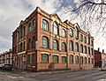
This is a category about listed building number 1283379. |
school building in Sefton, Merseyside, England, UK  | |||||
| Upload media | |||||
| Instance of | |||||
|---|---|---|---|---|---|
| Location | Sefton, Merseyside, North West England, England | ||||
| Heritage designation |
| ||||
 | |||||
Media in category "Methodist Sunday School, Litherland"
The following 4 files are in this category, out of 4 total.
-
 Works dated 1914, Linacre Road - geograph.org.uk - 105663.jpg 640 × 480; 61 KB
-
 Methodist Sunday School, Litherland 1.jpg 4,104 × 3,141; 16.92 MB
-
 Methodist Sunday School, Litherland 2.jpg 6,601 × 3,473; 26.04 MB
-
 Wesleyan Sunday School, Litherland.JPG 4,608 × 3,456; 3.94 MB


