Category:Menhir de Pierrefiche
Jump to navigation
Jump to search
| Object location | | View all coordinates using: OpenStreetMap |
|---|
|
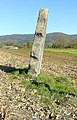
This building is classé au titre des monuments historiques de la France. It is indexed in the base Mérimée, a database of architectural heritage maintained by the French Ministry of Culture, under the reference PA00116580
|
standing stone in Simandre-sur-Suran, France  | |||||
| Upload media | |||||
| Instance of | |||||
|---|---|---|---|---|---|
| Location | Simandre-sur-Suran, Ain, Auvergne-Rhône-Alpes, Metropolitan France, France | ||||
| Heritage designation |
| ||||
| Width |
| ||||
| Length |
| ||||
| Height |
| ||||
| Elevation above sea level |
| ||||
 | |||||
Media in category "Menhir de Pierrefiche"
This category contains only the following file.
-
 Menhir Simandre sur Suran 01-11-2005.jpg 788 × 1,224; 636 KB