Category:Menhir de Men-Bras-de-Kermar-Ker B
Jump to navigation
Jump to search
| Object location | | View all coordinates using: OpenStreetMap |
|---|
 | |||||
| Upload media | |||||
| Instance of | |||||
|---|---|---|---|---|---|
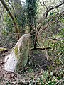
| Location | Moustoir-Ac, canton of Locminé | ||||
| Street address |
| ||||
| Height |
| ||||
 | |||||
Media in category "Menhir de Men-Bras-de-Kermar-Ker B"
The following 4 files are in this category, out of 4 total.
-
 Menhir de Men-Bras-de-Kermar-Ker B 1.jpg 3,120 × 4,160; 8.35 MB
-
 Menhir de Men-Bras-de-Kermar-Ker B 2.jpg 3,120 × 4,160; 8.39 MB
-
 Menhir de Men-Bras-de-Kermar-Ker B 3.jpg 3,120 × 4,160; 6.18 MB
-
 Menhir de Men-Bras-de-Kermar-Ker B 4.jpg 3,120 × 4,160; 7.92 MB


