Category:Mendelkamm
Jump to navigation
Jump to search
Deutsch: Der Mendelkamm ist eine Gebirgskette der Nonsberggruppe in Südtirol.
English: The Mendelkamm is a mountain range of the Nonsberg group in South Tyrol.
mountain range  | |||||
| Upload media | |||||
| Instance of |
| ||||
|---|---|---|---|---|---|
| Location |
| ||||
| Mountain range | |||||
| Highest point | |||||
 | |||||
Subcategories
This category has the following 7 subcategories, out of 7 total.
C
- Cima Roccapiana (1 P, 15 F)
F
G
- Gantkofel (Mendelkamm) (1 P, 35 F)
- Göller - Col di Sotto (1 P, 8 F)
P
R
T
- Tresner Horn (10 F)
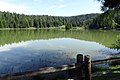
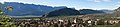
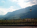
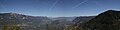
Media in category "Mendelkamm"
The following 61 files are in this category, out of 61 total.
-
 002 - Transetto alla metà del ponte.jpg 4,635 × 6,947; 4.51 MB
-
 04 Tretboote.jpg 3,264 × 2,448; 3.9 MB
-
 20.158Bozen,Mendelkamm.JPG 1,024 × 768; 187 KB
-
 2011-04-07 15-52-11 Italy Trentino-Alto Adige Castelvecchio.jpg 14,262 × 2,328; 10.83 MB
-
 Alto Adige - Süd Tirol - Ora - Auer - Via Nazionale - April 2010 02.jpg 3,024 × 2,016; 3.12 MB
-
 Am Felixweiher.jpg 5,184 × 3,456; 3.78 MB
-
 Auer - Katzenleiter - Panorama nach NW.jpg 13,012 × 2,942; 8.38 MB
-
 Banco e Casez e Malgolo - panorama - 01.jpg 640 × 480; 112 KB
-
 Blick von der Paganella 2019-08-30.jpg 3,648 × 2,736; 5.11 MB
-

-
 Bozen Etschtal Furgglauerscharte sw PICT0023 199904.jpg 2,520 × 1,680; 956 KB
-
 Bozen gegen die Mendel.jpg 4,306 × 2,732; 5.65 MB
-
 Brez, Novella.jpg 3,164 × 1,895; 3.66 MB
-
 Brunnenburg gegen Mendel im Herbst.jpg 3,456 × 2,304; 3.44 MB
-
 Cagnò-S.jpg 2,588 × 1,456; 1.77 MB
-
 Castelfeder-Panorama1.jpg 1,024 × 275; 83 KB
-
 Cles. NYPL1226749.tiff 5,195 × 4,352; 53.16 MB
-
 Cordigliera della Mendola.jpg 1,600 × 1,200; 170 KB
-
 Dorfvonoben2.jpg 1,632 × 1,232; 725 KB
-
 Felixweiher.jpg 3,456 × 2,304; 2.43 MB
-
 Gschnon Kanzel 3.jpg 12,817 × 3,253; 8.14 MB
-
 ISS041-E-104170 - View of Switzerland.jpg 4,928 × 3,280; 2.8 MB
-
 Kalterer See (3D Südtirol).jpg 10,844 × 5,422; 23.57 MB
-
 Kalterer See - Panorama gegen die Mendelkette.jpg 10,614 × 3,098; 10.11 MB
-
 Kalterer See von Kreit.jpg 3,648 × 2,736; 3.22 MB
-
 Kaltern mit Mendelpass.jpg 3,264 × 2,448; 3.62 MB
-
 Kaltern, Mendelpass und Mendelbahn.jpg 3,264 × 2,448; 3.79 MB
-
 Karnol Leiterburg 9.JPG 3,264 × 2,448; 3.7 MB
-
 Kurtatsch von Pinzon.JPG 3,264 × 2,448; 3.41 MB
-
 KurtatschfromMazon.JPG 3,264 × 2,448; 2.78 MB
-
 Lago di Santa Giustina da Maiano 02.jpg 2,256 × 856; 1,005 KB
-
 LagoDiCaldaro-vistoDallaMendola-small.jpg 500 × 292; 23 KB
-
 Lana Südtirol Panorama 3.jpg 6,648 × 2,177; 11.15 MB
-
 Mendelkamm ober Graun.JPG 3,264 × 2,448; 4.17 MB
-
 Mendelkamm2.JPG 3,264 × 2,448; 4.33 MB
-
 Mezzocorona - panorama.jpg 6,142 × 3,408; 4.49 MB
-
 Mitterberg von der Dolomitenstraße - 01.jpg 6,609 × 3,085; 4.28 MB
-
 Naunia 1829 carta geografica.png 7,551 × 5,361; 11.45 MB
-
 Nonstal von Spormaggiore aus gesehen.jpg 3,264 × 1,469; 1.81 MB
-
 Northern Mendelkamm and Texelgruppe.JPG 3,264 × 2,448; 2.79 MB
-
 Northern Mendelkamm.JPG 3,264 × 2,448; 2.73 MB
-
 Penegal Kulm 1908.png 1,086 × 1,778; 155 KB
-
 Revò.jpg 3,200 × 1,824; 2.5 MB
-
 S. Giustina Lake, Cles, Val di Non.jpg 4,928 × 3,264; 9.25 MB
-
 Schönegg Mendelkamm (1).jpg 4,032 × 3,024; 6.2 MB
-
 Schönegg Mendelkamm (2).jpg 5,184 × 3,456; 11.71 MB
-
 Schönegg Mendelkamm (3).jpg 5,184 × 3,456; 11.69 MB
-
 Schönegg Mendelkamm (4).jpg 5,184 × 3,456; 10.62 MB
-
 Sfruz- panorama.jpg 4,288 × 2,848; 5.26 MB
-
 Southern Mitterberg as seen from Auer.JPG 3,264 × 2,448; 3.55 MB
-
 St. Vigil - Altenburg - Mendelkamm - vom Kalterer See.jpg 5,184 × 3,456; 5.48 MB
-
 Tassullo - Panorama.jpg 4,426 × 2,794; 9.41 MB
-
 Trento-panorama rifugio Maranza.jpg 4,923 × 1,489; 3.16 MB
-
 Truden - Hochwandweg - 01.jpg 5,184 × 3,456; 4.39 MB
-
 Tuenno by drone.jpg 3,840 × 2,160; 4 MB
-
 Val di Non - Rifugio Peller.jpg 1,600 × 1,200; 356 KB
-
 Val di Non da Baselga.jpg 3,798 × 2,536; 4.64 MB
-
 Valle Adige.jpg 2,048 × 1,536; 1.86 MB
-
 Valle dell'Adige.jpg 3,900 × 2,925; 5.04 MB
-
 Vigiljoch von der Mutspitze.JPG 3,264 × 2,448; 3.4 MB
-
 Wv Tassullo banner.jpg 4,077 × 583; 1.76 MB


.jpg)


.jpg)
.jpg)
.jpg)
.jpg)


