Category:Meierturm (Klausenstrasse, Bürglen)
Jump to navigation
Jump to search
| Object location | | View all coordinates using: OpenStreetMap |
|---|
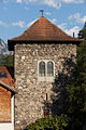
stone tower in Bürglen in the canton of Uri, Switzerland  | |||||
| Upload media | |||||
| Instance of | |||||
|---|---|---|---|---|---|
| Part of | |||||
| Location | Bürglen, Uri, Switzerland | ||||
| Street address |
| ||||
| Heritage designation | |||||
 | |||||
Media in category "Meierturm (Klausenstrasse, Bürglen)"
The following 3 files are in this category, out of 3 total.
-
 B-Buerglen-UR-Meierturm.jpg 800 × 1,200; 1.21 MB
-
 Buerglen-UR-Meierturm.jpg 800 × 1,200; 1.31 MB
-
 Bürglen Meierturm und Tell.jpg 820 × 560; 163 KB

