Category:Megget Water
Jump to navigation
Jump to search

Media in category "Megget Water"
The following 18 files are in this category, out of 18 total.
-
 Delta of the Megget Water - geograph.org.uk - 1542746.jpg 640 × 480; 77 KB
-
 Megget Water - geograph.org.uk - 1328243.jpg 640 × 480; 106 KB
-
 Megget Water - geograph.org.uk - 969757.jpg 640 × 359; 94 KB
-
 Megget Water - geograph.org.uk - 973899.jpg 640 × 359; 95 KB
-
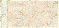 Ordnance Survey Sheet NT 22 32 Yarrow, Published 1967.jpg 14,788 × 6,998; 40.96 MB
-
-
 Sheep fank, Meggethead - geograph.org.uk - 973893.jpg 640 × 359; 86 KB
-
 St. Mary's Loch and Megget Reservoir from a plane.JPG 2,688 × 2,052; 4.24 MB
-
 The Megget Water 'delta' - geograph.org.uk - 1292480.jpg 640 × 480; 79 KB
-
 The Megget Water at Cappercleuch - geograph.org.uk - 1292463.jpg 640 × 480; 103 KB
-
 The Megget Water at Cappercleuch - geograph.org.uk - 1292483.jpg 640 × 480; 85 KB
-
 The Megget Water at Cappercleuch - geograph.org.uk - 1542736.jpg 480 × 640; 137 KB
-
 The Megget Water at Glengaber - geograph.org.uk - 1108469.jpg 640 × 427; 121 KB
-

-
 Megget Water and Megget Reservoir - geograph.org.uk - 182452.jpg 640 × 438; 191 KB
-
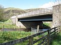
 Talla to Megget road - geograph.org.uk - 320121.jpg 640 × 480; 74 KB
-
 The Megget Water, near Cappercleuch. - geograph.org.uk - 324427.jpg 640 × 480; 98 KB
-


