Category:Medway Valley Line
Jump to navigation
Jump to search
The Medway Valley Line is the name given to the railway line linking Strood and the Medway Towns with Maidstone West and onward to Paddock Wood and Tonbridge.
Railway line in Kent  | |||||
| Upload media | |||||
| Instance of | |||||
|---|---|---|---|---|---|
| Part of |
| ||||
| Location | Kent, South East England, England | ||||
| Connects with | |||||
| Owned by | |||||
| Has part(s) |
| ||||
| Date of official opening |
| ||||
| |||||
Subcategories
This category has the following 16 subcategories, out of 16 total.
A
B
- Beltring railway station (17 F)
C
E
- East Farleigh railway station (43 F)
H
- Halling railway station (11 F)
M
N
- New Hythe railway station (6 F)
P
S
- Strood railway station (98 F)
T
- Teston level crossing (6 F)
W
Y
- Yalding railway station (23 F)
Media in category "Medway Valley Line"
The following 16 files are in this category, out of 16 total.
-
 Bridge in the trees - geograph.org.uk - 2740119.jpg 640 × 430; 128 KB
-
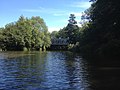 Canoe view of the River Medway - geograph.org.uk - 4606246.jpg 640 × 480; 70 KB
-
 MaidstoneBarracksStn0052.JPG 2,048 × 1,536; 787 KB
-

-

-
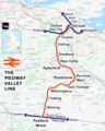 Medway Valley line.png 1,362 × 1,701; 1.56 MB
-
 Rail-over-rail bridge, Maidstone - geograph.org.uk - 779481.jpg 640 × 480; 87 KB
-
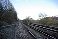 Railway near Nettlestead Church - geograph.org.uk - 331644.jpg 640 × 428; 105 KB
-

-
 Railway to Halling - geograph.org.uk - 1084228.jpg 481 × 640; 59 KB
-
 Railway to Yalding - geograph.org.uk - 1231824.jpg 640 × 480; 119 KB
-
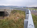 Roundabout on A228 Halling By-Pass - geograph.org.uk - 1084224.jpg 640 × 481; 79 KB
-
 Station Road level crossing, Aylesford 01.jpg 5,152 × 3,864; 4.24 MB
-
 Station Road level crossing, Aylesford 02.jpg 5,152 × 3,864; 4.44 MB
-
 Steam on the Medway Valley Line - geograph.org.uk - 1609847.jpg 640 × 427; 98 KB
-


