Category:McClellan–Kerr Arkansas River Navigation System
Jump to navigation
Jump to search
part of the inland waterway system originating at the Tulsa Port of Catoosa and running southeast through Oklahoma and Arkansas to the Mississippi River | |||||
| Upload media | |||||
| Location |
| ||||
|---|---|---|---|---|---|
 | |||||
Subcategories
This category has the following 2 subcategories, out of 2 total.
L
- Lake Dardanelle (9 F)
R
Media in category "McClellan–Kerr Arkansas River Navigation System"
The following 14 files are in this category, out of 14 total.
-
 Aerial photo of the Tulsa Port of Catoosa taken May 5, 2008.jpg 3,000 × 2,397; 5.78 MB
-
 Big Dam Bridge.jpg 2,144 × 1,424; 848 KB
-
 CAC CC 001 18 34 0000 3322a.jpg 788 × 522; 44 KB
-
 CAC CC 001 18 34 0000 3322b.jpg 788 × 522; 48 KB
-
 CAC CC 001 18 34 0000 3322c.jpg 788 × 522; 47 KB
-
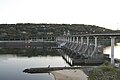
 Joe Hardin Lock and Dam, Arkansas River.jpg 4,928 × 3,264; 9.15 MB
-
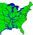 Kerr-McClellan map.png 500 × 541; 250 KB
-
 Map of McClellan–Kerr Arkansas River Navigation System.jpg 1,064 × 656; 234 KB
-
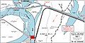 McClellan–Kerr Arkansas River Navigation System, Pool 2, Navigation Chart.jpg 1,491 × 760; 428 KB
-
 Murray Lock.jpg 2,144 × 1,424; 707 KB
-
 Norrell Lock and Dam, Arkansas.jpg 4,928 × 2,693; 8.01 MB
-
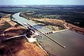 USACE Newt Graham Lock and Dam.jpg 1,500 × 999; 537 KB
-
 USACE Webbers Falls Lock and Dam.jpg 1,001 × 1,500; 580 KB
-
 Wilbur D. Mills Dam.jpg 4,928 × 2,637; 8.85 MB


