Category:May 2020 in Washington (state)
Jump to navigation
Jump to search
English: Images/pictures taken in Washington (state) during May 2020. Note this is not the date of the upload, nor the date a photo was scanned.
States of the United States: Alabama · Alaska · Arizona · Arkansas · California · Colorado · Connecticut · Delaware · Florida · Georgia · Hawaii · Idaho · Illinois · Indiana · Iowa · Kansas · Kentucky · Louisiana · Maryland · Massachusetts · Michigan · Minnesota · Missouri · Montana · Nevada · New Jersey · New Mexico · New York · North Carolina · North Dakota · Ohio · Oklahoma · Oregon · Pennsylvania · Rhode Island · South Carolina · Tennessee · Texas · Utah · Virginia · Washington · West Virginia · Wisconsin · Wyoming – Washington, D.C.
| May 2019 | ← | May 2020 | → | May 2021 | |||||||||
| Jan | Feb | Mar | Apr | May | Jun | Jul | Aug | Sep | Oct | Nov | Dec | ||
| ← | 20 | 103 | 74 | 92 | 511 | 313 | 126 | 176 | 56 | 310 | 102 | 27 | → |
|---|---|---|---|---|---|---|---|---|---|---|---|---|---|
Subcategories
This category has the following 2 subcategories, out of 2 total.
G
S
Media in category "May 2020 in Washington (state)"
The following 200 files are in this category, out of 509 total.
(previous page) (next page)-
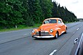 1947 Chevrolet spotted on Interstate 5 in Snohomish County, WA 2020-05-23.jpg 6,000 × 4,000; 10.23 MB
-
 2020-05-31, Pediatric Interim Care Center, Kent, Washington, 01.jpg 4,032 × 3,024; 4.16 MB
-
 2020-05-31, Pediatric Interim Care Center, Kent, Washington, 02.jpg 4,032 × 3,024; 3.93 MB
-
 2020-05-31, Pediatric Interim Care Center, Kent, Washington, 03.jpg 4,032 × 3,024; 4.31 MB
-
 2020-05-31, Pediatric Interim Care Center, Kent, Washington, 04.jpg 4,032 × 3,024; 3.57 MB
-
 2020-05-31, Pediatric Interim Care Center, Kent, Washington, 05.jpg 4,032 × 3,024; 3.52 MB
-
 Allen Library breezeway 01.jpg 6,000 × 4,000; 9.77 MB
-
 Approaching Cecil Moses Memorial Park from the north 01.jpg 6,000 × 4,000; 11.85 MB
-
 Approaching Cecil Moses Memorial Park from the north 02.jpg 6,000 × 4,000; 14 MB
-
 Approaching Cecil Moses Memorial Park from the north 03.jpg 6,000 × 4,000; 10.01 MB
-
 Approaching the portico of the Washington State Capitol.jpg 4,000 × 6,000; 10.65 MB
-
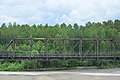 Arlington, WA - rail bridge over the Stillaguamish River.jpg 6,000 × 4,000; 11.17 MB
-
 Auburn, WA - Canada Goose on the bank of the Green River.jpg 6,000 × 4,000; 10.42 MB
-
 Auburn, WA - gull flying low over the Green River 01.jpg 1,553 × 1,136; 1.08 MB
-
 Auburn, WA - gull flying low over the Green River 02.jpg 1,808 × 1,352; 1.33 MB
-
 Auburn, WA - gull landing on the Green River 01 (cropped).jpg 1,134 × 457; 369 KB
-
 Auburn, WA - gull landing on the Green River 01.jpg 1,791 × 1,180; 1.22 MB
-
 Auburn, Washington - Auburn Golf Course & Bogie's Public House - sign.jpg 6,000 × 4,000; 11.13 MB
-
 Auburn, Washington - Auburn Golf Course & Bogie's Public House 01.jpg 6,000 × 4,000; 12.82 MB
-
 Auburn, Washington - Auburn Golf Course & Bogie's Public House 02.jpg 6,000 × 4,000; 11.66 MB
-
 Auburn, Washington - downriver from suspension bridge in Isaac Evans Park 02.jpg 6,000 × 4,000; 13.51 MB
-
 Auburn, Washington - Dykstra Park - bridge to Isaac Evans Park 01.jpg 6,000 × 4,000; 13.62 MB
-
 Auburn, Washington - Dykstra Park 01.jpg 6,000 × 4,000; 13.49 MB
-
 Auburn, Washington - Isaac Evans Park 03.jpg 6,000 × 4,000; 12.29 MB
-
 Auburn, Washington - man with bicycle seen across Green River from Isaac Evans Park 01.jpg 6,000 × 4,000; 12.59 MB
-
 Auburn, Washington - path just east of Green River in Isaac Evans Park 01.jpg 6,000 × 4,000; 13.45 MB
-
 Auburn, Washington - path just east of Green River in Isaac Evans Park 02.jpg 4,000 × 6,000; 13.5 MB
-

-
 Auburn, Washington - power lines perpendicular to Green River Road SE - 01.jpg 4,000 × 6,000; 9.28 MB
-
 Auburn, Washington - power lines perpendicular to Green River Road SE - 02.jpg 6,000 × 4,000; 12.05 MB
-
 Auburn, Washington - power lines perpendicular to Green River Road SE - 03.jpg 6,000 × 4,000; 11.59 MB
-
 Auburn, Washington - power lines perpendicular to Green River Road SE - 04.jpg 6,000 × 4,000; 9 MB
-
 Auburn, Washington - power lines perpendicular to Green River Road SE - 05.jpg 6,000 × 4,000; 9.11 MB
-
 Auburn, Washington - power lines perpendicular to Green River Road SE - 06.jpg 6,000 × 4,000; 12.74 MB
-
 Auburn, Washington - small beach on Green River in Isaac Evans Park 01.jpg 6,000 × 4,000; 13.91 MB
-
 Auburn, Washington - suspension bridge in Isaac Evans Park 04.jpg 4,000 × 6,000; 13.73 MB
-
 Auburn, Washington - suspension bridge in Isaac Evans Park 05.jpg 6,000 × 4,000; 13.75 MB
-
 Auburn, Washington - upriver from suspension bridge in Isaac Evans Park 02.jpg 6,000 × 4,000; 13.63 MB
-

-

-
 Bridge at North Wind's Weir 02.jpg 6,000 × 4,000; 13.72 MB
-
 Bridge at North Wind's Weir 03.jpg 6,000 × 4,000; 13.48 MB
-
 Bridge at North Wind's Weir from the west 01.jpg 6,000 × 4,000; 14.47 MB
-
 Buildings seen on hillside from Green River Trail near S 112th Street in Tukwila, WA 01.jpg 6,000 × 4,000; 12.21 MB
-
 Canada Geese fighting near North Wind's Weir 01.jpg 6,000 × 4,000; 11.58 MB
-
 Canada Geese fighting near North Wind's Weir 02.jpg 6,000 × 4,000; 12.14 MB
-
 Canada Geese fighting near North Wind's Weir 03.jpg 6,000 × 4,000; 12 MB
-
 Canada Geese fighting near North Wind's Weir 04.jpg 6,000 × 4,000; 12.22 MB
-
 Canada Geese near North Wind's Weir 01.jpg 6,000 × 4,000; 12.66 MB
-
 Canada Geese near North Wind's Weir 02.jpg 6,000 × 4,000; 11.42 MB
-
 Canada Geese near North Wind's Weir 03.jpg 6,000 × 4,000; 12.2 MB
-
 Canada Geese near North Wind's Weir 04.jpg 6,000 × 4,000; 9.06 MB
-
 Canada Geese near North Wind's Weir 05.jpg 6,000 × 4,000; 10.03 MB
-
 Canada Geese near North Wind's Weir 06.jpg 6,000 × 4,000; 9.14 MB
-
 Canada Geese near North Wind's Weir 07.jpg 6,000 × 4,000; 12.94 MB
-
Canada Geese swimming near North Wind's Weir.webm 26 s, 1,920 × 1,080; 20.16 MB
-
 Cecil Moses Memorial Park from footbridge - 2020-05-17 - 01.jpg 6,000 × 4,000; 13.24 MB
-
 Cecil Moses Memorial Park from footbridge - 2020-05-17 - 02.jpg 6,000 × 4,000; 13.82 MB
-
 Clear Lake, Washington - elementary school 01.jpg 6,000 × 4,000; 9.64 MB
-
 Clear Lake, Washington - Evelyn's Tavern.jpg 6,000 × 3,616; 8.16 MB
-
 Clear Lake, Washington - northbound on Washington State Route 9.jpg 6,000 × 3,384; 8.88 MB
-
 Deming, WA - American Legion Post 83.jpg 6,000 × 4,000; 13.53 MB
-
 Deming, WA - Mount Baker Junior High School.jpg 6,000 × 4,000; 10.84 MB
-
 Deming, WA - Mount Baker school & playfields.jpg 4,636 × 2,288; 4.92 MB
-
 Deming, WA - Nooksack Indian Tribe Office Building - signs during COVID-19 outbreak.jpg 6,000 × 4,000; 9.53 MB
-
 Deming, WA - Nooksack Indian Tribe Office Building 01.jpg 6,000 × 4,000; 12.54 MB
-
 Deming, WA - Nooksack Indian Tribe Office Building 02.jpg 6,000 × 4,000; 12.35 MB
-
 Deming, WA - Nooksack Indian Tribe Office Building 03.jpg 6,000 × 4,000; 9.88 MB
-
 Deming, WA - Nooksack Market.jpg 6,000 × 4,000; 8.86 MB
-
 Deming, WA - Nooksack River Casino 01.jpg 6,000 × 4,000; 10.32 MB
-
 Deming, WA - Nooksack River Casino 02.jpg 6,000 × 4,000; 11.28 MB
-
 Downtown Tacoma, Washington from Interstate 5 - 01.jpg 5,800 × 2,471; 5.49 MB
-
 Duck and duckling swimming east of North Wind's Weir 01.jpg 6,000 × 4,000; 11.42 MB
-
 Duck swimming east of North Wind's Weir 01.jpg 6,000 × 4,000; 9.39 MB
-
 Duck swimming east of North Wind's Weir 02.jpg 6,000 × 4,000; 11.17 MB
-
 Duck swimming east of North Wind's Weir 03.jpg 6,000 × 4,000; 8.5 MB
-
 Duck swimming east of North Wind's Weir 04.jpg 6,000 × 4,000; 8.4 MB
-
 Duck swimming east of North Wind's Weir 05.jpg 6,000 × 4,000; 9.4 MB
-
 Duck swimming east of North Wind's Weir.jpg 6,000 × 4,000; 10.21 MB
-
 Duckling swimming east of North Wind's Weir 01.jpg 6,000 × 4,000; 9.15 MB
-
 Duwamish River - geese graze on North Wind's Weir.jpg 6,000 × 4,000; 11.77 MB
-
 Duwamish River - looking downriver past North Wind's Weir 01.jpg 6,000 × 4,000; 11.78 MB
-
 Duwamish River - looking downriver past North Wind's Weir 02.jpg 6,000 × 4,000; 13.4 MB
-
 Duwamish River - looking downriver past North Wind's Weir 03.jpg 6,000 × 4,000; 13.51 MB
-
 Duwamish River - looking downriver past North Wind's Weir 04.jpg 6,000 × 4,000; 10.5 MB
-
 Duwamish River - north and east of North Wind's Weir at low tide 01.jpg 6,000 × 4,000; 13.41 MB
-
 Duwamish River - north of North Wind's Weir at low tide 01.jpg 6,000 × 4,000; 13.8 MB
-
 Duwamish River - North Wind's Weir 03.jpg 6,000 × 4,000; 12.3 MB
-
 Duwamish River - North Wind's Weir 04.jpg 6,000 × 4,000; 11.53 MB
-
 Duwamish River - North Wind's Weir 05.jpg 6,000 × 4,000; 11.24 MB
-
 Duwamish River - North Wind's Weir detail 01.jpg 6,000 × 4,000; 13.41 MB
-
 Duwamish River - North Wind's Weir from Cecil Moses Memorial Park 01.jpg 6,000 × 4,000; 10.76 MB
-
 Duwamish River Turning Basin 02.jpg 6,000 × 4,000; 14 MB
-
 Duwamish River Turning Basin 03.jpg 6,000 × 4,000; 11.67 MB
-
 Duwamish River Turning Basin and S 98th Street Bridge 01.jpg 6,000 × 4,000; 13.8 MB
-
 Duwamish River Turning Basin and S 98th Street Bridge 02.jpg 6,000 × 4,000; 13.06 MB
-
 Duwamish Turning Basin and Seattle skyline 2020-05-27 - 01.jpg 6,000 × 4,000; 11.1 MB
-
 Duwamish Turning Basin and Seattle skyline 2020-05-27 - 02.jpg 6,000 × 4,000; 11.57 MB
-
 Enumclaw, WA — Farmers Park (2020-05-17), 01.jpg 4,032 × 3,024; 5.42 MB
-
 Enumclaw, WA — Farmers Park (2020-05-17), 02.jpg 3,024 × 4,032; 6.11 MB
-
 Enumclaw, WA — Farmers Park (2020-05-17), 03.jpg 4,032 × 3,024; 4.88 MB
-
 Enumclaw, WA — Farmers Park (2020-05-17), 04.jpg 3,024 × 4,032; 4.78 MB
-
 Enumclaw, WA — Farmers Park (2020-05-17), 05.jpg 3,024 × 4,032; 4.36 MB
-
 Enumclaw, WA — Farmers Park (2020-05-17), 06.jpg 3,024 × 4,032; 5.78 MB
-
 Enumclaw, WA — Farmers Park (2020-05-17), 07.jpg 3,024 × 4,032; 3.54 MB
-
 Enumclaw, WA — Farmers Park (2020-05-17), 08.jpg 3,024 × 4,032; 3.59 MB
-
 Enumclaw, WA — Farmers Park (2020-05-17), pano.jpg 15,488 × 3,898; 21.46 MB
-
 Enumclaw, WA — Stop N Shop, grocery store (2020-05-17), 01.jpg 4,032 × 3,024; 2.54 MB
-
 Enumclaw, WA — Stop N Shop, grocery store (2020-05-17), 02.jpg 4,032 × 3,024; 2.62 MB
-
 Enumclaw, WA — Stop N Shop, grocery store (2020-05-17), 03.jpg 4,032 × 3,024; 2.63 MB
-
 Enumclaw, WA — Stop N Shop, grocery store (2020-05-17), 04.jpg 4,032 × 3,024; 2.84 MB
-
 Everett, WA - Dagmar's Marina from Interstate 5 - 01.jpg 6,000 × 4,000; 7.44 MB
-
 Everett, WA - Snohomish River looking east from Interstate 5 - 01.jpg 6,000 × 3,584; 6.69 MB
-
 Everett, WA - Steamboat Slough looking east from Interstate 5 - 01.jpg 5,723 × 2,968; 5.82 MB
-
 Everett, WA - Steamboat Slough looking east from Interstate 5 - 02.jpg 5,810 × 2,211; 4.56 MB
-
 Everett, WA - Union Slough looking east from Interstate 5 - 01.jpg 5,713 × 2,802; 6.03 MB
-
 Everett, WA - Union Slough looking west from Interstate 5 - 01.jpg 6,000 × 4,000; 7.78 MB
-
 Everett, WA - Union Slough looking west from Interstate 5 - 02.jpg 6,000 × 4,000; 6.48 MB
-
 Everett, WA - Union Slough looking west from Interstate 5 - 03.jpg 5,895 × 2,782; 5.48 MB
-
 Fishing from North Wind's Weir 01.jpg 6,000 × 4,000; 14.12 MB
-
 Fishing from North Wind's Weir 02.jpg 6,000 × 4,000; 12.98 MB
-
 Fishing from North Wind's Weir 03.jpg 6,000 × 4,000; 14.52 MB
-
 Fishing from North Wind's Weir 04.jpg 6,000 × 4,000; 13.58 MB
-
 Fishing in the Duwamish from Cecil Moses Memorial Park 2020-05-17.jpg 6,000 × 4,000; 13.42 MB
-
 Great Blue Heron near North Wind's Weir 01 (cropped).jpg 1,252 × 1,871; 1.27 MB
-
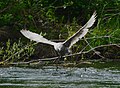
 Great Blue Heron near North Wind's Weir 01.jpg 6,000 × 4,000; 11.13 MB
-
 Green River Trail sign near S 102nd Street in Tukwila, WA 01.jpg 6,000 × 4,000; 10.51 MB
-
 Heron at North Wind's Weir 01 - from Cecil Moses Memorial Park.jpg 6,000 × 4,000; 9.93 MB
-
 Heron at North Wind's Weir 02.jpg 6,000 × 4,000; 9.8 MB
-
 Heron at North Wind's Weir 03.jpg 6,000 × 4,000; 10.27 MB
-
 Heron at North Wind's Weir 04.jpg 6,000 × 4,000; 10.25 MB
-
 Heron at North Wind's Weir 05.jpg 6,000 × 4,000; 9.63 MB
-
 Heron at North Wind's Weir 06.jpg 6,000 × 4,000; 10.97 MB
-
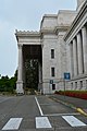
 Insurance Building from portico of Washington State Capitol.jpg 6,000 × 4,000; 8.32 MB
-
 Interstate 5 bridge over Nisqually River 03.jpg 6,000 × 4,000; 9.4 MB
-
 Interstate 5 bridge over Nisqually River 04.jpg 6,000 × 4,000; 9.14 MB
-
 Interstate 5 southbound - Stillaguamish River bridge.jpg 6,000 × 4,000; 8.83 MB
-
 Interstate 5 southbound, south of Bellingham, WA near Lake Padden 01.jpg 6,000 × 4,000; 10.27 MB
-
 Interstate 5 southbound, south of Bellingham, WA near Lake Padden 02.jpg 6,000 × 4,000; 11.08 MB
-
 Irv Newhouse Building 01.jpg 6,000 × 4,000; 13.51 MB
-
Isaac Evans Park - Seagull on rock in Green River.webm 8.7 s, 1,920 × 1,080; 17.74 MB
-
 Joel M. Pritchard Building from Washington State Capitol portico on a rainy day.jpg 6,000 × 4,000; 10.81 MB
-
 Joel M. Pritchard Building from Washington State Capitol portico.jpg 6,000 × 4,000; 10.04 MB
-
 Joel M. Pritchard Building on a rainy day.jpg 6,000 × 4,000; 12.27 MB
-

-
 Kent, WA — Kent Lutheran Church (2020-05-31), 01.jpg 3,024 × 4,032; 3.19 MB
-
 Kent, WA — Kent Lutheran Church (2020-05-31), 02.jpg 4,032 × 3,024; 3.73 MB
-
 Kent, WA — Kent Valley ECEAP (2020-05-31), 01.jpg 3,805 × 2,530; 2.4 MB
-
 Kent, WA — Kent Valley ECEAP (2020-05-31), 02.jpg 3,490 × 2,617; 6.71 MB
-
 Kent, WA — Montessori Plus School Downtown Kent Campus (2020-05-31).jpg 4,032 × 3,024; 2.76 MB
-
 Kent, WA — St. Anthony Chapel (2020-05-31), 01.jpg 3,024 × 4,032; 2.15 MB
-
 Kent, WA — St. Anthony Chapel (2020-05-31), 02, edit.jpg 3,024 × 4,032; 12.02 MB
-
 Kent, WA — St. Anthony Chapel (2020-05-31), 02.jpg 3,024 × 4,032; 2.32 MB
-
 Kent, WA — St. Anthony Chapel (2020-05-31), 03.jpg 3,024 × 4,032; 2.72 MB
-
 Kent, WA — St. Anthony Chapel (2020-05-31), 04.jpg 4,032 × 3,024; 2.5 MB
-
 Kent, WA — St. Anthony Chapel (2020-05-31), 05.jpg 4,032 × 3,024; 2.61 MB
-
 Kent, WA — St. Anthony Chapel (2020-05-31), 06.jpg 4,032 × 3,024; 2.58 MB
-
 Lake Tapps from looking south from Causeway Rd E (2020-05-01).jpg 4,032 × 3,024; 2.52 MB
-
 Link Light Rail crosses the Duwamish 02.jpg 6,000 × 4,000; 10.88 MB
-
 Link Light Rail crosses the Duwamish 03.jpg 6,000 × 4,000; 13.97 MB
-
 Link Light Rail crosses the Duwamish 04.jpg 6,000 × 4,000; 12.85 MB
-
 Midget racer being transported on Interstate 5 in Snohomish County, WA 01.jpg 6,000 × 4,000; 9.7 MB
-

-
 Midget racer being transported on Interstate 5 in Snohomish County, WA 02.jpg 6,000 × 4,000; 7.89 MB
-
 Mount Rainier from Green River Trail near S 102nd Street in Tukwila, WA 01.jpg 6,000 × 4,000; 12.91 MB
-
 Mount Rainier from Green River Trail near S 102nd Street in Tukwila, WA 02.jpg 6,000 × 4,000; 10.78 MB
-
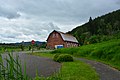
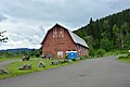
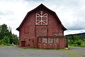
 Nakashima Heritage Barn - detail 01.jpg 6,000 × 4,000; 12.95 MB
-
 Nakashima Heritage Barn - trailhead sign.jpg 6,000 × 4,000; 13.38 MB
-
 Nakashima Heritage Barn 01.jpg 4,544 × 3,080; 5.48 MB
-
 Nakashima Heritage Barn 02.jpg 6,000 × 4,000; 12.01 MB
-
 Nakashima Heritage Barn 03.jpg 6,000 × 4,000; 10.95 MB
-
 Nakashima Heritage Barn 04.jpg 6,000 × 4,000; 11 MB
-
 Nakashima Heritage Barn 05.jpg 6,000 × 4,000; 12.1 MB
-
 Nakashima Heritage Barn 06.jpg 6,000 × 4,000; 10.07 MB
-
 Nakashima Heritage Barn 07.jpg 6,000 × 4,000; 9.94 MB
-
 Nakashima Heritage Barn 08.jpg 6,000 × 4,000; 11.99 MB
-
 Nakashima Heritage Barn 09.jpg 6,000 × 4,000; 13.36 MB
-
 Nakashima Heritage Barn 10.jpg 6,000 × 4,000; 10.28 MB
-
 Nakashima Heritage Barn 11.jpg 6,000 × 4,000; 10.15 MB
-
 Nakashima Heritage Barn 12.jpg 6,000 × 4,000; 12.97 MB
-
 Nolte State Park sign (2020-05-17), 01.jpg 4,032 × 3,024; 3.66 MB
-
 Nolte State Park sign (2020-05-17), 02.jpg 3,889 × 2,593; 8.29 MB
-
 North Lake Samish Drive overpass over southbound Interstate 5.jpg 6,000 × 4,000; 11.52 MB
-
 North Wind's Weir pano 01.jpg 9,654 × 2,289; 13.91 MB
-
 North Wind's Weir pano 02.jpg 19,779 × 2,457; 28.5 MB
-
 North Wind's Weir pano 03.jpg 20,939 × 2,511; 35.83 MB
-
 Ohop Lake (2020-05-01), 01.jpg 4,032 × 3,024; 2.79 MB
-
 Ohop Lake (2020-05-01), 02.jpg 4,032 × 3,024; 2.47 MB
-
 Ohop Lake (2020-05-01), 03.jpg 3,024 × 4,032; 2.13 MB
-
 Ohop Lake (2020-05-01), 04.jpg 4,032 × 3,024; 2.11 MB
-
 Ohop Lake (2020-05-01), 05.jpg 3,024 × 4,032; 2.43 MB
-
 Ohop Lake (2020-05-01), 06.jpg 4,032 × 3,024; 2.61 MB
-
 Ohop Lake (2020-05-01), 07.jpg 3,024 × 4,032; 2.24 MB
-
 Ohop Lake (2020-05-01), 08.jpg 4,032 × 3,024; 2.78 MB
-
 Ohop Lake (2020-05-01), pano.jpg 13,154 × 3,718; 12 MB
-
Ohop Lake (2020-05-01).webm 11 s, 1,920 × 1,080; 15.64 MB
-
 Pair of ducks swimming east of North Wind's Weir 01.jpg 6,000 × 4,000; 9.22 MB
-
 Pend Oreille County - Box Canyon Bridge - 20200509125405.jpg 4,032 × 3,024; 2.45 MB
-
 Platyprepia virginalis.jpg 2,129 × 1,424; 2.13 MB
-
 Port Gamble, WA — Clarence R. and Lulu (Hovey) Cranmer House (2020-05-24), 01.jpg 4,752 × 3,168; 6.55 MB


,_01.jpg)
,_02.jpg)
,_03.jpg)
,_04.jpg)
,_05.jpg)
,_06.jpg)
,_07.jpg)
,_08.jpg)
,_01.jpg)
,_02.jpg)
,_03.jpg)
,_04.jpg)


.jpg)


,_01.jpg)
,_02.jpg)
,_01.jpg)
,_02.jpg)
.jpg)
,_01.jpg)
,_02,_edit.jpg)
,_02.jpg)
,_03.jpg)
,_04.jpg)
,_05.jpg)
,_06.jpg)
.jpg)


,_01.jpg)
,_02.jpg)

,_01.jpg)
,_02.jpg)
,_03.jpg)
,_04.jpg)
,_05.jpg)
,_06.jpg)
,_07.jpg)
,_08.jpg)


_Cranmer_House_(2020-05-24),_01.jpg)
&filefrom=Port+Gamble%2C+WA+%E2%80%94+Clarence+R.+and+Lulu+%28Hovey%29+Cranmer+House+%282020-05-24%29%2C+02.jpg#mw-category-media)
.jpg)
,_pano.jpg)
.jpg)
,_pano.jpg)