Category:May 1888 in California
Jump to navigation
Jump to search
English: Images/pictures taken in California during May 1888. Note this is not the date of the upload, nor the date a photo was scanned.
| May 1887 | ← | May 1888 | → | May 1889 | |||||||||
| Jan | Feb | Mar | Apr | May | Jun | Jul | Aug | Sep | Oct | Nov | Dec | ||
| ← | 8 | 51 | 7 | 22 | 58 | 43 | 0 | 4 | 1 | 4 | 1 | 0 | → |
|---|---|---|---|---|---|---|---|---|---|---|---|---|---|
Subcategories
This category has the following 3 subcategories, out of 3 total.
Media in category "May 1888 in California"
The following 55 files are in this category, out of 55 total.
-

-
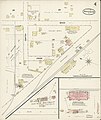
 Sanborn Fire Insurance Map from Anaheim, Orange County, California. LOC sanborn00384 003-1.tif 6,450 × 7,650; 141.17 MB
-

-
 Sanborn Fire Insurance Map from Anaheim, Orange County, California. LOC sanborn00384 003-2.tif 6,450 × 7,650; 141.17 MB
-

-
 Sanborn Fire Insurance Map from Anaheim, Orange County, California. LOC sanborn00384 003-3.tif 6,450 × 7,650; 141.17 MB
-
-
 Sanborn Fire Insurance Map from Anaheim, Orange County, California. LOC sanborn00384 003-4.tif 6,450 × 7,650; 141.17 MB
-

-
 Sanborn Fire Insurance Map from Anaheim, Orange County, California. LOC sanborn00384 003-5.tif 6,450 × 7,650; 141.17 MB
-

-
 Sanborn Fire Insurance Map from Anaheim, Orange County, California. LOC sanborn00384 003-6.tif 6,450 × 7,650; 141.17 MB
-

-
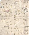
 Sanborn Fire Insurance Map from Antioch, Contra Costa County, California. LOC sanborn00387 002-1.tif 6,450 × 7,650; 141.17 MB
-

-
 Sanborn Fire Insurance Map from Antioch, Contra Costa County, California. LOC sanborn00387 002-2.tif 6,450 × 7,650; 141.17 MB
-
 Sanborn Fire Insurance Map from Davis, Yolo County, California. LOC sanborn00499 001-1.jpg 6,450 × 7,650; 3.43 MB
-
 Sanborn Fire Insurance Map from Davis, Yolo County, California. LOC sanborn00499 001-1.tif 6,450 × 7,650; 141.17 MB
-

-
 Sanborn Fire Insurance Map from Davis, Yolo County, California. LOC sanborn00499 001-2.tif 6,450 × 7,650; 141.17 MB
-
 Sanborn Fire Insurance Map from Dixon, Solano County, California. LOC sanborn00504 002-1.jpg 6,450 × 7,650; 3.51 MB
-
 Sanborn Fire Insurance Map from Dixon, Solano County, California. LOC sanborn00504 002-2.jpg 6,450 × 7,650; 2.95 MB
-
 Sanborn Fire Insurance Map from Dixon, Solano County, California. LOC sanborn00504 002-3.jpg 6,450 × 7,650; 2.92 MB
-
-

-

-

-
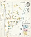
 Sanborn Fire Insurance Map from Mayfield, Santa Clara County, California. LOC sanborn00677 002-1.tif 6,450 × 7,650; 141.17 MB
-

-
 Sanborn Fire Insurance Map from Mayfield, Santa Clara County, California. LOC sanborn00677 002-2.tif 6,450 × 7,650; 141.17 MB
-

-
 Sanborn Fire Insurance Map from Mayfield, Santa Clara County, California. LOC sanborn00677 002-3.tif 6,450 × 7,650; 141.17 MB
-
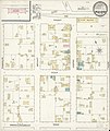
 Sanborn Fire Insurance Map from Modesto, Stanislaus County, California. LOC sanborn00691 002-1.tif 6,450 × 7,650; 141.17 MB
-

-
 Sanborn Fire Insurance Map from Modesto, Stanislaus County, California. LOC sanborn00691 002-2.tif 6,450 × 7,650; 141.17 MB
-

-
 Sanborn Fire Insurance Map from Modesto, Stanislaus County, California. LOC sanborn00691 002-3.tif 6,450 × 7,650; 141.17 MB
-

-
 Sanborn Fire Insurance Map from Modesto, Stanislaus County, California. LOC sanborn00691 002-4.tif 6,450 × 7,650; 141.17 MB
-

-
 Sanborn Fire Insurance Map from Modesto, Stanislaus County, California. LOC sanborn00691 002-5.tif 6,450 × 7,650; 141.17 MB
-

-
 Sanborn Fire Insurance Map from Modesto, Stanislaus County, California. LOC sanborn00691 002-6.tif 6,450 × 7,650; 141.17 MB
-

-
 Sanborn Fire Insurance Map from Modesto, Stanislaus County, California. LOC sanborn00691 002-7.tif 6,450 × 7,650; 141.17 MB
-

-
 Sanborn Fire Insurance Map from Modesto, Stanislaus County, California. LOC sanborn00691 002-8.tif 6,450 × 7,650; 141.17 MB
-
-

-

-
 Sanborn Fire Insurance Map from Oceanside, San Diego County, California. LOC sanborn00731 002-1.tif 6,450 × 7,650; 141.17 MB
-

-
 Sanborn Fire Insurance Map from Oceanside, San Diego County, California. LOC sanborn00731 002-2.tif 6,450 × 7,650; 141.17 MB
-

-
 Sanborn Fire Insurance Map from Woodbridge, San Joquin County, California. LOC sanborn00938 002.tif 6,450 × 7,650; 141.17 MB


