Category:Mawddach Estuary
Jump to navigation
Jump to search

Subcategories
This category has the following 3 subcategories, out of 3 total.
Media in category "Mawddach Estuary"
The following 200 files are in this category, out of 276 total.
(previous page) (next page)-
 158840 , Barmouth Viaduct (7011503433).jpg 4,000 × 2,830; 6.45 MB
-

-
 Aber yr Afon Mawddach - geograph.org.uk - 185718.jpg 640 × 480; 82 KB
-
 Aberamffra Harbour - geograph.org.uk - 739150.jpg 640 × 480; 52 KB
-
 Aberamffra Harbour - geograph.org.uk - 739159.jpg 640 × 480; 52 KB
-
 Aberamffra Harbour - geograph.org.uk - 739167.jpg 640 × 480; 37 KB
-
 Aberamffra Rd looking East - geograph.org.uk - 597326.jpg 640 × 480; 47 KB
-
-
 Afon Mawddach - geograph.org.uk - 1098727.jpg 640 × 480; 195 KB
-
 Afon Mawddach - geograph.org.uk - 1165015.jpg 640 × 360; 30 KB
-
 Afon Mawddach - geograph.org.uk - 214770.jpg 640 × 480; 58 KB
-
 Afon Mawddach - panoramio (1).jpg 4,000 × 3,000; 3.58 MB
-
 Afon Mawddach - panoramio (2).jpg 4,000 × 3,000; 3.41 MB
-
 Afon Mawddach estuary - geograph.org.uk - 1374197.jpg 640 × 480; 47 KB
-
 Afon Mawddach Estuary - geograph.org.uk - 916851.jpg 3,888 × 2,592; 3.61 MB
-
 Arthog Field - geograph.org.uk - 392644.jpg 640 × 480; 84 KB
-
 Arthog from the Old Railway Bridge - geograph.org.uk - 462930.jpg 640 × 480; 150 KB
-
 Arthog, Afon Mawddach - geograph.org.uk - 55096.jpg 640 × 428; 126 KB
-
 At the foot of y Braich - geograph.org.uk - 1752282.jpg 1,024 × 768; 224 KB
-
 Banc-y-Frân - geograph.org.uk - 1752273.jpg 1,024 × 768; 222 KB
-
 Barmouth & Mawddach viaduct (49505381772).jpg 4,608 × 3,456; 11.08 MB
-
 Barmouth (1129366).jpg 1,000 × 754; 188 KB
-
 Barmouth (1132474).jpg 1,000 × 719; 154 KB
-
 Barmouth - geograph.org.uk - 17580.jpg 640 × 480; 58 KB
-
 Barmouth - panoramio (35).jpg 4,608 × 3,456; 3.73 MB
-
 Barmouth and the Mawddach at low tide - geograph.org.uk - 568091.jpg 640 × 482; 69 KB
-
 Barmouth Bridge - geograph.org.uk - 120991.jpg 601 × 398; 39 KB
-
 Barmouth Bridge - geograph.org.uk - 1300696.jpg 640 × 480; 45 KB
-
 Barmouth Bridge - geograph.org.uk - 1310509.jpg 640 × 480; 91 KB
-
 Barmouth bridge - geograph.org.uk - 1315812.jpg 640 × 480; 98 KB
-
 Barmouth Bridge - geograph.org.uk - 1431154.jpg 640 × 480; 102 KB
-
 Barmouth Bridge - geograph.org.uk - 214766.jpg 640 × 470; 58 KB
-
 Barmouth Bridge - geograph.org.uk - 573419.jpg 640 × 480; 84 KB
-
 Barmouth Bridge - geograph.org.uk - 86124.jpg 640 × 480; 72 KB
-
 Barmouth Bridge - geograph.org.uk - 894771.jpg 640 × 480; 51 KB
-
 Barmouth Bridge and Cader Idris - geograph.org.uk - 198021.jpg 640 × 480; 78 KB
-
 Barmouth Bridge and footpath toll house - geograph.org.uk - 462866.jpg 640 × 480; 132 KB
-
 Barmouth bridge and Tyrrau Mawr - geograph.org.uk - 1315947.jpg 640 × 480; 101 KB
-
 Barmouth Bridge at low tide.jpg 3,888 × 2,592; 6.03 MB
-
 Barmouth Bridge, Wales (7946050250).jpg 2,880 × 1,623; 1.84 MB
-
 Barmouth Bridge, Wales (7946054338).jpg 2,880 × 1,623; 1.94 MB
-
 Barmouth Bridge, Wales (7946059554).jpg 2,880 × 1,623; 1.96 MB
-
 Barmouth from Cadair Idris - geograph.org.uk - 1264812.jpg 640 × 480; 61 KB
-
 Barmouth from Cyfannedd-fawr - geograph.org.uk - 1413200.jpg 640 × 480; 75 KB
-
 Barmouth gets the sunshine^ - geograph.org.uk - 1087616.jpg 640 × 480; 145 KB
-
 Barmouth Harbour at sunset - geograph.org.uk - 709394.jpg 640 × 480; 51 KB
-
 Barmouth Railway bridge - panoramio.jpg 4,000 × 3,000; 3.94 MB
-
 Barmouth rooftops - geograph.org.uk - 1316012.jpg 640 × 480; 99 KB
-
 Barmouth station geograph-2523573-by-Ben-Brooksbank.jpg 2,394 × 1,419; 948 KB
-

-
 Barmouth, north Wales (1131201).jpg 1,000 × 832; 126 KB
-
 Barmouth.jpg 1,280 × 960; 323 KB
-
 Barmouth01.jpg 1,152 × 735; 366 KB
-
 Barmouth03.jpg 2,847 × 1,843; 5.2 MB
-
 Bench with decorative supports - geograph.org.uk - 1315917.jpg 480 × 640; 99 KB
-
 Boats on the Mawddach Estuary - geograph.org.uk - 1396645.jpg 640 × 426; 69 KB
-

-
 Brassicasterol PCA.png 432 × 400; 9 KB
-
 Bridge over Mawddach estuary Barmouth.JPG 2,816 × 2,120; 2.8 MB
-
 Bwlch y Rhiwgyr - geograph.org.uk - 1753039.jpg 1,024 × 768; 311 KB
-

-
 Cae Goronwy - geograph.org.uk - 1762551.jpg 1,024 × 768; 373 KB
-
 Cairn & Cist Above Friog - geograph.org.uk - 202263.jpg 640 × 480; 179 KB
-
 Cambrian Coast line at Llwyngwril - geograph.org.uk - 1310696.jpg 640 × 484; 100 KB
-
 Cloud drifting in over the Mawddach estuary - geograph.org.uk - 1754986.jpg 1,024 × 768; 269 KB
-
 Coes Faen - geograph.org.uk - 739139.jpg 640 × 480; 54 KB
-
 Coes-faen across the Mawddach Estuary - geograph.org.uk - 462944.jpg 640 × 480; 138 KB
-
 Coes-faen from Barmouth Bridge - geograph.org.uk - 610691.jpg 640 × 480; 104 KB
-
 Coes-faen from Barmouth Bridge - geograph.org.uk - 985187.jpg 640 × 378; 44 KB
-
 Cormorant-mawddach-01.jpg 1,400 × 1,000; 252 KB
-
 Descent to Barmouth - geograph.org.uk - 1632706.jpg 640 × 465; 59 KB
-
 Diggers on the bridge2 - geograph.org.uk - 607196.jpg 640 × 480; 83 KB
-
 Dolgellau, Afon Mawddach - geograph.org.uk - 55100.jpg 640 × 427; 122 KB
-

-
 Embankment on the Mawddach Trail - geograph.org.uk - 1294478.jpg 640 × 478; 147 KB
-
 Estuary near Arthog - geograph.org.uk - 462926.jpg 640 × 480; 150 KB
-

-
 Fegla fawr from Daran - geograph.org.uk - 391817.jpg 640 × 480; 76 KB
-
 Forest edge near Cae Tudur - geograph.org.uk - 1752687.jpg 1,024 × 768; 300 KB
-
 Forest on Ffridd Rhos - geograph.org.uk - 1752699.jpg 1,024 × 768; 194 KB
-
 From Barmouth Bridge - 29th May 2013 - panoramio.jpg 4,000 × 3,000; 2.08 MB
-
 From Barmouth Bridge - May 2013 - panoramio.jpg 4,000 × 3,000; 1.51 MB
-
 From Fairbourne side of Barmouth Bridge - 29th May 2013 - panoramio.jpg 4,000 × 3,000; 1.22 MB
-
 Garth Isaf - geograph.org.uk - 1455688.jpg 640 × 480; 106 KB
-
 George III Hotel - geograph.org.uk - 421615.jpg 640 × 480; 84 KB
-
 Glan-y-Mawddach - geograph.org.uk - 545395.jpg 640 × 405; 41 KB
-
 Glorious view off the bridge - May 2013 - panoramio.jpg 4,000 × 3,000; 1.2 MB
-
 Golodd farm above the Mawddach estuary - geograph.org.uk - 1752778.jpg 1,024 × 768; 278 KB
-

-
-
 Grey Heron Mawddach Estuary - geograph.org.uk - 512156.jpg 640 × 480; 128 KB
-
 Gwynedd banner Mawddach valley 1.jpg 2,100 × 300; 704 KB
-
 Hillside south of Ty-nant 2 - geograph.org.uk - 1197473.jpg 640 × 416; 60 KB
-
-
 John ‘Warwick’ Smith (circle of) - A sublime landscape - 9595.jpg 2,048 × 1,371; 458 KB
-
 Llanelltyd, UK - panoramio.jpg 4,608 × 3,456; 6.05 MB
-
 Llyn Wylfa - geograph.org.uk - 1312326.jpg 640 × 480; 88 KB
-
 Looking back towards Bwlch y Rhiwgyr - geograph.org.uk - 1754917.jpg 1,024 × 768; 310 KB
-
-
 Looking into the estuary - geograph.org.uk - 1294381.jpg 640 × 478; 126 KB
-

-
 Low flying Plane Mawddach Estuary - geograph.org.uk - 394071.jpg 640 × 480; 87 KB
-
 Low tide on the Mawddach estuary - geograph.org.uk - 507352.jpg 480 × 640; 105 KB
-
 Lower Cwm Llechen - geograph.org.uk - 59675.jpg 640 × 480; 94 KB
-
 Mawddach Estuary (12285438676).jpg 591 × 432; 52 KB
-
 Mawddach Estuary - geograph.org.uk - 1310510.jpg 640 × 480; 85 KB
-
 Mawddach estuary - geograph.org.uk - 1313748.jpg 640 × 480; 91 KB
-
 Mawddach estuary - geograph.org.uk - 1315745.jpg 640 × 480; 100 KB
-
 Mawddach Estuary - geograph.org.uk - 1363563.jpg 640 × 432; 85 KB
-
 Mawddach estuary - geograph.org.uk - 1531878.jpg 640 × 543; 337 KB
-
 Mawddach Estuary - geograph.org.uk - 303118.jpg 640 × 480; 52 KB
-
 Mawddach Estuary - geograph.org.uk - 660407.jpg 640 × 480; 78 KB
-
 Mawddach Estuary - geograph.org.uk - 660464.jpg 640 × 481; 58 KB
-
 Mawddach Estuary - geograph.org.uk - 667249.jpg 640 × 426; 56 KB
-
 Mawddach Estuary - geograph.org.uk - 750949.jpg 640 × 480; 78 KB
-
 Mawddach estuary - geograph.org.uk - 750953.jpg 640 × 480; 39 KB
-
 Mawddach Estuary - geograph.org.uk - 786224.jpg 640 × 480; 51 KB
-
 Mawddach Estuary - geograph.org.uk - 786227.jpg 640 × 480; 63 KB
-
 Mawddach Estuary - geograph.org.uk - 786253.jpg 640 × 480; 121 KB
-
 Mawddach Estuary - geograph.org.uk - 86132.jpg 640 × 480; 95 KB
-
 Mawddach estuary and bridge - geograph.org.uk - 1315839.jpg 640 × 480; 99 KB
-
 Mawddach Estuary at dawn - geograph.org.uk - 579397.jpg 640 × 480; 69 KB
-
 Mawddach estuary from Barmouth Bridge - geograph.org.uk - 392929.jpg 640 × 480; 82 KB
-
 Mawddach Estuary from Dinas Oleu - geograph.org.uk - 185788.jpg 640 × 206; 37 KB
-
 Mawddach Estuary from Foel Ispri - geograph.org.uk - 672504.jpg 640 × 480; 101 KB
-

-
 Mawddach Estuary from Penmaenpool - geograph.org.uk - 349375.jpg 640 × 480; 49 KB
-
 Mawddach estuary from the hills above Barmouth - geograph.org.uk - 1713688.jpg 2,848 × 2,136; 1.7 MB
-

-
 Mawddach Estuary SSSI.jpg 4,032 × 3,024; 2.13 MB
-

-
 Mawddach Estuary. - geograph.org.uk - 247274.jpg 640 × 480; 90 KB
-
 Mawddach estuary. - geograph.org.uk - 586716.jpg 640 × 480; 79 KB
-
 Mawddach Panorama - geograph.org.uk - 1088039.jpg 640 × 480; 145 KB
-
 Mawddach river valley panorama.jpg 4,527 × 479; 599 KB
-
 Mawddach Trail - geograph.org.uk - 1294395.jpg 640 × 478; 136 KB
-
 Mawddach Trail - geograph.org.uk - 1311966.jpg 640 × 480; 74 KB
-
 Mawddach Trail - geograph.org.uk - 1396124.jpg 640 × 480; 82 KB
-
 Mawddach viaduct. (49504654683).jpg 4,229 × 2,350; 5.75 MB
-
 MawddachLB01.JPG 1,600 × 1,200; 455 KB
-
 MawddachLB02.JPG 1,600 × 1,200; 432 KB
-
 MawddachLB03.JPG 1,600 × 1,200; 416 KB
-
 MawddachLB04.JPG 1,600 × 1,200; 444 KB
-
 MawddachLB05.JPG 1,600 × 1,200; 225 KB
-
 MawddachLB06.JPG 1,600 × 1,200; 358 KB
-
 MawddachLB07.JPG 1,600 × 1,200; 271 KB
-
 MawddachLB08.JPG 1,600 × 1,200; 398 KB
-
 MawddachLB09.JPG 1,600 × 1,200; 441 KB
-
 MawddachLB10.JPG 1,600 × 1,200; 442 KB
-
 MawddachLB11.JPG 1,200 × 1,600; 392 KB
-
 MawddachLB12.JPG 1,600 × 1,200; 374 KB
-
 MawddachLB13.JPG 1,600 × 1,200; 431 KB
-
 Me and my shadow - geograph.org.uk - 1088276.jpg 640 × 480; 120 KB
-
 Moored boats in the Mawddach estuary - geograph.org.uk - 545413.jpg 640 × 238; 31 KB
-
 Mouth of Mawddach Estuary - geograph.org.uk - 1413306.jpg 640 × 480; 42 KB
-
 Near Barmouth, Wales (7946072270).jpg 2,880 × 1,623; 1.68 MB
-
 New Precipice Walk - geograph.org.uk - 480100.jpg 640 × 418; 77 KB
-
 North Wales Mawddach.jpg 2,853 × 1,830; 2.65 MB
-
 Northern shore of the Mawddach Estuary - geograph.org.uk - 468141.jpg 640 × 480; 155 KB
-
 Old jetty near Garth Isaf - geograph.org.uk - 1313686.jpg 640 × 480; 96 KB
-
 Old lifeboat station, Barmouth - geograph.org.uk - 600881.jpg 640 × 480; 85 KB
-
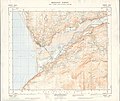 Ordnance Survey Sheet SH 61 Barmouth, Published 1953.jpg 9,618 × 8,128; 29.02 MB
-

-
 Penmaenpool Toll Bridge - geograph.org.uk - 894742.jpg 640 × 480; 37 KB
-
 Penmaenpool toll bridge, Mawddach Estuary SSSI.jpg 4,032 × 3,024; 2.87 MB
-
 Penmaenuchaf Hall (8062263952).jpg 1,280 × 945; 1.27 MB
-
 Pherbina coryleti, Mawddach estuary, North Wales, June 2011 (16777971366).jpg 1,500 × 971; 608 KB
-
 Prochoreutis myllerana, Mawddach estuary, North Wales, June 2011 (20133319030).jpg 1,172 × 1,500; 526 KB
-
 Railway at Barmouth - geograph.org.uk - 468135.jpg 640 × 480; 152 KB
-
 Rainbow over the Mawddach estuary - geograph.org.uk - 601120.jpg 632 × 458; 125 KB
-
 Reed beds beside the Mawddach Estuary - geograph.org.uk - 1088216.jpg 640 × 480; 197 KB
-
 Rhos-caerau - geograph.org.uk - 1752475.jpg 1,024 × 768; 314 KB
-
 River Bank - geograph.org.uk - 130019.jpg 640 × 480; 65 KB
-
 Road and railway, Fairbourne - geograph.org.uk - 1313571.jpg 640 × 480; 97 KB
-

-

-
 Salt marsh on the Mawddach estuary - geograph.org.uk - 1432285.jpg 640 × 428; 94 KB
-
 Salt marsh, Mawddach estuary - geograph.org.uk - 1313575.jpg 640 × 480; 98 KB
-
 Salt marsh, Mawddach estuary - geograph.org.uk - 1313580.jpg 640 × 480; 99 KB
-
 Saltmarsh beside Afon Mawddach - geograph.org.uk - 1100279.jpg 640 × 480; 116 KB
-
 Saltmarsh by the Mawddach Estuary - geograph.org.uk - 1088658.jpg 640 × 480; 173 KB
-
 Sea Defences, Mawddach Estuary - geograph.org.uk - 910672.jpg 640 × 480; 101 KB
-
 Seat on the New Precipice Walk - geograph.org.uk - 1099102.jpg 640 × 480; 111 KB
-
 SH6115 day break in Barmouth Harbour - geograph.org.uk - 613982.jpg 640 × 480; 56 KB
-
 Siphona geniculata, Mawddach estuary, North Wales, June 2011 (17688030925).jpg 1,500 × 1,092; 630 KB
-
 Siphona geniculata, Mawddach estuary, North Wales, June 2011 2 (17661729416).jpg 1,500 × 1,126; 581 KB
-

-
 Southern Diffwys ridge - geograph.org.uk - 1755111.jpg 1,024 × 768; 200 KB
-
 Southern end of the Diffwys ridge - geograph.org.uk - 1752932.jpg 1,024 × 768; 230 KB
-
-
 Summit of Diffwys - geograph.org.uk - 1238630.jpg 640 × 429; 52 KB
-

-
 The Clock House - geograph.org.uk - 738634.jpg 640 × 480; 59 KB
-

-
 The Clock House, Barmouth.jpg 5,184 × 3,456; 12.67 MB
-
 The Estuary from Mawddach Crescent - geograph.org.uk - 462909.jpg 640 × 480; 150 KB
-
 The estuary of the Afon Mawddach - geograph.org.uk - 2615716.jpg 3,264 × 2,448; 3.08 MB
-
 The estuary of the Afon Mawddach - geograph.org.uk - 2615719.jpg 3,264 × 2,448; 2.46 MB
-
 The Mawddach Estuary - geograph.org.uk - 1024534.jpg 640 × 426; 84 KB
-
 The Mawddach Estuary - geograph.org.uk - 1087626.jpg 640 × 480; 106 KB
.jpg)


.jpg)
.jpg)


.jpg)
.jpg)
.jpg)

.jpg)


.jpg)
.jpg)
.jpg)


.jpg)


_-_A_sublime_landscape_-_9595.jpg)


.jpg)


.jpg)


.jpg)


.jpg)
.jpg)
.jpg)


.jpg)
.jpg)


