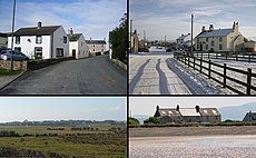
Category:Mawbray
Jump to navigation
Jump to search
English: Mawbray is a village in northern Cumbria, United Kingdom. It is located on the Solway Plain, approximately halfway between the coastal towns of Maryport and Silloth. The B5300, known locally as the "coast road" runs to the west of the village. The name "Mawbray" is believed to be derived from Latin, meaning "a maiden's castle or fort". This would be consistent with Roman mile-forts known to exist nearby on the coast, especially in the Maryport area.
village in United Kingdom | |||||
| Upload media | |||||
| Instance of | |||||
|---|---|---|---|---|---|
| Location | Holme St Cuthbert, Allerdale, Cumbria, North West England, England | ||||
 | |||||
Media in category "Mawbray"
The following 38 files are in this category, out of 38 total.
-
Across the fields to Mawbray - geograph.org.uk - 63960.jpg 640 × 480; 89 KB
-
B5300 April 2019 Closure.jpg 4,032 × 3,024; 4.26 MB
-
Ditch digging and fencing - geograph.org.uk - 63957.jpg 640 × 480; 96 KB
-
Gincase animal farm - geograph.org.uk - 1026310.jpg 640 × 480; 82 KB
-
Mawbray - geograph.org.uk - 572466.jpg 640 × 480; 223 KB
-
Mawbray Compilation II.jpg 1,286 × 794; 435 KB
-
Mawbray Compilation.jpg 640 × 1,766; 433 KB
-
Mawbray fisherman.JPG 3,264 × 2,448; 1.77 MB
-
Scar near Mawbray Bank - geograph.org.uk - 65422.jpg 640 × 480; 82 KB
-
Shingle beach at Mawbray - geograph.org.uk - 572462.jpg 640 × 480; 168 KB
-
The hill at Salta.jpg 2,798 × 2,099; 2.24 MB
-
Beach at Mawbray, with incoming tide - geograph.org.uk - 572454.jpg 640 × 480; 132 KB
-
Beach, near Dubmill Point - geograph.org.uk - 63940.jpg 640 × 480; 75 KB
-
Black Dub,nr Oldkiln - geograph.org.uk - 63943.jpg 473 × 640; 88 KB
-
Damaged Sea Defences Dubmill - geograph.org.uk - 102790.jpg 640 × 480; 78 KB
-
Ditch and Public Right of Way - geograph.org.uk - 102802.jpg 640 × 480; 111 KB
-
Entrance to Manor House Caravan Park - geograph.org.uk - 598942.jpg 640 × 480; 183 KB
-
Farming pens on the lane. - geograph.org.uk - 144670.jpg 640 × 480; 78 KB
-
Footpath near Edderside - geograph.org.uk - 63946.jpg 480 × 640; 116 KB
-
Footpath to Plasketlands Farm - geograph.org.uk - 91802.jpg 640 × 427; 123 KB
-
Footpath to Salta - geograph.org.uk - 572472.jpg 640 × 480; 189 KB
-
Gincase Farm Park, Mawbray Hayrigg - geograph.org.uk - 58519.jpg 640 × 480; 156 KB
-
Herding Cattle - geograph.org.uk - 63949.jpg 640 × 480; 86 KB
-
Hill House, Salta - geograph.org.uk - 63945.jpg 640 × 480; 69 KB
-
Looking down to Black Dub. - geograph.org.uk - 144672.jpg 640 × 480; 53 KB
-
Lowther Arms, Mawbray - geograph.org.uk - 572470.jpg 640 × 480; 151 KB
-
Lowther Arms, Mawbray - geograph.org.uk - 63958.jpg 640 × 480; 72 KB
-
Mawbray Bank - geograph.org.uk - 65421.jpg 480 × 640; 124 KB
-
Mawbray Bank, looking north - geograph.org.uk - 65425.jpg 640 × 480; 96 KB
-
Out To Sea Dubmill Sands - geograph.org.uk - 102785.jpg 640 × 465; 73 KB
-
Road junction - geograph.org.uk - 572480.jpg 608 × 456; 145 KB
-
Road to Salta - geograph.org.uk - 572476.jpg 640 × 480; 174 KB
-
Sands off Dubmill Point - geograph.org.uk - 102770.jpg 640 × 480; 73 KB
-
Sea Defence Dubmill - geograph.org.uk - 102795.jpg 640 × 480; 75 KB
-
Seacroft Farm, Dubmill Point - geograph.org.uk - 63941.jpg 640 × 480; 68 KB
-
Shingle Beach Mawbray - geograph.org.uk - 91795.jpg 640 × 427; 115 KB
-
The Solway Firth - geograph.org.uk - 573123.jpg 640 × 480; 94 KB
-
Unstylish Stile - geograph.org.uk - 102808.jpg 640 × 480; 127 KB


