Category:Mathekenyane
Jump to navigation
Jump to search
Afrikaans: Granokop (385 m) langs die H1-1 is 'n uitsigpunt en een van die granietkoppies wat in 'n band van wes na oos in die suidelike Nasionale Krugerwildtuin aangetref word.
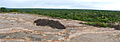
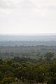
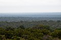
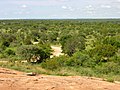
English: Mat(h)ekenyane (i.e. "place of the sand flea," cf. Talitridae or Hectopsyllidae) or Granokop (385 m) is a granite outcrop and viewpoint in the southern Kruger National Park, Mpumalanga, South Africa. It can be accessed from the H1-1 road.
| Object location | | View all coordinates using: OpenStreetMap |
|---|
hill in Mpumalanga, South Africa  | |||||
| Upload media | |||||
| Instance of | |||||
|---|---|---|---|---|---|
| Location | Ehlanzeni District Municipality, Mpumalanga, Transvaal region | ||||
 | |||||
Media in category "Mathekenyane"
The following 19 files are in this category, out of 19 total.
-
 Matekenyane, Krugerův Park - panoramio.jpg 4,928 × 3,264; 11.7 MB
-
 Pohled z Matekenyane, Krugerův Park - panoramio.jpg 4,928 × 3,264; 8.97 MB
-
 View from Mathekenyane (16597793928).jpg 5,424 × 1,920; 5.44 MB
-
 2013-02-23 11-00-28 South Africa Mpumalanga - Kruger National Park 9h.JPG 15,616 × 1,958; 12.36 MB
-
 Dimming (2349815462).jpg 4,288 × 2,848; 2.35 MB
-
 Mathekenyane (4099201696).jpg 2,848 × 4,288; 2.86 MB
-
 Mathekenyane Rock (3464555988).jpg 4,288 × 2,848; 4.29 MB
-
 Mathekenyane View (3464557882).jpg 2,848 × 4,288; 1.4 MB
-
 Mathekenyane Vista (3464557014).jpg 3,766 × 2,501; 1.53 MB
-
 Road to the rock (394287741).jpg 3,264 × 2,448; 1.7 MB
-
 The Lowveld (4098445581).jpg 4,288 × 2,848; 4.46 MB
-
 The veld (394286800).jpg 3,264 × 2,448; 2.41 MB
-
 Vanellus armatus -Kruger National Park, South Africa-8.jpg 3,483 × 2,322; 2.47 MB
-
 Yellow-billed Kite 2246407271 crop.jpg 968 × 1,304; 468 KB
-
 Yellow-billed Kite 2246407271.jpg 4,288 × 2,848; 556 KB
-
 Broad-bordered Grass Yellow Eurema brigitta (8391842065).jpg 4,320 × 2,430; 1.92 MB
-
 Carpenter Bee (Xylocopa inconstans, female) (6021534858).jpg 1,371 × 951; 339 KB
-
 Carpenter Bee (Xylocopa sp.) (6021534858).jpg 4,320 × 2,592; 2.1 MB
-
 Common Orange Tip (Colotis evenina) female (32718355393).jpg 3,045 × 3,225; 6.91 MB

.jpg)
.jpg)
.jpg)
.jpg)
.jpg)
.jpg)
.jpg)
.jpg)


.jpg)
_(6021534858).jpg)
_(6021534858).jpg)
_female_(32718355393).jpg)
.jpg)