Category:Mashpee, Massachusetts
Jump to navigation
Jump to search
town in Barnstable County, Massachusetts, United States  .png)  | |||||
| Upload media | |||||
| Instance of | |||||
|---|---|---|---|---|---|
| Part of | |||||
| Location | Barnstable County, Massachusetts | ||||
| Inception |
| ||||
| Population |
| ||||
| Area |
| ||||
| Elevation above sea level |
| ||||
| official website | |||||
 | |||||
Subcategories
This category has the following 10 subcategories, out of 10 total.
E
- Events in Mashpee, Massachusetts (17 F)
M
- Mashpee Neck, Massachusetts (2 F)
- Mashpee River (2 F)
N
- New Seabury, Massachusetts (3 F)
O
- Old Indian Meeting House (13 F)
P
- Popponesset, Massachusetts (5 F)
Media in category "Mashpee, Massachusetts"
The following 34 files are in this category, out of 34 total.
-
 101.1 WHYA Mashpee.png 1,000 × 376; 69 KB
-
 1891 Mashpee public library Massachusetts.png 494 × 359; 123 KB
-
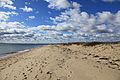
 Beach, Conaumet Cove, Mashpee MA.jpg 3,264 × 2,448; 3.07 MB
-
 Boardwalk @ Southcape Beach - panoramio.jpg 5,616 × 3,744; 8.93 MB
-
 Boats On Seconsett - panoramio.jpg 5,616 × 3,744; 6.09 MB
-
 Cape Cod, United States (Unsplash).jpg 4,928 × 3,264; 3.66 MB
-
 Conaumet Cove, Lowell Holly Reservation, Mashpee MA.jpg 3,264 × 2,448; 2.61 MB
-
 From Meadow Neck Road - panoramio.jpg 5,616 × 3,744; 4.71 MB
-
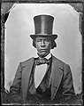 James Mye 1860.jpg 557 × 700; 176 KB
-
 Little River Boatyard, Seconsett Island MA.jpg 3,264 × 2,448; 3.06 MB
-
 Looking at you, Seconsett... - panoramio.jpg 5,379 × 3,586; 4.04 MB
-
 MA Route 130 northbound entering Mashpee MA.jpg 2,592 × 1,944; 1.28 MB
-
 Mashpee MA Town Hall.jpg 1,000 × 750; 96 KB
-
 Mashpee National Wildlife Refuge.jpg 680 × 312; 169 KB
-
 Mashpee River, Mashpee River Reservation, Mashpee MA.jpg 3,264 × 2,448; 2.49 MB
-
 Mashpee Wampanoag Indian Museum.jpg 2,448 × 3,264; 3.36 MB
-
 MashpeeMA AvantHouse.jpg 1,024 × 680; 324 KB
-
 Monomoscoy Island, Mashpee MA.jpg 3,264 × 2,448; 1.74 MB
-
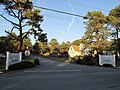
 North Street, Mashpee Commons, Mashpee MA (cropped).jpg 2,800 × 400; 372 KB
-
 North Street, Mashpee Commons, Mashpee MA.jpg 3,264 × 2,448; 1.8 MB
-
 One Room Schoolhouse, Mashpee MA.jpg 2,592 × 1,944; 1.86 MB
-
 Rainy Day @ Ockway Bay - panoramio.jpg 2,592 × 1,936; 1.5 MB
-
 Red Brook Reservoir - panoramio.jpg 2,592 × 1,936; 1.81 MB
-
 Restored tidal flow (15595610649).jpg 4,000 × 3,000; 3.8 MB
-
 Richard Bourne, missionary to the Mashpee Indians (IA richardbournemis00ayer).pdf 839 × 1,406, 14 pages; 544 KB
-
 Sage Lot Pond - panoramio.jpg 3,648 × 2,736; 2.09 MB
-
 Santuit River (Massachusetts) map.jpg 1,181 × 2,482; 1.01 MB
-
 Seal of Mashpee, Massachusetts (1899–2021).png 750 × 790; 866 KB
-
 Seconsett Island MA.jpg 3,264 × 2,448; 2.04 MB
-
 South Cape Beach State Park, Mashpee MA.jpg 3,264 × 2,448; 1.84 MB
-
 Southcape Beach - panoramio.jpg 5,616 × 3,744; 8.63 MB
-
 Stoner's Pit - panoramio.jpg 5,616 × 3,744; 7.88 MB
-
 Surf Drive, Mashpee MA.jpg 3,264 × 2,448; 2.37 MB
-
 The Black Dog, Mashpee Commons, Mashpee MA.jpg 3,264 × 2,448; 2 MB


.jpg)


.jpg)

_map.jpg)


.jpg)