Category:Mas del Pere Domènech
Jump to navigation
Jump to search
| Object location | | View all coordinates using: OpenStreetMap |
|---|
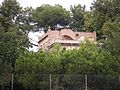
masia in Reus (Baix Camp, Catalonia)  | |||||
| Upload media | |||||
| Instance of | |||||
|---|---|---|---|---|---|
| Location | Reus, Baix Camp, Camp de Tarragona, Province of Tarragona, Catalonia | ||||
| Architectural style | |||||
| Heritage designation |
| ||||
 | |||||
Català: Mas del Pere Domènech (Reus)
This is a category about a building listed in the Catalan heritage register as Bé Cultural d'Interès Local (BCIL) under the reference IPA-9849. |
Media in category "Mas del Pere Domènech"
The following 2 files are in this category, out of 2 total.
-
 Mas del Pere Domènech.jpg 4,288 × 3,216; 2.19 MB
-
 Mas del Pere Domènech1.jpg 4,288 × 3,216; 1.95 MB
