Category:Marown
Jump to navigation
Jump to search
parish of the Isle of Man  | |||||
| Upload media | |||||
| Instance of |
| ||||
|---|---|---|---|---|---|
| Location | Middle, Isle of Man, Irish Sea | ||||
 | |||||
Subcategories
This category has the following 3 subcategories, out of 3 total.
Media in category "Marown"
The following 145 files are in this category, out of 145 total.
-
 A stream leading to Glen Vine - geograph.org.uk - 3627509.jpg 640 × 480; 102 KB
-
 A1 junction in Glen Vine - geograph.org.uk - 1883772.jpg 800 × 600; 142 KB
-
 A23 Mount Rule Road near Upper Ballaclucas - geograph.org.uk - 5737031.jpg 1,600 × 1,065; 620 KB
-
 A23 Top Road at Glenvine Road - geograph.org.uk - 5737078.jpg 1,600 × 1,065; 544 KB
-
 A23 Top Road towards Ballakelly - geograph.org.uk - 5737042.jpg 1,600 × 1,065; 564 KB
-
 A23 Top Road towards Ballakelly - geograph.org.uk - 5737051.jpg 1,600 × 1,065; 583 KB
-
 A24 Foxdale Road - geograph.org.uk - 1845627.jpg 800 × 600; 84 KB
-
 A24 Foxdale Road - geograph.org.uk - 1845648.jpg 800 × 600; 86 KB
-
 A24 Foxdale Road, approaching Braaid - geograph.org.uk - 1845677.jpg 800 × 600; 114 KB
-
 A24 Foxdale Road, Braaid - geograph.org.uk - 1845698.jpg 800 × 600; 133 KB
-
 A26, Braaid - geograph.org.uk - 1845708.jpg 800 × 600; 110 KB
-
 Approaching Braaid - geograph.org.uk - 1979888.jpg 2,816 × 2,112; 1.08 MB
-
 Approaching Crosby - geograph.org.uk - 3937275.jpg 424 × 640; 72 KB
-
 Archallagan Plantation, conifers - geograph.org.uk - 4617080.jpg 768 × 1,024; 254 KB
-
 Archallagan Plantation, conifers - geograph.org.uk - 4617092.jpg 768 × 1,024; 241 KB
-
 Archallagan Plantation, forestry road - geograph.org.uk - 4616980.jpg 1,024 × 768; 271 KB
-
 Archallagan Plantation, forestry road - geograph.org.uk - 4617084.jpg 1,024 × 768; 195 KB
-
 Archallagan Plantation, forestry road - geograph.org.uk - 4617094.jpg 1,024 × 768; 294 KB
-
 Bend in the Trail - geograph.org.uk - 3937267.jpg 640 × 424; 73 KB
-
 Beside The Heritage Trail - geograph.org.uk - 4428474.jpg 424 × 640; 81 KB
-
 Braaid taken from Cronk ny Moghlane - geograph.org.uk - 5737085.jpg 1,600 × 1,065; 509 KB
-
 Campbells Bridge - geograph.org.uk - 1968048.jpg 1,024 × 768; 174 KB
-
 Central Valley Curragh - geograph.org.uk - 3935266.jpg 424 × 640; 117 KB
-
 Confluence by the Heritage Trail - geograph.org.uk - 4428489.jpg 424 × 640; 99 KB
-
 Confluence on the River Dhoo - geograph.org.uk - 4428553.jpg 424 × 640; 90 KB
-
 Cooil Road A24 - geograph.org.uk - 1845602.jpg 800 × 600; 82 KB
-
 Crosby Crossing (A walk continued) - geograph.org.uk - 4428457.jpg 640 × 424; 110 KB
-
 Curragh Beside the Heritage Trail - geograph.org.uk - 3935271.jpg 424 × 640; 121 KB
-
 Derelict building on Trollaby Lane - geograph.org.uk - 5736169.jpg 1,600 × 1,065; 737 KB
-
 Driveway to Coan Reayrt, Ballakelly - geograph.org.uk - 5737049.jpg 1,600 × 1,065; 673 KB
-
 Eairy Valley - geograph.org.uk - 1990531.jpg 2,816 × 2,112; 1.02 MB
-
 Farm track towards Baldwin - geograph.org.uk - 5737868.jpg 1,600 × 1,065; 622 KB
-
 Fields above Crosby - geograph.org.uk - 1063493.jpg 640 × 406; 106 KB
-
 Footpath towards Upper Ballaclucas - geograph.org.uk - 5722576.jpg 1,600 × 1,065; 620 KB
-
 Footpath towards Upper Ballaclucas - geograph.org.uk - 5736942.jpg 1,600 × 1,065; 598 KB
-
 Footpath towards Upper Ballaclucas - geograph.org.uk - 5736945.jpg 1,600 × 1,065; 691 KB
-
 Footpath towards Upper Ballaclucas - geograph.org.uk - 5736952.jpg 1,600 × 1,065; 624 KB
-
 Footpath towards Upper Ballaclucas - geograph.org.uk - 5736955.jpg 1,600 × 1,065; 702 KB
-
 Footpath towards Upper Ballaclucas - geograph.org.uk - 5737014.jpg 1,600 × 1,065; 917 KB
-
 Former Highlander Public House.jpg 3,482 × 1,839; 1.96 MB
-
 Garth Road - geograph.org.uk - 1979960.jpg 2,816 × 2,112; 1.02 MB
-
 Glen Darragh Mill - geograph.org.uk - 4619227.jpg 1,024 × 768; 219 KB
-
 Glen Vine, New Parish Church - geograph.org.uk - 4619270.jpg 1,024 × 768; 144 KB
-
 Glen Vine, Steam Heritage Trail - geograph.org.uk - 4619241.jpg 1,024 × 768; 286 KB
-
 Glenvine Road from Top Road, Ballakelly - geograph.org.uk - 5737053.jpg 1,600 × 1,065; 460 KB
-
 Houses on Mount Rule Road, Upper Ballaclucas - geograph.org.uk - 5737027.jpg 1,600 × 1,065; 614 KB
-
 Little Mount near Ballakelly - geograph.org.uk - 5737044.jpg 1,600 × 1,065; 438 KB
-
 Looking towards Glen Vine - geograph.org.uk - 1845577.jpg 800 × 445; 95 KB
-
 Manx Heritage Trail and Signs of Spring - geograph.org.uk - 4428507.jpg 640 × 424; 133 KB
-
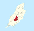 Marown in Isle of Man.svg 1,200 × 1,100; 171 KB
-
 Marown School Nature Area Glen Vine - geograph.org.uk - 4428494.jpg 424 × 640; 124 KB
-
 Millennium Way at Upper Ballagrawe - geograph.org.uk - 5737881.jpg 1,600 × 1,065; 929 KB
-
 Millennium Way at Upper Ballagrawe - geograph.org.uk - 5737886.jpg 1,600 × 1,065; 757 KB
-
 Millennium Way near Braaid - geograph.org.uk - 5737134.jpg 1,600 × 1,065; 558 KB
-
 Millennium Way near Braaid - geograph.org.uk - 5737135.jpg 1,600 × 1,065; 651 KB
-
 Millennium Way near Braaid - geograph.org.uk - 5737668.jpg 1,600 × 1,065; 1.04 MB
-
 Millennium Way near Sander Farm - geograph.org.uk - 5737745.jpg 1,600 × 1,065; 903 KB
-
 Millennium Way near Sander Farm - geograph.org.uk - 5737870.jpg 1,600 × 1,065; 843 KB
-
 Millennium Way near Upper Ballagrawe - geograph.org.uk - 5737927.jpg 1,600 × 1,065; 875 KB
-

-
 Millennium Way towards Baldwin - geograph.org.uk - 5722637.jpg 1,600 × 1,065; 913 KB
-
 Millennium Way towards Baldwin - geograph.org.uk - 5737568.jpg 1,600 × 1,065; 495 KB
-
 Millennium Way towards Baldwin - geograph.org.uk - 5737570.jpg 1,600 × 1,065; 775 KB
-
 Millennium Way towards Baldwin - geograph.org.uk - 5737573.jpg 1,600 × 1,065; 780 KB
-
 Millennium Way towards Baldwin - geograph.org.uk - 5737661.jpg 1,600 × 1,065; 679 KB
-
 Millennium Way towards Baldwin - geograph.org.uk - 5737663.jpg 1,600 × 1,065; 954 KB
-
 Millennium Way towards Baldwin - geograph.org.uk - 5737670.jpg 1,600 × 1,065; 660 KB
-
 Millennium Way towards Baldwin - geograph.org.uk - 5737673.jpg 1,600 × 1,065; 542 KB
-
 Millennium Way towards Baldwin - geograph.org.uk - 5737677.jpg 1,600 × 1,065; 673 KB
-
 Millennium Way towards Baldwin - geograph.org.uk - 5737681.jpg 1,600 × 1,065; 869 KB
-
 Millennium Way towards Baldwin - geograph.org.uk - 5737929.jpg 1,600 × 1,065; 933 KB
-
 Millennium Way towards Ballagrawe - geograph.org.uk - 5722634.jpg 1,600 × 1,065; 797 KB
-
 Millennium Way towards Ballalough - geograph.org.uk - 5722625.jpg 1,600 × 1,065; 703 KB
-
 Millennium Way towards Block Eary - geograph.org.uk - 5737087.jpg 1,600 × 1,065; 519 KB
-
 Millennium Way towards Cronk Breck - geograph.org.uk - 5722620.jpg 1,600 × 1,065; 510 KB
-
 Mount Rules Road at Ballaclucas - geograph.org.uk - 5722592.jpg 1,600 × 1,065; 614 KB
-

-
 Old Milestone by the A26, Corvalley, Isle of Man - geograph.org.uk - 5365705.jpg 1,200 × 1,600; 676 KB
-
 Outbuilding at Ellerslie Farm - geograph.org.uk - 3642258.jpg 640 × 480; 79 KB
-
 Parish-Marown.svg 744 × 1,052; 89 KB
-
 Pastures above West Baldwin - geograph.org.uk - 649678.jpg 427 × 640; 82 KB
-
 Pond Beside Forest Track - geograph.org.uk - 3415934.jpg 2,560 × 1,920; 2.8 MB
-
 Resurfacing the Heritage Trail - geograph.org.uk - 4428534.jpg 424 × 640; 81 KB
-
 River Dhoo in Crosby - geograph.org.uk - 3935282.jpg 424 × 640; 107 KB
-
 Road leading to Baldwin - geograph.org.uk - 5737041.jpg 1,600 × 1,065; 651 KB
-
 Road leading to Cronk Break - geograph.org.uk - 5737082.jpg 1,600 × 1,065; 592 KB
-
 Road leading to Cronk Break - geograph.org.uk - 5737084.jpg 1,600 × 1,065; 503 KB
-
 Road leading to Cronk ny Moghlane - geograph.org.uk - 5722608.jpg 1,600 × 1,065; 864 KB
-
 Road leading to the A23 Top Road - geograph.org.uk - 5737080.jpg 1,600 × 1,065; 630 KB
-
 Sanders Farm - geograph.org.uk - 5722630.jpg 1,600 × 1,065; 587 KB
-
 Sanders Farm near Baldwin - geograph.org.uk - 5737755.jpg 1,600 × 1,065; 760 KB
-
 Sanders Farm near Baldwin - geograph.org.uk - 5737862.jpg 1,600 × 1,065; 736 KB
-
 Sanders Farm near Baldwin - geograph.org.uk - 5737864.jpg 1,600 × 1,065; 639 KB
-
 Seat in the Curragh - geograph.org.uk - 3937260.jpg 424 × 640; 84 KB
-
 Slieau Chiarn - geograph.org.uk - 3415921.jpg 2,560 × 1,920; 2.67 MB
-
 St Marks, brook - geograph.org.uk - 4616945.jpg 1,024 × 768; 213 KB
-
 St Marks, Campbell Bridge - geograph.org.uk - 4616949.jpg 1,024 × 768; 181 KB
-
 St Marks, Santon Burn - geograph.org.uk - 4616954.jpg 1,024 × 768; 212 KB
-

-

-

-

-

-

-

-

-

-

-

-

-

-

-

-

-
-

-

-
 Steps by the Heritage Trail - geograph.org.uk - 4428478.jpg 424 × 640; 100 KB
-
 Summit area of Slieau Ruy - geograph.org.uk - 6660513.jpg 1,999 × 1,052; 2.06 MB
-
 The Braaid - geograph.org.uk - 4113305.jpg 5,444 × 2,500; 3.52 MB
-
 The Millennium Way at West Baldwin - geograph.org.uk - 649662.jpg 640 × 427; 159 KB
-
 Track heading up towards Slieau Ruy at Cronk Breck - geograph.org.uk - 6494918.jpg 1,799 × 1,199; 384 KB
-
 Tractor in a field - geograph.org.uk - 3642263.jpg 640 × 480; 102 KB
-
 Trig Point on Slieau Ruy above Crosby - geograph.org.uk - 5619603.jpg 5,184 × 2,920; 5.06 MB
-
 Trig point on the summit of Slieau Ruy - geograph.org.uk - 2145336.jpg 1,024 × 768; 218 KB
-
 Trollaby House on Trollaby Lane - geograph.org.uk - 5736176.jpg 1,600 × 1,065; 736 KB
-
 Trollaby Lane towards Upper Ballaclucas - geograph.org.uk - 5722567.jpg 1,600 × 1,065; 790 KB
-
 Trollaby Lane towards Upper Ballaclucas - geograph.org.uk - 5736146.jpg 1,600 × 1,065; 783 KB
-
 Trollaby Lane towards Upper Ballaclucas - geograph.org.uk - 5736148.jpg 1,600 × 1,065; 759 KB
-
 Trollaby Lane towards Upper Ballaclucas - geograph.org.uk - 5736161.jpg 1,600 × 1,065; 941 KB
-
 Trollaby Lane towards Upper Ballaclucas - geograph.org.uk - 5736166.jpg 1,600 × 1,065; 782 KB
-
 Trollaby Lane, Union Mills - geograph.org.uk - 5736141.jpg 1,600 × 1,065; 852 KB
-
 TT Lap ^8 Roadworks in Glen Vine - geograph.org.uk - 5742859.jpg 640 × 424; 80 KB
-
 Union Mills Youth Hostel - geograph.org.uk - 2818500.jpg 642 × 373; 62 KB
-
 Upper Ballagrawe near Baldwin - geograph.org.uk - 5737889.jpg 1,600 × 1,065; 682 KB
-
 Upper Trollaby Lane towards Upper Ballaclucas - geograph.org.uk - 5737017.jpg 1,600 × 1,065; 798 KB
-
 Upper Trollaby Lane towards Upper Mount Rule Road - geograph.org.uk - 5737020.jpg 1,600 × 1,065; 611 KB
-
 Valtra Tractor - geograph.org.uk - 3642247.jpg 640 × 480; 83 KB
-
 View from Cooil Road - geograph.org.uk - 4306350.jpg 640 × 256; 31 KB
-
 View to Slieau Ruy from Cronk Breac above Crosby - geograph.org.uk - 5619607.jpg 5,184 × 2,920; 5.38 MB
-
 View towards Carraghan from path below Slieau Ruy - geograph.org.uk - 5619604.jpg 5,184 × 2,920; 5.31 MB
-

-
 Warning Vehicle Reversing^ - geograph.org.uk - 4428520.jpg 424 × 640; 94 KB
-

-
 Glenlough Keeill on Glenlough Farm, Marown - geograph.org.uk - 58774.jpg 640 × 480; 187 KB


_-_geograph.org.uk_-_4428457.jpg)


_-_geograph.org.uk_-_2113344.jpg)
_-_geograph.org.uk_-_2113345.jpg)
_-_geograph.org.uk_-_2113350.jpg)
_-_geograph.org.uk_-_2113353.jpg)
_-_geograph.org.uk_-_2113368.jpg)
_-_geograph.org.uk_-_2113370.jpg)
_-_geograph.org.uk_-_2113374.jpg)
_-_geograph.org.uk_-_2113376.jpg)
_-_geograph.org.uk_-_2113378.jpg)
_-_geograph.org.uk_-_2113448.jpg)
_-_geograph.org.uk_-_2113450.jpg)
_-_geograph.org.uk_-_2113453.jpg)
_-_geograph.org.uk_-_2113461.jpg)
_-_geograph.org.uk_-_2113466.jpg)
_-_geograph.org.uk_-_2113475.jpg)
_-_geograph.org.uk_-_2113482.jpg)
_-_geograph.org.uk_-_2113487.jpg)
_-_geograph.org.uk_-_2113494.jpg)
_-_geograph.org.uk_-_2113497.jpg)


