Category:Marlborough House, Liverpool
Jump to navigation
Jump to search
| Object location | | View all coordinates using: OpenStreetMap |
|---|
house in Liverpool, Merseyside, England, UK  | |||||
| Upload media | |||||
| Instance of | |||||
|---|---|---|---|---|---|
| Location | Liverpool, Merseyside, North West England, England | ||||
| Heritage designation |
| ||||
 | |||||
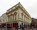
52 Bold Street, Liverpool, built early 19th century as a concert hall, remodelled c. 1853. Grade II listed, later a shop and as of 2018 a bar, Coyote Ugly.
Media in category "Marlborough House, Liverpool"
The following 3 files are in this category, out of 3 total.
-
 Concert Street 2.jpg 4,368 × 3,126; 7.01 MB
-
 Marlborough House, Liverpool 1.jpg 3,708 × 3,103; 5.5 MB
-
 Marlborough House, Liverpool 2.jpg 3,346 × 3,007; 4.79 MB

