Category:Marienkirche (Angermünde)
Jump to navigation
Jump to search
| Object location | | View all coordinates using: OpenStreetMap |
|---|
church building in Angermünde, Brandenburg state, Germany   | |||||
| Upload media | |||||
| Instance of | |||||
|---|---|---|---|---|---|
| Named after | |||||
| Location | Angermünde, Uckermark District, Brandenburg, Germany | ||||
| Architectural style | |||||
| Heritage designation | |||||
 | |||||
This is the category of the Brandenburger Baudenkmal (cultural heritage monument) with the ID 09130264 (Wikidata)
|
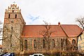
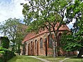
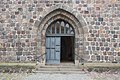
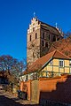
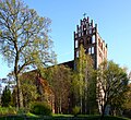
Deutsch: Die Stadtpfarrkirche Sankt Marien in Angermünde, Mark Brandenburg, gehört und dient einer Gemeinde der unierten Evangelischen Kirche Berlin-Brandenburg-Schlesische Oberlausitz. Die Kirche entstand Mitte oder im 3. Viertel des 13. Jh.s und wurde im 15. Jh. erweitert.
English: The City Parish Church of St. Mary's in Angermünde, March of Brandenburg, Germany, is owned and used by a congregation within the Evangelical Church of Berlin-Brandenburg-Silesian Upper Lusatia, a united Protestant church body of Calvinist, Lutheran and united congregations. The church was erected in the mid of or the 3rd quarter of the 13th c. and was extended in the 15th c.
Subcategories
This category has only the following subcategory.
I
Media in category "Marienkirche (Angermünde)"
The following 26 files are in this category, out of 26 total.
-
 2010-03-05-angermuende-by-RalfR-33.jpg 2,848 × 4,288; 6.18 MB
-
 2010-03-05-angermuende-by-RalfR-34.jpg 4,288 × 2,848; 6.54 MB
-
 2010-03-05-angermuende-by-RalfR-35.jpg 4,288 × 2,848; 6.94 MB
-
 2010-03-05-angermuende-by-RalfR-38.jpg 4,288 × 2,848; 4.47 MB
-
 2018 04 StadtpfarrkircheSanktMarienAngermuende IMG 0833.jpg 6,000 × 4,000; 8.74 MB
-
 ANG002-Marienkirche.jpg 4,000 × 6,000; 27.37 MB
-
 AngermuendeSt Marienkirche001.jpg 4,000 × 6,000; 21.6 MB
-
 Angermünde - Evang. Stadtkirche St. Marien.JPG 2,736 × 3,648; 2.52 MB
-
 Angermünde St. Marien 01.jpg 3,648 × 2,736; 2.79 MB
-
 Angermünde St. Marien 02.jpg 3,648 × 2,736; 3.59 MB
-
 Angermünde St. Marien Chorsüdseite.JPG 1,944 × 2,592; 2.69 MB
-
 Angermünde St. Marien Kirchenschiff Nordseite.JPG 1,944 × 2,592; 2.3 MB
-
 Angermünde St. Marien Westturm Nordseite.JPG 1,944 × 2,592; 2.49 MB
-
 Angermünde St. Marien Westturm Westansicht.JPG 2,592 × 1,944; 2.85 MB
-
 Eingang Marienkirche Angermünde.jpg 6,016 × 4,000; 15.8 MB
-
 MarienAngermündeNordseite.JPG 2,448 × 3,264; 3.3 MB
-
 MarienkircheAngermündeNO.JPG 2,448 × 3,264; 3.2 MB
-
 Natursteinmauer.jpg 995 × 851; 190 KB
-
 Parish church of St Mary in Angermunde 01.jpg 2,736 × 3,648; 2.2 MB
-
 Parish church of St Mary in Angermunde 05.jpg 2,736 × 3,648; 1.82 MB
-
 Parish church of St Mary in Angermunde 06.jpg 2,736 × 3,648; 2.48 MB
-
 Parish church of St Mary in Angermunde 07.jpg 3,648 × 2,736; 2.8 MB
-
 St.MarienAngermünde.JPG 2,448 × 3,264; 3.23 MB
-
 StMarien 11 01 jiw.jpg 2,000 × 3,000; 1.22 MB
-
 StMarien0709 1 jiw.jpg 2,000 × 3,000; 1,002 KB
-
 StMarienKirche04 jiw.jpg 1,306 × 1,200; 504 KB


