Category:Maria im Grünen Tal
Jump to navigation
Jump to search
| Object location | | View all coordinates using: OpenStreetMap |
|---|
This is the category of the Bavarian Baudenkmal (cultural heritage monument) with the ID D-6-77-203-86 (Wikidata)
|
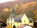
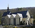
Deutsch: Katholische Wallfahrtskirche Maria im Grünen Tal. Dreischiffige Hallenkirche mit Zwerchgiebeln und eingezogenem 5/8-Chor sowie erhöhtem Chordach mit Zwiebelhauben-Dachreiter, westliche Giebelfassade mit zwei seitlichen polygonalen Treppentürmen mit Zwiebelhauben, gotischer Chor um 1340, Westfassade mit Türmen 17. Jahrhundert, Langhausneubau in angepasster Nachkriegsmoderne durch Hans Schädel 1969; mit Ausstattung.
Kapellenweg 2, Retzbach, Landkreis Main-Spessart, Unterfranken, Bayern, Deutschland
Kapellenweg 2, Retzbach, Landkreis Main-Spessart, Unterfranken, Bayern, Deutschland
cultural heritage monument D-6-77-203-86 (0) in Zellingen, Bavaria  .jpg) | |||||
| Upload media | |||||
| Instance of | |||||
|---|---|---|---|---|---|
| Location | Zellingen, Main-Spessart, Lower Franconia, Bavaria, Germany | ||||
| Street address |
| ||||
| Has part(s) |
| ||||
| Heritage designation | |||||
 | |||||
Subcategories
This category has the following 5 subcategories, out of 5 total.
F
- Friedhofskreuz (Retzbach) (2 F)
I
- Interior of Maria im Grünen Tal (18 F)
K
- Kapellenweg 3 Retzbach (7 F)
- Kreuzweg (Retzbach) (35 F)
M
- Mariensäule (Retzbach) (6 F)
Pages in category "Maria im Grünen Tal"
This category contains only the following page.
Media in category "Maria im Grünen Tal"
The following 24 files are in this category, out of 24 total.
-
 Kapellenweg 2 Pfeilerportal (Liebleinmühle).JPG 1,302 × 1,443; 759 KB
-
 Katholische Wallfahrtskirche Maria im Grünen Tal (Leibleinmühle).JPG 2,304 × 1,728; 1.84 MB
-
 Maria im grünen Tal-Retzbach (cropped).jpg 2,494 × 2,035; 532 KB
-
 Maria im grünen Tal-Retzbach.jpg 3,852 × 2,560; 1.36 MB
-
 Retzbach - Wallfahrtskirche Maria im grünen Tal - 1 (cropped).jpg 2,926 × 2,540; 5.16 MB
-
 Retzbach - Wallfahrtskirche Maria im grünen Tal - 1.jpg 4,823 × 3,215; 10 MB
-
 Retzbach - Wallfahrtskirche Maria im grünen Tal - 2.jpg 4,948 × 3,711; 10.35 MB
-
 Retzbach - Wallfahrtskirche Maria im grünen Tal - 3 - Blick zum alten Teil der Kirche.jpg 3,570 × 5,712; 11.35 MB
-
 Retzbach - Wallfahrtskirche Maria im grünen Tal - 4 - Turm am alten Teil der Kirche.jpg 3,498 × 5,247; 10.1 MB
-
-

-
 Retzbach Maria im grünen Tal.jpg 3,648 × 2,736; 4.56 MB
-
 Retzbach, D-6-77-203-86, Kath. Wallfahrtskirche Maria im Grünen Tal Zellingen 20221204 0159.jpg 4,024 × 6,048; 26.06 MB
-
 Retzbach, D-6-77-203-86, Kath. Wallfahrtskirche Maria im Grünen Tal Zellingen 20221204 0160.jpg 5,846 × 3,890; 18.67 MB
-
 Retzbach, D-6-77-203-86, Kath. Wallfahrtskirche Maria im Grünen Tal Zellingen 20221204 0161.jpg 5,678 × 3,778; 18.81 MB
-
 Retzbach, D-6-77-203-86, Pfeilerportal Zellingen 20221204 0153.jpg 5,755 × 3,830; 21.9 MB
-
 Retzbach, D-6-77-203-86, Pfeilerportal Zellingen 20221204 0154.jpg 3,696 × 5,556; 15.5 MB
-
 Retzbach, D-6-77-203-86, Pfeilerportal Zellingen 20221204 0155.jpg 3,427 × 5,151; 10.86 MB
-
 Retzbach, D-6-77-203-86, Pfeilerportal Zellingen 20221204 0156.jpg 4,024 × 6,048; 19.14 MB
-
 Retzbach, D-6-77-203-86, Pfeilerportal Zellingen 20221204 0157.jpg 5,864 × 3,902; 20.11 MB
-
 Retzbach, D-6-77-203-86, Pfeilerportal Zellingen 20221204 0158.jpg 5,684 × 3,782; 23.3 MB
-
 Retztal Marienbrünnle bei der Wallfahrtskirche August 2007 01.jpg 1,970 × 1,776; 1.01 MB
-
 Retztal Marienbrünnle bei der Wallfahrtskirche August 2007 02.jpg 2,560 × 1,920; 945 KB
-
 Zellingen, Markt Retzbach, Wallfahrtskirche Maria im Grünen Tal-001.jpg 4,928 × 3,264; 8.44 MB
.JPG)
.JPG)
.jpg)

.jpg)


