Category:Maria Bürg (Oberpöring)
Jump to navigation
Jump to search
This is the category of the Bavarian Baudenkmal (cultural heritage monument) with the ID D-2-71-139-6 (Wikidata)
|
| Object location | | View all coordinates using: OpenStreetMap |
|---|
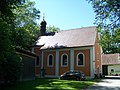
church building in Oberpöring, Lower Bavaria, Germany | |||||
| Upload media | |||||
| Instance of | |||||
|---|---|---|---|---|---|
| Location | Oberpöring, Deggendorf, Lower Bavaria, Bavaria, Germany | ||||
| Street address |
| ||||
| Heritage designation | |||||
 | |||||
Media in category "Maria Bürg (Oberpöring)"
The following 5 files are in this category, out of 5 total.
-
 Oberpöring-Maria-Bürg-Wallfahrtskirche-Hochaltar.jpg 3,264 × 2,448; 2.03 MB
-
 Oberpöring-Maria-Bürg-Wallfahrtskirche-Innenraum.jpg 3,264 × 2,448; 2.26 MB
-
 Oberpöring-Maria-Bürg-Wallfahrtskirche-Orgelempore.jpg 3,216 × 2,410; 1.6 MB
-
 Oberpöring-Maria-Bürg-Wallfahrtskirche-Portal.jpg 3,264 × 2,448; 1.63 MB
-
 Oberpöring-Maria-Bürg-Wallfahrtskirche.jpg 3,264 × 2,448; 1.98 MB


