Category:March 2007 in Herefordshire
Jump to navigation
Jump to search
Ceremonial counties of England: Bedfordshire · Berkshire · Buckinghamshire · Cambridgeshire · Cheshire · Cornwall · Cumbria · Derbyshire · Devon · Dorset · Durham · East Riding of Yorkshire · East Sussex · Essex · Gloucestershire · Greater London · Greater Manchester · Hampshire · Herefordshire · Hertfordshire · Isle of Wight · Kent · Lancashire · Leicestershire · Lincolnshire · Merseyside · Norfolk · North Yorkshire · Northamptonshire · Northumberland · Nottinghamshire · Oxfordshire · Rutland · Shropshire · Somerset · South Yorkshire · Staffordshire · Suffolk · Surrey · Tyne and Wear · Warwickshire · West Midlands · West Sussex · West Yorkshire · Wiltshire · Worcestershire
City-counties: Bristol ·
Former historic counties:
Other former counties:
City-counties: Bristol ·
Former historic counties:
Other former counties:
Deutsch: Bilder, die im März 2007 in Herefordshire aufgenommen worden sind. Bitte beachten Sie, dass dies weder das Datum des Uploads noch das Datum des Scannens eines Fotos ist.
English: Images/pictures taken in Herefordshire during March 2007. Note this is not the date of the upload, nor the date a photo was scanned.
Español: Fotografías o imágenes tomadas en Herefordshire durante marzo 2007. No es la fecha de subida ni escaneo, sino la fecha en que las fotografías o imágenes se crearon.
Esperanto: Bildoj faritaj en Herefordshire en marto 2007. Tio ne estas la dato, kiam la bildoj estis alŝutitaj aŭ skanitaj.
Français : Photographies ou images prises en Herefordshire durant mars 2007. Ce n'est pas la date du téléchargement ou du scan.
Galego: Fotografías ou imaxes tomadas en Herefordshire durante marzo 2007. Non é a data de subida nin escaneamento, senón a data na que se crearon as fotografías ou imaxes.
Italiano: Fotografie o immagini scattate a Herefordshire nel marzo 2007. Nota bene: la data non si riferisce né a quella di upload né a quella in cui la foto è stata digitalizzata.
Norsk bokmål: Bilder tatt i Herefordshire i løpet av mars 2007. Merk at dette ikke er datoen for opplasting, eller når et bilde har blitt skannet.
Norsk nynorsk: Bilete teke i Herefordshire i løpet av mars 2007. Merk at dette ikkje er datoen for opplasting, eller når eit bilete har vorte skanna.
Русский: Изображения, сделанные в Herefordshire в течение март 2007 (не дата загрузки изображения).
Українська: Зображення, зроблені в Herefordshire протягом березень 2007. Зауважте, що це не дата завантаження чи дата сканування фотографії.
| March 2006 | ← | March 2007 | → | March 2008 | |||||||
| Jan | Feb | Mar | Apr | May | Jun | Jul | Aug | Sep | Oct | Nov | Dec |
| 51 | 62 | 99 | 75 | 60 | 82 | 72 | 81 | 50 | 36 | 31 | 77 |
|---|---|---|---|---|---|---|---|---|---|---|---|
Media in category "March 2007 in Herefordshire"
The following 99 files are in this category, out of 99 total.
-
 'Hazeldene' - Shirl Heath, Herefordshire - geograph.org.uk - 365904.jpg 640 × 480; 127 KB
-
 Poolpardon Lane - geograph.org.uk - 486045.jpg 640 × 480; 146 KB
-
 The Rhydspence Inn - geograph.org.uk - 486226.jpg 640 × 480; 89 KB
-
 Abandoned cottage on Wormsley Hill - geograph.org.uk - 354331.jpg 640 × 426; 124 KB
-
 Farm driveway to Fenhampton - geograph.org.uk - 352348.jpg 640 × 426; 113 KB
-
 Footpath west to Bridge Sollers - geograph.org.uk - 362893.jpg 640 × 480; 98 KB
-
 Lane to Old Sutton - geograph.org.uk - 373640.jpg 640 × 480; 75 KB
-

-
 Park Stile Mill - geograph.org.uk - 376799.jpg 640 × 480; 90 KB
-
 Railway bridge over the river Lugg - geograph.org.uk - 457365.jpg 640 × 480; 152 KB
-
 Road to Huntington Court - geograph.org.uk - 486527.jpg 640 × 480; 102 KB
-
 Spring below Upper Castleton Farm - geograph.org.uk - 486000.jpg 640 × 480; 115 KB
-
 Station platform, Almeley - geograph.org.uk - 377604.jpg 640 × 462; 58 KB
-
 Sugwas Court - geograph.org.uk - 359041.jpg 640 × 480; 148 KB
-
 The Elder Tree Inn - geograph.org.uk - 363215.jpg 640 × 427; 67 KB
-
 Timber-framed cottage, Eardisland - geograph.org.uk - 364401.jpg 640 × 426; 126 KB
-
 Titley Junction - geograph.org.uk - 361213.jpg 640 × 480; 62 KB
-
 Trees on the skyline, Wormsley Hill - geograph.org.uk - 354321.jpg 640 × 426; 88 KB
-
 Cross at St. John's - geograph.org.uk - 467511.jpg 480 × 640; 126 KB
-
 Woods Eaves - geograph.org.uk - 486493.jpg 640 × 480; 88 KB
-
 Woods Eaves Farm - geograph.org.uk - 486494.jpg 640 × 480; 97 KB
-
 Remains of a cross, Wormsley - geograph.org.uk - 354956.jpg 640 × 426; 119 KB
-
 Wyevale Nurseries - geograph.org.uk - 373654.jpg 640 × 480; 53 KB
-
 Abandoned railway, Nextend - geograph.org.uk - 361241.jpg 640 × 480; 128 KB
-
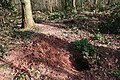 Badger Sett in Hall Wood - geograph.org.uk - 360305.jpg 640 × 427; 350 KB
-
 Barn at Cwmmau farm - geograph.org.uk - 376707.jpg 640 × 450; 76 KB
-
 Black and white cottage, at Woods Eaves - geograph.org.uk - 376444.jpg 480 × 640; 129 KB
-
 Brady cottage, Upper Marston - geograph.org.uk - 361287.jpg 640 × 480; 97 KB
-
 Bridge over Cradley Brook - geograph.org.uk - 374454.jpg 640 × 426; 103 KB
-
 Bridleway down to the river - geograph.org.uk - 378185.jpg 640 × 480; 118 KB
-
 Bridleway to Breinton Common - geograph.org.uk - 373506.jpg 640 × 480; 83 KB
-

-
 Bunshill Lane - geograph.org.uk - 373530.jpg 640 × 480; 74 KB
-
 Chickward - geograph.org.uk - 377491.jpg 640 × 480; 76 KB
-
 Children - geograph.org.uk - 361266.jpg 480 × 640; 156 KB
-
 Church Road, Eardisley - geograph.org.uk - 376327.jpg 640 × 480; 91 KB
-
 Crest of the hill - geograph.org.uk - 362869.jpg 640 × 480; 59 KB
-
 Daffodils in Hall Wood - geograph.org.uk - 360239.jpg 640 × 427; 349 KB
-
 Daren Brook - geograph.org.uk - 373458.jpg 480 × 640; 142 KB
-
 Empton Farm - geograph.org.uk - 376757.jpg 640 × 467; 70 KB
-
 Farm building at Ivington Park - geograph.org.uk - 365093.jpg 640 × 426; 128 KB
-
 Farm buildings at Cobnash - geograph.org.uk - 360849.jpg 640 × 426; 102 KB
-
 Fields east of Upper Breinton - geograph.org.uk - 373510.jpg 640 × 480; 57 KB
-

-
 Footpath through Garnstone Wood - geograph.org.uk - 352281.jpg 640 × 426; 163 KB
-

-
 Footpath to Didley - geograph.org.uk - 485979.jpg 640 × 480; 126 KB
-
 Footpath to Upper Breinton - geograph.org.uk - 359065.jpg 640 × 480; 83 KB
-
 Formerly, The Boat Inn - geograph.org.uk - 358584.jpg 480 × 640; 79 KB
-
 Formerly, The Boat Inn - geograph.org.uk - 358585.jpg 640 × 480; 131 KB
-
 Green lane - geograph.org.uk - 373495.jpg 640 × 480; 128 KB
-
 Green lane west to Newchurch - geograph.org.uk - 486501.jpg 640 × 480; 127 KB
-
 Hall Wood - Grazed Area - geograph.org.uk - 360280.jpg 640 × 405; 339 KB
-
 Hunton farm, Nextend - geograph.org.uk - 361218.jpg 640 × 480; 84 KB
-
 Ivingtonbury, Ivington - geograph.org.uk - 364439.jpg 640 × 426; 115 KB
-
 Lane by Clifford Place - geograph.org.uk - 378070.jpg 640 × 480; 109 KB
-
 Lane farm, near Brilley - geograph.org.uk - 376464.jpg 640 × 458; 56 KB
-
 Lane to the hill fort near Brierley - geograph.org.uk - 365110.jpg 640 × 426; 140 KB
-
 Larch "roses" - geograph.org.uk - 387694.jpg 640 × 480; 77 KB
-

-
 Lewis Wych - geograph.org.uk - 361250.jpg 640 × 480; 71 KB
-
 Mahollam Farm - geograph.org.uk - 376783.jpg 640 × 480; 115 KB
-
 Memorial Shelter, Midsummer Hill - geograph.org.uk - 372593.jpg 640 × 426; 105 KB
-
 Midsummer Hill - geograph.org.uk - 367293.jpg 640 × 426; 116 KB
-
 Midsummer Hill - geograph.org.uk - 367298.jpg 640 × 426; 141 KB
-

-

-

-
 Old Sunken Roadway near Hall Wood - geograph.org.uk - 360327.jpg 640 × 427; 319 KB
-
 Pasture land by Upper Castleton Farm - geograph.org.uk - 486040.jpg 640 × 480; 79 KB
-
 Path to Upper Hergest - geograph.org.uk - 377471.jpg 640 × 480; 109 KB
-
 Plane tree at Foxley - geograph.org.uk - 352210.jpg 426 × 640; 124 KB
-
 Railway bridge, Nextend - geograph.org.uk - 361221.jpg 640 × 480; 139 KB
-
 Red-brick barns at Upper Breinton - geograph.org.uk - 362875.jpg 640 × 480; 92 KB
-
 River Lugg in flood - geograph.org.uk - 457371.jpg 640 × 480; 121 KB
-
 Rolling countryside, Nextend - geograph.org.uk - 361268.jpg 640 × 480; 88 KB
-
 Roman Road at Bishopstone - geograph.org.uk - 373532.jpg 640 × 480; 78 KB
-
 Sherriff's farm - geograph.org.uk - 361274.jpg 640 × 466; 58 KB
-
 Shukes Bank - geograph.org.uk - 352295.jpg 640 × 426; 130 KB
-
 Spring floral display - geograph.org.uk - 378064.jpg 640 × 480; 123 KB
-
 Stagbatch House - geograph.org.uk - 360767 (cropped).jpg 313 × 313; 59 KB
-
 Stagbatch House - geograph.org.uk - 360767.jpg 640 × 426; 104 KB
-
 Stowe Farm - geograph.org.uk - 378177.jpg 640 × 480; 85 KB
-
 Stream at Woods Eaves - geograph.org.uk - 376449.jpg 640 × 480; 142 KB
-
 Sweet violets - geograph.org.uk - 387681.jpg 640 × 480; 85 KB
-
 The edge of Forest Wood - geograph.org.uk - 377476.jpg 640 × 480; 123 KB
-
 Track into Darkhill Wood, Yazor - geograph.org.uk - 353924.jpg 426 × 640; 161 KB
-
 Track through Garnstone Wood - geograph.org.uk - 352264.jpg 640 × 426; 127 KB
-
 Track through Gullet Wood - geograph.org.uk - 367304.jpg 426 × 640; 156 KB
-
 Track through Hall Wood - geograph.org.uk - 360257.jpg 640 × 427; 328 KB
-
 Track to Cwm Maddoc Farm - geograph.org.uk - 373480.jpg 640 × 480; 86 KB
-
 Track to Hill Top Farm on Wormsley Hill - geograph.org.uk - 353909.jpg 426 × 640; 131 KB
-
 Track to Marston farm - geograph.org.uk - 361280.jpg 640 × 480; 88 KB
-
 Track up Wormsley Hill - geograph.org.uk - 352790.jpg 426 × 640; 145 KB
-
 Two poplars - geograph.org.uk - 378027.jpg 640 × 480; 114 KB
-
 Uprooted tree, Sugwas Court - geograph.org.uk - 359047.jpg 640 × 480; 167 KB
-
 West Wood - geograph.org.uk - 373660.jpg 640 × 480; 71 KB
-
 Woodland in March - geograph.org.uk - 468364.jpg 640 × 480; 154 KB
-
 Woods Eaves - geograph.org.uk - 376441.jpg 640 × 480; 76 KB


.jpg)


