Category:Maps with links to NYPL Georeferencer
Jump to navigation
Jump to search
Media in category "Maps with links to NYPL Georeferencer"
The following 53 files are in this category, out of 53 total.
-
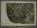 22C - N.Y. City (Aerial Set). NYPL1532644.tiff 7,230 × 5,428; 112.28 MB
-

-

-

-

-

-

-
-

-

-

-

-

-

-

-

-
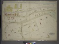
 Islip Village and Vicinity Suffolk County, N.Y. NYPL1602997.tiff 7,230 × 5,194; 107.44 MB
-
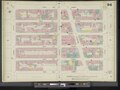
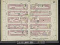
 Manhattan, V. 5, Double Page Plate No. 85 (Map bounded by W. 27th St., 6th Ave., W. 22nd St., 8th Ave.) NYPL2001707.tiff 8,977 × 6,727, 2 pages; 172.83 MB
-
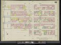
 Manhattan, V. 5, Double Page Plate No. 86 (Map bounded by W. 27th St., 8th Ave., W. 22nd St., 10th Ave.) NYPL2001708.tiff 8,896 × 6,666, 2 pages; 169.72 MB
-
 Manhattan, V. 5, Double Page Plate No. 87 (Map bounded by W. 27th St., 10th Ave., W. 22nd St., Hudson River) NYPL2001709.tiff 8,870 × 6,646, 2 pages; 168.72 MB
-
 Manhattan, V. 5, Double Page Plate No. 88 (Map bounded by W. 32nd St., 6th Ave., W. 27th St., 8th Ave.) NYPL2001710.tiff 8,975 × 6,726, 2 pages; 172.77 MB
-
 Manhattan, V. 5, Double Page Plate No. 89 (Map bounded by W. 32nd St., 8th Ave., W. 27th St., 10th Ave.) NYPL2001711.tiff 8,963 × 6,716, 2 pages; 172.28 MB
-
 Manhattan, V. 5, Double Page Plate No. 90 (Map bounded by W. 32nd St., 10th Ave., W. 27th St., Hudson River) NYPL2001712.tiff 8,949 × 6,706, 2 pages; 171.76 MB
-
 Manhattan, V. 5, Double Page Plate No. 91 (Map bounded by W. 37th St., 6th Ave., W. 32nd St., 8th Ave.) NYPL2001713.tiff 8,935 × 6,695, 2 pages; 171.21 MB
-
 Manhattan, V. 5, Double Page Plate No. 92 (Map bounded by W. 37th St., 8th Ave., W. 32nd St., 10th Ave.) NYPL2001714.tiff 8,963 × 6,716, 2 pages; 172.28 MB
-
 Manhattan, V. 5, Double Page Plate No. 93 (Map bounded by W. 37th St., 10th Ave., W. 32nd St., Hudson River) NYPL2001715.tiff 8,902 × 6,670, 2 pages; 169.94 MB
-
 Manhattan, V. 5, Double Page Plate No. 94 (Map bounded by W. 42nd St., 6th Ave., W. 37th St., 8th Ave.) NYPL2001716.tiff 8,971 × 6,722, 2 pages; 172.59 MB
-
 Manhattan, V. 5, Double Page Plate No. 95 (Map bounded by W. 42nd St., 8th Ave., W. 37th St., 10th Ave.) NYPL2001717.tiff 8,971 × 6,722, 2 pages; 172.59 MB
-
 Manhattan, V. 5, Double Page Plate No. 96 (Map bounded by W. 42nd St., 10th Ave., W. 37th St., Hudson River) NYPL2001718.tiff 8,971 × 6,722, 2 pages; 172.59 MB
-
 Manhattan, V. 5, Double Page Plate No. 97 (Map bounded by W. 47th St., 6th Ave., W. 42nd St., 8th Ave.) NYPL2001719.tiff 8,956 × 6,711, 2 pages; 172.02 MB
-
 Manhattan, V. 5, Double Page Plate No. 98 (Map bounded by W. 47th St., 8th Ave., W. 42nd St., 10th Ave.) NYPL2001720.tiff 8,961 × 6,715, 2 pages; 172.22 MB
-
 Manhattan, V. 5, Double Page Plate No. 99 (Map bounded by W. 47th St., 10th Ave., W. 42nd St., Hudson River) NYPL2001721.tiff 8,971 × 6,722, 2 pages; 172.59 MB
-
 Manhattan, V. 5, Double Page Plate No. 100 (Map bounded by W. 52nd St., 6th Ave., W. 47th St., 8th Ave.) NYPL2001722.tiff 8,931 × 6,692, 2 pages; 171.05 MB
-
 Manhattan, V. 5, Double Page Plate No. 101 (Map bounded by W. 52nd St., 8th Ave., W. 47th St., 10th Ave.) NYPL2001723.tiff 8,953 × 6,709, 2 pages; 171.91 MB
-
 Manhattan, V. 5, Double Page Plate No. 102 (Map bounded by W. 52nd St., 10th Ave., W. 47th St., 12th Ave.) NYPL2001724.tiff 8,953 × 6,709, 2 pages; 171.91 MB
-
 Manhattan, V. 6, Double Page Plate No. 118 (Map bounded by W. 67th St., 5th Ave., E. 62nd St., 3rd Ave.) NYPL1992789.tiff 7,185 × 5,396, 2 pages; 110.98 MB
-
 Manhattan, V. 6, Double Page Plate No. 119 (Map bounded by E. 67th St., 1st Ave., E. 62nd St., 3rd Ave.) NYPL1992790.tiff 7,185 × 5,396, 2 pages; 110.98 MB
-
 Manhattan, V. 6, Double Page Plate No. 120 (Map bounded by 1st Ave., E. 72nd St., East River, E. 63rd St.) NYPL1992791.tiff 7,131 × 5,367, 2 pages; 109.56 MB
-
 Manhattan, V. 6, Double Page Plate No. 121 (Map bounded by E. 72nd St., 1st Ave., E. 67th St., 3rd Ave.) NYPL1992792.tiff 7,131 × 5,367, 2 pages; 109.56 MB
-
 Newengland and New York. NYPL433720.tiff 2,068 × 2,320; 13.73 MB
-

-
 Orsova und Turnu-Severin. NYPL1226950.tiff 4,360 × 5,235; 65.31 MB
-

-
 Queens V. 10, Plate No. 73 (Map bounded by Hanover Ave., Maurice Ave., Chicago St., Corona Ave.) NYPL1957031.tiff 5,408 × 7,207, 2 pages; 111.57 MB
-
 Queens V. 2, Plate No. 53 (Map bounded by Astoria Light, Heat and Power Co. Gas Plant) NYPL1954667.tiff 5,412 × 7,216, 2 pages; 111.79 MB
-

-

-

-

-
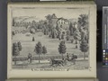 Res. of B. F. Dunning, Warwick, N.Y. NYPL1652190.tiff 7,230 × 5,428; 112.28 MB
-
 Residence of Edwin Parmelee, Bullville, Orange Co., N.Y. NYPL1652191.tiff 7,230 × 5,428; 112.28 MB
-

-
