Category:Maps showing 1956
Jump to navigation
Jump to search
| ← 1950 1951 1952 1953 1954 1955 1956 1957 1958 1959→ |
English: Maps showing the year 1956 (i.e. history maps)
See also category: 1956 maps. and 1950s maps for more maps showing this year usually created not long after the given year.
See also category: 1956 maps. and 1950s maps for more maps showing this year usually created not long after the given year.
Subcategories
This category has only the following subcategory.
Media in category "Maps showing 1956"
The following 5 files are in this category, out of 5 total.
-
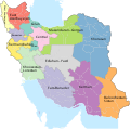 Iran provinces and counties 1956 English.svg 2,074 × 2,059; 357 KB
-
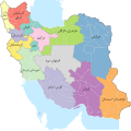 Iran provinces and counties 1956.svg 2,074 × 2,059; 364 KB
-
 Pirin 1956.png 1,024 × 768; 172 KB
-
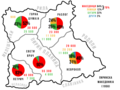
 Pirin Macedonians in 1956 census.jpg 741 × 556; 86 KB
-
 מבצע קדש- מפה.jpg 250 × 310; 74 KB


