Category:Maps showing 1813
Jump to navigation
Jump to search
| ← 1810 1811 1812 1813 1814 1815 1816 1817 1818 1819→ |
English: Maps showing the year 1813 (i.e. history maps)
See also category: 1813 maps. and 1810s maps for more maps showing this year usually created not long after the given year.
See also category: 1813 maps. and 1810s maps for more maps showing this year usually created not long after the given year.
Media in category "Maps showing 1813"
The following 7 files are in this category, out of 7 total.
-
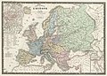 Europe 1813.jpg 8,489 × 6,108; 9.28 MB
-
 Frankreich BV042513016 (cropped).jpg 1,978 × 1,324; 309 KB
-
 Frankreich BV042513021 (cropped).jpg 1,999 × 1,373; 344 KB
-
 Frankreich BV042528185 (cropped).jpg 2,004 × 1,315; 412 KB
-
 Frankreich BV043419594 (cropped).jpg 2,010 × 2,670; 618 KB
-
 Frankreich BV043419720 (cropped).jpg 1,998 × 1,372; 264 KB
-
 Frankreich BV043557996 (cropped).jpg 1,991 × 1,471; 246 KB

.jpg)
.jpg)
.jpg)
.jpg)
.jpg)
.jpg)