Category:Maps related to Tawang
Jump to navigation
Jump to search
Media in category "Maps related to Tawang"
The following 14 files are in this category, out of 14 total.
-
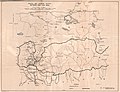 1903 Routes between Tibet and India by O'Connor.jpg 6,340 × 4,888; 1.56 MB
-
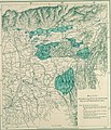
 1965 Relief map of Bhutan. 3-65. LOC 75695011 (cropped).tif 6,466 × 3,664; 67.78 MB
-
 2015 map detail, Bhutan Physiography (cropped).jpg 2,500 × 1,440; 699 KB
-
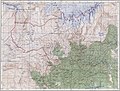
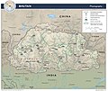 Bhutan Physiography.jpg 2,632 × 2,215; 948 KB
-
 Bhutan. 3-65. LOC 75695011.tif 6,864 × 4,150; 81.5 MB
-

-
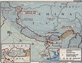
 MacMahon Line.jpg 750 × 528; 46 KB
-
-

-
 McMahon Line Simla Accord Treaty 1914 Map1.jpg 3,595 × 2,640; 2.46 MB
-
-
 Tawang Monyul region from 1936 Survey of India map.jpg 1,293 × 1,045; 605 KB
-
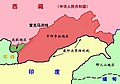
 Tibetischer Kulturraum Karte 2.png 1,500 × 951; 454 KB
-

.jpg)

_north_east.jpg)

.jpg)


.jpg)