Category:Maps of weather in 2003
Jump to navigation
Jump to search
Please sort by date, if specified
[[Maps of weather in 2003|MMDDhhmm]](in UTC)- take
*for complete year,MM-MMorMMDD-DDfor spans
Subcategories
This category has only the following subcategory.
P
Media in category "Maps of weather in 2003"
The following 12 files are in this category, out of 12 total.
-
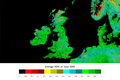
 2003 europe summer temperature anomaly.png 985 × 672; 366 KB
-
 Efemérides de noches tropicales verano 2003.png 500 × 353; 27 KB
-
 Ceres 2003 2004 clear sky total sky albedo.png 2,075 × 2,740; 1.58 MB
-
 Satellite image of Azerbaijan in March 2003.jpg 2,002 × 1,593; 526 KB
-
 NDVI 062003.png 2,052 × 1,364; 480 KB
-
 Temperature massime 2003.gif 972 × 1,129; 192 KB
-
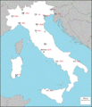
 Canicule Europe 2003.jpg 2,124 × 1,800; 1.38 MB
-
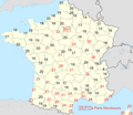 Température minimale le 12 août 2003 (le plus chaud de l'année) en France.png 1,104 × 957; 303 KB
-
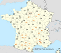 Températures maximales le 12 août 2003 (le plus chaud de l'année) en France.png 1,105 × 968; 309 KB
-
 NDVI 102003.png 2,052 × 1,364; 504 KB
-
CO2 concentrations.ogv 20 s, 960 × 540; 2.49 MB
-
Wind vectors and monthly average CO2 concentrations in 2003.ogv 20 s, 960 × 540; 3.78 MB


_en_France.png)
_en_France.png)
