Category:Maps of the territorial evolution of Utah
Jump to navigation
Jump to search
States of the United States: California · Utah
Media in category "Maps of the territorial evolution of Utah"
The following 15 files are in this category, out of 15 total.
-

-
 State of Deseret, vector image - 2011.svg 371 × 398; 19 KB
-
 State of Deseret, vector image cropped - 2011.svg 320 × 310; 29 KB
-
 Utah Territory with Deseret Border, vector image - 2011.svg 320 × 310; 29 KB
-
 Evolution of borders at Four Corners, USA - June 2013.gif 1,000 × 758; 617 KB
-
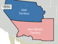
 Utah Territory Evolution - 1850, vector image - 2011.svg 280 × 220; 33 KB
-
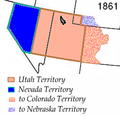
 Utah Territory Evolution - 1861, vector image - 2011.svg 280 × 220; 88 KB
-
 Utah Territory Evolution - 1862, vector image - 2011.svg 280 × 220; 41 KB
-
 Utah Territory Evolution - 1866, vector image - 2011.svg 280 × 220; 35 KB
-
 Utah Territory Evolution - 1868, vector image - 2011.svg 280 × 220; 41 KB
-
 Utah Territory Evolution - 1868-1896, vector image - 2011.svg 280 × 220; 88 KB
-
 Utah Territory evolution animation - August 2011.gif 1,000 × 786; 158 KB
-
 Vision vs. Reality sign at Utah Territorial Statehouse, Oct 16.jpg 2,592 × 1,944; 2.49 MB
-
 Wpdms deseret utah territory legend.png 300 × 360; 67 KB
-
 Wpdms utah territory 1861.png 255 × 247; 32 KB


