Category:Maps of the enceinte of Philippe-Auguste
Jump to navigation
Jump to search
Subcategories
This category has only the following subcategory.
Media in category "Maps of the enceinte of Philippe-Auguste"
The following 28 files are in this category, out of 28 total.
-
 Paris - Grande Gouache - Détail - 1532 - 001.jpg 4,252 × 7,596; 23.65 MB
-

-

-

-
-
-

-
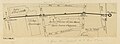
 Enceinte de Philippe Auguste. Rive gauche n°39. D.8021(1481)(2).jpg 3,000 × 897; 349 KB
-
 Henri Dron & Heymann, Plan de la Commune de Paris - Paris Musées.jpg 7,790 × 6,029; 29.14 MB
-
 P1280651 Paris V ancien couvent St-Jacques rwk.jpg 2,000 × 1,795; 1.72 MB
-
 P1280651 Paris V ancienne porte St-Jacques rwk.jpg 1,500 × 928; 1.31 MB
-
 P1280651 Paris V enceinte PA rwk.jpg 2,200 × 1,481; 2.48 MB
-
 Plan de Paris vers 1300-1330 - ALPAGE.svg 2,430 × 2,506; 443 KB
-
 Plan de Paris vers 1300-1330.svg 546 × 692; 408 KB
-
 Plan des anciennes enceintes de Paris (1180-1845) - Paris Musées.jpg 9,262 × 6,876; 40.55 MB
-

-
 Plan des anciennes enceintes et limites de Paris, Etabli par A. Grimault (02) - Paris Musées.jpg 8,463 × 6,108; 31.94 MB
-
 Plan des anciennes enceintes et limites de Paris, Etabli par A. Grimault (03) - Paris Musées.jpg 8,216 × 6,152; 32.71 MB
-
 Plan restitué de Paris en 1380 - ALPAGE.svg 2,403 × 2,570; 511 KB
-
 Plan restitué de Paris en 1380.svg 544 × 689; 460 KB
-
 The city limits of Paris from the 4th century to 2015.svg 1,500 × 1,000; 24 KB
-
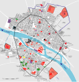
 Tracé de l'enceinte de Philippe Auguste - ALPAGE.svg 1,467 × 1,070; 820 KB
-
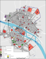
 Tracé de l'enceinte de Philippe Auguste - H. Noizet, A.-L. Bethe.svg 1,456 × 1,059; 1.04 MB
-
 Vieux Paris et ses monuments - Norman B. Leventhal Map Center.jpg 5,970 × 4,876; 6.4 MB
-
 Wall of Charles V - ALPAGE.pdf 2,700 × 2,700; 3.2 MB
-
 Wall of Charles V - ALPAGE.svg 512 × 364; 2.22 MB
-
 Wall of Charles V - OSM 2020.svg 2,200 × 1,600; 4.08 MB
-
 Wall of Philip II Augustus - OSM 2020.svg 1,500 × 1,300; 2.23 MB


(2).jpg)


_-_Paris_Mus%C3%A9es.jpg)
_-_Paris_Mus%C3%A9es.jpg)
_-_Paris_Mus%C3%A9es.jpg)
_-_Paris_Mus%C3%A9es.jpg)


(2).jpg)
(2).jpg)
(2).jpg)