Category:Maps of the current European Union with the United Kingdom
Jump to navigation
Jump to search
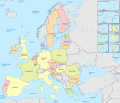
This category is for maps that are intended to depict the current European Union, or maps of the European Union from 1 February 2020 onwards, that still include the United Kingdom. Older maps of the European Union should not be included here.
Media in category "Maps of the current European Union with the United Kingdom"
The following 4 files are in this category, out of 4 total.
-
-
 European Union (+integral overseas), administrative divisions - de - colored.svg 1,401 × 1,198; 4.27 MB
-
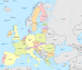 European Union, administrative divisions - de - colored.svg 1,401 × 1,198; 4.28 MB
-
 European Union, administrative divisions - Nmbrs - colored.svg 1,401 × 1,198; 4.26 MB
,_administrative_divisions_-_de_-_colored_(EU_labeled).svg)
,_administrative_divisions_-_de_-_colored.svg)

