Category:Maps of the Urban Villages of Phoenix, Arizona
Jump to navigation
Jump to search
English: Maps of the Urban Villages within the City of Phoenix.
- Unincorporated community sections are located in Maricopa County, Arizona.

| NO WIKIDATA ID FOUND! Search for Maps of the Urban Villages of Phoenix, Arizona on Wikidata | |
| Upload media |
- These maps are based on the Phoenix Urban Village Planners Map, located on the City of Phoenix Website.
The gray maps are variations of the colored map shown above.
Media in category "Maps of the Urban Villages of Phoenix, Arizona"
The following 16 files are in this category, out of 16 total.
-
 Phoenix Urban Villages.svg 502 × 1,005; 34 KB
-
 Phoenix Urban Villages Ahwatukee Foothills highlighted.svg 500 × 1,000; 112 KB
-
 Phoenix Urban Villages Alhambra highlighted.svg 500 × 1,000; 112 KB
-
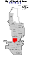
 Phoenix Urban Villages Camelback East highlighted.svg 500 × 1,000; 112 KB
-
 Phoenix Urban Villages Central City highlighted.svg 500 × 1,000; 112 KB
-
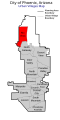
 Phoenix Urban Villages Deer Valley highlighted.svg 500 × 1,000; 112 KB
-
 Phoenix Urban Villages Desert View highlighted.svg 500 × 1,000; 112 KB
-
 Phoenix Urban Villages Encanto highlighted.svg 500 × 1,000; 112 KB
-
 Phoenix Urban Villages Estrella highlighted.svg 500 × 1,000; 112 KB
-
 Phoenix Urban Villages Laveen highlighted.svg 500 × 1,000; 112 KB
-
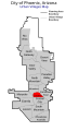
 Phoenix Urban Villages Maryvale highlighted.svg 500 × 1,000; 112 KB
-
 Phoenix Urban Villages North Gateway highlighted.svg 500 × 1,000; 112 KB
-
 Phoenix Urban Villages North Mountain highlighted.svg 500 × 1,000; 112 KB
-
 Phoenix Urban Villages Paradise Valley highlighted.svg 500 × 1,000; 112 KB
-
 Phoenix Urban Villages Rio Vista highlighted.svg 500 × 1,000; 112 KB
-
 Phoenix Urban Villages South Mountain highlighted.svg 500 × 1,000; 112 KB


