Category:Maps of the Upper West Side, Buffalo, New York
Jump to navigation
Jump to search
Media in category "Maps of the Upper West Side, Buffalo, New York"
The following 3 files are in this category, out of 3 total.
-
 Buffalo, Double Page Plate No. 20 (Map bounded by Porter Ave., Niagara River, Ferry St.) NYPL2055436.tiff 7,102 × 5,327, 2 pages; 108.5 MB
-
 Buffalo, Double Page Plate No. 21 (Map bounded by Niagara River, Bradley St., Tryon Pl., Ferry St.) NYPL2055437.tiff 7,062 × 5,297, 2 pages; 107.29 MB
-
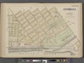
 Buffalo, V. 1, Double Page Plate No.27 (Map bounded by Niagara River, Bird Ave., Grant St., Hampshire St.) NYPL2056910.tiff 7,057 × 5,292, 2 pages; 107.11 MB