Category:Maps of the Tōkaidō (road)
Jump to navigation
Jump to search
Subcategories
This category has the following 7 subcategories, out of 7 total.
T
- Tokaido bunken nobe ezu (3 F)
- Tokaido Panorama Map (2 F)
木
- 木曾海道宿付 (1 F)
Media in category "Maps of the Tōkaidō (road)"
The following 7 files are in this category, out of 7 total.
-
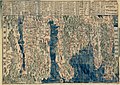 Itinerary map of the Tōkaidō Highway (14307715866).jpg 2,000 × 1,416; 1.7 MB
-
 Itinerary map of the Tōkaidō Highway (14330987955).jpg 1,129 × 2,500; 1.61 MB
-
 本坂通と東海道.png 1,088 × 972; 157 KB
-
 東海道.svg 512 × 256; 14 KB
-
 浜名湖周辺の状況(江戸時代).jpg 482 × 426; 55 KB
-
 浜名湖周辺の状況(江戸時代)2.jpg 1,436 × 1,421; 259 KB
-
 箱根関と東海道・脇往還.jpg 1,933 × 1,842; 455 KB
.jpg)
.jpg)


