Category:Maps of the Strait of Dover
Jump to navigation
Jump to search
Media in category "Maps of the Strait of Dover"
The following 23 files are in this category, out of 23 total.
-
 LondonCalaisParis.png 1,229 × 789; 1.43 MB
-
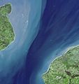 Dover AST 2001073 lrg.jpg 3,960 × 4,210; 1.61 MB
-
 Admiralty Chart No 1406 Dover and Calais to Orfordness and Scheveningen, Published 1906.jpg 16,332 × 11,290; 57.9 MB
-
 Admiralty Chart No 1431 Approaches to Dover Strait, Published 1915.jpg 11,287 × 17,535; 59.67 MB
-
 Admiralty Chart No 1892 Dover and Folkestone to Calais and Boulogne, Published 1971.jpg 16,459 × 11,320; 36.42 MB
-
 Admiralty Chart No 1895 Dover Strait, Published 1875 New Edition 1928.jpg 11,091 × 16,262; 40.92 MB
-
 Admiralty Chart No 1895 Dover Strait, Published 1959.jpg 16,195 × 11,086; 63.84 MB
-

-
 Admiralty Chart No 2148 Cayeux to Boulogne, Published 1894, Large Corrections, 1937.jpg 11,088 × 16,287; 53.43 MB
-
 Admiralty Chart No 2339 North Sea, Published 1913.jpg 11,086 × 16,185; 68.99 MB
-
 Admiralty Chart No 2612 Fecamp to Dover, Published 1894, Large Corrections 1946.jpg 11,306 × 20,632; 31.24 MB
-
 Admiralty Chart No 323 Calais to Dunkerque, Published 1940.jpg 16,460 × 11,332; 48.59 MB
-
 AdmoraltyvChart No 5059 Straits of Dover Co-tidal and Tidal Stream Chart, Published 1943.jpg 16,407 × 11,265; 45.28 MB
-
 Dover-Calais (2).jpg 4,592 × 3,424; 1.86 MB
-
 Dunkirk Evacuation shipping routes.png 1,000 × 751; 182 KB
-
 FMIB 43891 Straits of Dover.jpeg 2,151 × 1,567; 470 KB
-
 FMIB 49950 Vertical Section of the Straits of Dover.jpeg 754 × 307; 40 KB
-
 France & Colonies-1894-Pas de Calais.jpg 4,480 × 4,056; 3.6 MB
-
 Map of the English Channel and coasts.png 1,000 × 751; 168 KB
-
 Nordsee.jpg 4,004 × 4,549; 6.09 MB
-
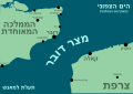 Strait of dover he.svg 3,455 × 2,429; 1.09 MB
-
 Strait of Dover map mk.svg 857 × 643; 487 KB
-
 Strait of Dover map.png 1,000 × 751; 187 KB


.jpg)


