Category:Maps of the Saronic Gulf
Jump to navigation
Jump to search
Subcategories
This category has only the following subcategory.
T
Media in category "Maps of the Saronic Gulf"
The following 19 files are in this category, out of 19 total.
-
 Golfe d'Engia Saronicus Sinus - Peeters Jacob - 1690.jpg 1,500 × 994; 780 KB
-
 Admiralty Chart No 1657 Greece, Gulf of Athens, Published 1892.jpg 12,484 × 8,375; 11.66 MB
-
 Admiralty Chart No 1657 Saronikos Kolpos, Published 1963.jpg 16,178 × 11,065; 39.7 MB
-
 Admiralty Chart No 1518 Argolikόs Kόlpos to Nisís Áyios Yeόryios, Published 1966.jpg 19,942 × 11,236; 42.03 MB
-
 Admiralty Chart No 1520 Piraieus and Ormos Falirou, Published 1961.jpg 16,199 × 11,064; 39.1 MB
-
 Diapories islands.JPG 819 × 573; 31 KB
-
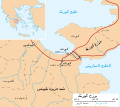 Isthmus of Corinth-ar.svg 672 × 600; 144 KB
-
 Isthmus of Corinth-es.svg 672 × 600; 250 KB
-
 Isthmus of Corinth.svg 672 × 600; 117 KB
-
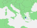 Locatie Golf van Egina.PNG 478 × 365; 14 KB
-
 Megara Gulf.jpg 902 × 495; 76 KB
-
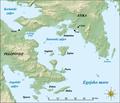
 Saronic Gulf map-de.svg 1,490 × 1,280; 808 KB
-
 Saronic Gulf map-es.svg 1,490 × 1,280; 921 KB
-
 Saronic Gulf map-fr.svg 1,490 × 1,280; 808 KB
-
 Saronic Gulf map-hr.pdf 2,483 × 2,133; 2.02 MB
-
 Saronic Gulf map-hu.svg 1,490 × 1,280; 808 KB
-
 Saronic Gulf map-la.svg 1,490 × 1,280; 801 KB
-
 Saronic Gulf map-mk.svg 1,490 × 1,280; 883 KB
-
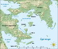
 Saronic Gulf.png 200 × 204; 16 KB


