Category:Maps of the Roman Empire in 271 AD
Jump to navigation
Jump to search
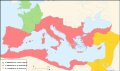
This category contains maps depicting the three-fold division of the Roman world into the Roman Empire proper, the "Gallic Empire" and the "Palmyrene Empire", at the time of the accession of Emperor Aurelian in 270/271 AD.
Media in category "Maps of the Roman Empire in 271 AD"
The following 19 files are in this category, out of 19 total.
-
 Carte division des empires.jpg 800 × 473; 48 KB
-
 Carte empire Romain 271-es.svg 2,050 × 1,213; 370 KB
-
 Carte empire Romain 271.svg 2,050 × 1,213; 385 KB
-
 Map of Ancient Rome 271 AD ca.svg 2,050 × 1,213; 396 KB
-
 Map of Ancient Rome 271 AD fi.svg 2,050 × 1,213; 385 KB
-
 Map of Ancient Rome 271 AD heb.png 2,050 × 1,213; 320 KB
-
 Map of Ancient Rome 271 AD hr.svg 2,050 × 1,213; 385 KB
-
 Map of Ancient Rome 271 AD la.svg 2,050 × 1,213; 385 KB
-
 Map of Ancient Rome 271 AD pl.svg 2,050 × 1,213; 374 KB
-
 Map of Ancient Rome 271 AD-ar.svg 800 × 473; 174 KB
-
 Map of Ancient Rome 271 AD-hu.svg 2,050 × 1,213; 387 KB
-
 Map of Ancient Rome 271 AD-id.svg 2,050 × 1,213; 207 KB
-
 Map of Ancient Rome 271 AD-pt.svg 2,050 × 1,213; 208 KB
-
 Map of Ancient Rome 271 AD-ru.svg 7,272 × 4,321; 307 KB
-
 Map of Ancient Rome 271 AD-sr.svg 2,050 × 1,213; 396 KB
-
 Map of Ancient Rome 271 AD.svg 2,050 × 1,213; 207 KB
-
 Mapa Imperio romano Aureliano siglo III d.C.png 3,000 × 1,856; 7.68 MB
-
 Romanworld271AD (hy).png 524 × 377; 197 KB
-
 Romanworld271AD-zh-classical.png 524 × 377; 206 KB


.png)
