Category:Maps of the Ottoman Empire in the 18th century
Jump to navigation
Jump to search
English: This category is about history maps on the subject. Old maps belong into: Category:18th-century maps of the Ottoman Empire and its subcategories.
Subcategories
This category has the following 9 subcategories, out of 9 total.
.
Media in category "Maps of the Ottoman Empire in the 18th century"
The following 36 files are in this category, out of 36 total.
-
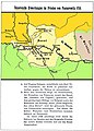
 1735-1739 Osmanli-Rus Savasi.PNG 975 × 700; 56 KB
-
 Af.Est 1700.png 1,720 × 1,830; 638 KB
-
 Albanian Pashaliks, 1790-1795.png 2,699 × 2,956; 3.23 MB
-
 Belgrade pashaluk BG.png 756 × 552; 28 KB
-
 Belgrade pashaluk-ar.png 836 × 481; 42 KB
-
 Belgrade pashaluk.png 863 × 670; 69 KB
-
 Belgrade pashaluk mk.png 865 × 500; 41 KB
-
 BajalatoDeBelgrado.svg 842 × 484; 172 KB
-
 Belgrádi pasalik.png 756 × 552; 15 KB
-
 Egypt and Syria 1768 to 1774 map ar.png 2,792 × 2,172; 778 KB
-
 Egypt and Syria 1768 to 1774 map de.png 2,792 × 2,172; 874 KB
-
 Egypt and Syria 1768 to 1774 map en.png 2,792 × 2,172; 873 KB
-
 Egypt and Syria 1775 to 1805 map de.png 2,792 × 2,172; 835 KB
-
 Eyalet of Algéria in the 1700.png 8,234 × 4,096; 1.06 MB
-
 Damascus Eyalet, Ottoman Empire (1795).png 2,434 × 2,037; 591 KB
-
 Jeddah Eyalet, Ottoman Empire (1795).png 2,434 × 2,037; 592 KB
-
 Ottoman Empire (1795).png 2,340 × 1,975; 826 KB
-
 Sidon Eyalet, Ottoman Empire (1795).png 2,434 × 2,037; 590 KB
-
 오스만 제국 (1795년).Png 2,434 × 2,037; 1.28 MB
-
 Les provinces de la Régence d'Alger en 1700.png 8,234 × 4,096; 1.09 MB
-
 Lokale Machtzentren in Anatolien 18-19 Jh.jpg 2,009 × 1,126; 477 KB
-
 Map of the Russo-Turkish War (1768–1774) and Orlov Revolt (1770)-hu.svg 1,149 × 822; 1.07 MB
-
 Map of the Russo-Turkish War (1768–1774) and Orlov Revolt (1770).svg 1,149 × 822; 1.07 MB
-
 Passarowitz 1718.JPG 1,200 × 1,681; 977 KB
-
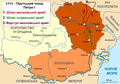 Prut pohod in 1711-uk.png 2,446 × 1,721; 469 KB
-
 Prutin sotaretki 1711-b.png 2,000 × 1,407; 438 KB
-
 Regency of Algiers 15th-18th Century.jpg 2,250 × 1,974; 1.34 MB
-
 Regionale Machtzentren in Anatolien im 18 u 19 Jh.jpg 2,009 × 1,126; 619 KB
-
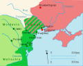
 1787-1792 Osmanli-Rus Savasi.PNG 1,000 × 800; 67 KB
-
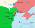
 Russo-Turkish war, 1787-1792.svg 550 × 436; 82 KB
-
 Russo-Turkish war, 1787-1792 no.svg 550 × 436; 12 KB
-
 Southeast Europe, 1714.PNG 737 × 647; 361 KB
-
 Srbsko Ottoman XVIII-es.svg 792 × 1,019; 131 KB
-
 Srbsko Ottoman XVIII.svg 792 × 1,019; 131 KB
-
 Zahir al-Umar maximum extent map-es.svg 524 × 860; 727 KB
-
 Zahir al-Umar maximum extent map.svg 552 × 905; 80 KB


.png)
.png)
.png)
.png)
.Png)


_and_Orlov_Revolt_(1770)-hu.svg)
_and_Orlov_Revolt_(1770).svg)


