Category:Maps of the Nelson River
Jump to navigation
Jump to search
Media in category "Maps of the Nelson River"
The following 9 files are in this category, out of 9 total.
-

-
 A Draught of Nelson & Hayes's Rivers (1752).jpg 7,045 × 2,813; 3.47 MB
-
 A Section of the Map of North America (Aaron Arrowsmith 1802).jpg 6,664 × 6,062; 4.68 MB
-
 A Section of the Map of the Map of North America (Aaron Arrowsmith 1814).jpg 8,101 × 7,577; 6.16 MB
-
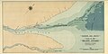 Hudson Bay Route Plan of the Nelson Estuary (1927).jpg 7,516 × 3,784; 10.55 MB
-
-
 Map of the mouths of the Nelson, Hayes and Fourteen Rivers (1912).jpg 3,581 × 2,051; 3.42 MB
-
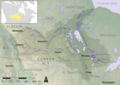 Nelson river basin map.png 1,200 × 848; 1.72 MB
-
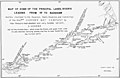
 The Pas to Port Nelson (1938) (2948703455).jpg 8,981 × 2,374; 3.73 MB
%27_(11166453246).jpg)
.jpg)
.jpg)
.jpg)
.jpg)
.jpg)

.jpg)
_(2948703455).jpg)