Category:Maps of the London Borough of Hackney
Jump to navigation
Jump to search
Media in category "Maps of the London Borough of Hackney"
The following 12 files are in this category, out of 12 total.
-
 Abney Park Section Map.jpg 2,540 × 2,306; 693 KB
-
 Barbican area map with stations and hotels.png 1,281 × 798; 1.01 MB
-
 ELondon.PNG 254 × 368; 11 KB
-
 Hackney districts.gif 250 × 259; 21 KB
-
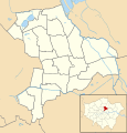 Hackney London UK 2014 blank ward map.svg 1,218 × 1,266; 343 KB
-
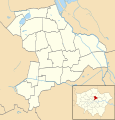 Hackney London UK blank ward map.svg 1,218 × 1,266; 318 KB
-
 Hackney London UK labelled ward map 2002-2014.svg 1,112 × 1,266; 66 KB
-
 Hackney London UK location map.svg 1,218 × 1,266; 2.33 MB
-
 Hackney Met. B Ward Map 1916.svg 1,010 × 1,088; 73 KB
-
 Hackney UK locator map.svg 1,425 × 1,140; 1.06 MB
-
 LondonHackney.svg 962 × 744; 19 KB
-
 Stoke Newington Met. B Ward Map 1916.svg 687 × 1,052; 38 KB


