Category:Maps of the Koshikijima Islands
Jump to navigation
Jump to search
Media in category "Maps of the Koshikijima Islands"
The following 11 files are in this category, out of 11 total.
-
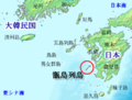
 Koshikijima Islands Kagoshima Prefecture.png 475 × 325; 5 KB
-
 Koshikijima Islands.png 425 × 322; 83 KB
-
 Koshikijima Map ja.png 899 × 1,040; 71 KB
-
 Koshikijima-rettō map.jpg 1,122 × 955; 428 KB
-
 Koshikishima 2019.png 1,092 × 993; 141 KB
-
 Koshikishima 2020.jpg 1,080 × 1,040; 79 KB
-
 Koshikishima Islands.png 522 × 513; 137 KB
-
 Koshikishima Oaza Map ja.svg 839 × 901; 21 KB
-
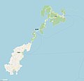
 Location of Kamikoshiki, Kagoshima, Japan.svg 395 × 777; 260 KB
-
 Location of Shimokoshiki, Kagoshima, Japan.svg 395 × 777; 260 KB
-
 Southern kyushu with adjacent islands.png 1,799 × 1,380; 720 KB


