Category:Maps of the Isle of Skye
Jump to navigation
Jump to search
Subcategories
This category has the following 2 subcategories, out of 2 total.
O
- Old maps of the Isle of Skye (22 F)
Media in category "Maps of the Isle of Skye"
The following 38 files are in this category, out of 38 total.
-
 171 of '(Our own country. Descriptive, historical, pictorial.)' (11245177623).jpg 1,321 × 1,680; 639 KB
-
 Admiralty Chart No 1795 Little Minch, Published 1958, New Edition 1973.jpg 11,249 × 16,472; 18.69 MB
-
 Admiralty Chart No 1795 The Little Minch - southern part, Published 1958.jpg 6,816 × 9,845; 23.73 MB
-
 Admiralty Chart No 2498 Sound of Raasay and Inner Sound, Published 1961.jpg 12,236 × 8,367; 33.96 MB
-
 After Action Report - Fulda - NARA - 100384481 (page 2).jpg 8,476 × 10,522; 23.6 MB
-
 Am Basteir.jpg 511 × 575; 92 KB
-
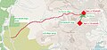
 Bla bheinn eastern side trail.jpg 1,128 × 501; 74 KB
-
 Bla bheinn south side trail.jpg 642 × 517; 69 KB
-
 Bruach na frithe trails.jpg 822 × 997; 160 KB
-
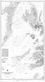 Chart 3674 Southern Approaches to the Minch Scotland.jpg 3,987 × 7,238; 4.72 MB
-
 Highland UK parish map (blank).svg 1,320 × 1,424; 3.93 MB
-
 Isle of Skye UK blank map.svg 1,334 × 1,424; 1.39 MB
-
 Isle of Skye UK location map.svg 1,334 × 1,424; 1.56 MB
-
 Isle of Skye UK relief location map labels.jpg 2,004 × 2,137; 867 KB
-
 Isle of Skye UK relief location map.jpg 2,004 × 2,137; 462 KB
-
 Skye - Skye and the Small Isles.svg 897 × 847; 2.81 MB
-
 Ordnance Survey One-Inch Sheet 24 North Skye, Published 1957.jpg 8,246 × 9,883; 8.02 MB
-
 Ordnance Survey One-Inch Sheet 25 Portree, Published 1956.jpg 8,271 × 9,868; 8.63 MB
-
 Ordnance Survey One-Inch Sheet 25 Raasay & Applecross, Published 1947.jpg 10,459 × 12,911; 11.33 MB
-
 Ordnance Survey One-Inch Sheet 33 Rhum and part of Skye, Published 1957.jpg 8,263 × 9,746; 6.63 MB
-
 Ordnance Survey One-Inch Sheet 34 South Skye and Arisaig, Published 1957.jpg 8,210 × 9,880; 7.19 MB
-
 Ordnance Survey One-Inch Sheet 35 Sound of Sleat, Published 1947.jpg 8,186 × 10,443; 9.59 MB
-
 Ordnance Survey Quarter-inch sheet 4 Western Highlands, published 1967.jpg 9,627 × 8,869; 8.85 MB
-
 Ordnance Survey Sheet NG 24 34 Dunvegan, Published 1971.jpg 14,695 × 6,915; 25.24 MB
-
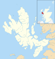
 Raasay.png 433 × 427; 14 KB
-
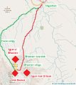
 Sgurr a' mhadaidh sgurr a greadaidh trails.jpg 1,060 × 492; 181 KB
-
 Sgurr Alasdair1.jpg 948 × 582; 227 KB
-
 Sgurr dearg.jpg 1,322 × 534; 203 KB
-
 Sgurr dubh mor1.jpg 1,089 × 494; 243 KB
-
 Sgurr nan eag sgurr dubh mor.jpg 1,296 × 491; 210 KB
-
 Sgurr nan gillean.jpg 413 × 542; 65 KB
-
 Skye map.PNG 433 × 427; 22 KB
-
 Skye parish map.jpg 407 × 562; 36 KB
-
 Skye talisker.png 1,024 × 768; 33 KB
-
 Skye, Lochaber and Badenoch (Scottish Parliament constituency).svg 691 × 1,020; 456 KB
-
 Skye.png 283 × 292; 8 KB
-
 The Quarterly journal of the Geological Society of London (12826668154).jpg 1,797 × 1,079; 493 KB
-
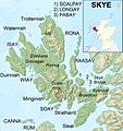
 UK Skye.PNG 648 × 584; 20 KB
%27_(11245177623).jpg)


.jpg)


.svg)

.jpg)

.svg)