Category:Maps of the Islamic conquests
Jump to navigation
Jump to search
Subcategories
This category has only the following subcategory.
M
- Maps of the Arab–Byzantine wars (58 F)
Media in category "Maps of the Islamic conquests"
The following 37 files are in this category, out of 37 total.
-

-
 A history of mediaeval and modern Europe for secondary schools (1914) (14781280651).jpg 1,840 × 1,308; 465 KB
-
 Amitchel125 Early Muslim Conquests Map Markup.png 1,645 × 998; 672 KB
-
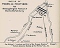 Battle of Tours 932-map.jpg 700 × 560; 30 KB
-
 Expansion of Islam (Atlas of European history, 1909).PNG 1,218 × 842; 1.17 MB
-
 First Fitna Map, Ali-Muawiya Phase.png 1,572 × 1,320; 327 KB
-
 Invasionislámicaespaña.svg 673 × 692; 1.51 MB
-
 Iran-arab invasion.jpg 3,803 × 3,129; 2.23 MB
-
 Islam's Mediterranean.jpg 2,187 × 1,550; 1.02 MB
-
 Islamic Campaign to Sindh in 39 H.png 1,241 × 819; 1.5 MB
-
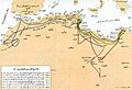
 Islamic expansion in France in the 8th century-ar.jpg 565 × 539; 213 KB
-
 Islamic expansion in France in the 8th century.jpg 565 × 539; 78 KB
-
 Khalid ibn al-Walid's Desert March to Syria, ca. April 634.png 1,266 × 1,057; 825 KB
-
 Khalid ibn al-Walid's Ridda campaign.png 1,515 × 1,021; 808 KB
-
 Map of Amr's Conquests.png 7,025 × 4,439; 75.62 MB
-
 Mohammad adil-Khalid's conquest of Iraq-es.svg 1,531 × 1,128; 278 KB
-
 Mohammad adil-Khalid's conquest of Iraq-pt.svg 1,531 × 1,128; 23 KB
-
 Mohammad adil-Khalid's conquest of Iraq.PNG 1,531 × 1,128; 118 KB
-
 Mohammad adil-Muslim invasion of Syria-3-pt.svg 1,367 × 1,520; 50 KB
-
 Muslim conquest of the Maghreb.png 3,742 × 1,247; 927 KB
-
 Muslim-Byzantine troop movement (635-636)-ar.png 1,282 × 1,580; 314 KB
-
 Muslim-Byzantine troop movement (635-636)-zh.svg 1,512 × 1,895; 327 KB
-
 Old Arab World map (old Russian).jpg 569 × 341; 75 KB
-
 Second Fitna Battle Map.png 1,310 × 1,110; 973 KB
-
 Syria toward end of Muslim conquest, c. 638.png 943 × 1,142; 1.11 MB
-
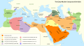 The Early Muslim Conquests 630s to 820s.svg 943 × 515; 1.09 MB
-
 النشاط الإسلامي في البحر المتوسط بين القرنين السابع والتاسع الميلاديين.jpg 1,932 × 1,372; 803 KB
-
 خريطة الدول الإسلامية في العصرين الأموي والعباسي.jpg 3,644 × 2,068; 1.27 MB
-
 فتح ما وراء النهر.png 2,048 × 1,598; 4.23 MB
-
 فتوح المسلمين في صقلية وجنوب إيطاليا.jpg 1,257 × 862; 319 KB
-
 فتوح المغرب 2.jpg 935 × 630; 214 KB
-
 فتوح المغرب.jpg 929 × 634; 234 KB
-
 فتوح قتيبة بن مسلم ومحمد بن القاسم.jpg 669 × 975; 234 KB
-
 فتوحات إفريقية والمغرب في عهد عبد الملك بن مروان.jpg 777 × 484; 144 KB
-
 فتوحات حبيب بن مسلمة في أرمينية.png 644 × 566; 341 KB
-
 نشاط المسلمين البحري في الحوض الأوسط للبحر المتوسط.jpg 671 × 971; 199 KB
-
 نشاط المسلمين البحري في الحوض الغربي للبحر المتوسط.jpg 969 × 679; 221 KB
%27_(11043140065).jpg)
_(14781280651).jpg)


.PNG)


-ar.png)
-zh.svg)
.jpg)


