Category:Maps of the Indian Territory
Jump to navigation
Jump to search
Maps of the Indian Territory
Subcategories
This category has only the following subcategory.
A
Media in category "Maps of the Indian Territory"
The following 132 files are in this category, out of 132 total.
-

-
 Map of Indian territory 1836.png 7,477 × 9,136; 92.32 MB
-
 1883 Indian Territory, by S. Augustus Mitchell, from the Digital Commonwealth.jpg 8,796 × 6,929; 105.84 MB
-
 IndianTerritory1885.jpg 1,321 × 1,000; 413 KB
-

-
 Okterritory.png 2,515 × 1,500; 534 KB
-
 IndianTerritory.jpg 1,000 × 1,061; 233 KB
-
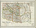
 US-MAPS(1891) p504 - MAP OF TEXAS, OKLAHOMA AND INDIAN TERRITORY (l).jpg 2,160 × 1,504; 1.01 MB
-
 1893 Poor's Mexican Central Railway.jpg 4,074 × 2,612; 1.71 MB
-
 Charles Fitch Map.png 357 × 406; 224 KB
-
 1903 Poor's Southern Pacific Company Atlantic System.jpg 3,278 × 2,130; 1.92 MB
-
-

-
 Additional Right of Way Connections Bridge C449 & C450 M.L. - NARA - 6093226.jpg 4,000 × 1,224; 517 KB
-

-

-

-

-

-

-

-

-

-

-

-

-

-

-

-

-

-

-
 Annual Reports of the Department of the Interior 1905 (1905) (14784356812).jpg 3,234 × 4,554; 2.37 MB
-
 Arbuckle Bros. Coffee Company (3093816184).jpg 799 × 489; 351 KB
-
 Arkansasterritory.PNG 453 × 206; 14 KB
-

-

-
 Boundaries of the Five Tribes in 1866.svg 800 × 395; 2.46 MB
-
 Cherokee Outlet 1885.jpg 400 × 302; 41 KB
-
 EB9 Indian Territory.jpg 1,302 × 1,013; 254 KB
-
 EB9 Texas.jpg 3,886 × 5,413; 3.49 MB
-
 EB9 United States - historical maps (bottom).jpg 2,501 × 2,000; 942 KB
-
 Former Indian Reservations in Oklahoma.jpg 1,240 × 726; 99 KB
-

-

-

-
 FT. Smith & Western R.R. Plat Showing Station Grounds at Kinta I.T. - NARA - 6092936.jpg 4,000 × 3,841; 2.03 MB
-

-
 General Map of Sulphur Springs, Indian Territory, North of Base Line - NARA - 6093502.jpg 4,000 × 2,977; 1.67 MB
-
 Gray's new map of Texas and Indian Territory.jpg 597 × 370; 75 KB
-

-

-

-

-

-

-

-

-

-

-

-

-

-

-

-

-

-

-

-

-

-

-

-

-
 Hatsburg Indian Territory.jpg 447 × 225; 42 KB
-

-
 Incorporated Town of Hartshorn, Choctaw Nation, Indian Territory - NARA - 6093684.jpg 4,000 × 2,885; 2.18 MB
-
 Indian territory (NBY 15522).jpg 3,600 × 2,829; 2.31 MB
-
 Indian Territory - Kansas, Nebraska, Dakota and Montana - NARA - 102278808.jpg 5,156 × 6,458; 2.6 MB
-
 Indian Territory - NARA - 112061614.jpg 10,356 × 8,259; 5.68 MB
-

-

-

-
 Indian Territory with part of the adjoining state of Kansas - NARA - 139308988.jpg 8,472 × 6,742; 2.55 MB
-
 Indian Territory with Parts of Neighboring States and Territories - NARA - 103396854.jpg 11,712 × 8,104; 5.88 MB
-
 Indian Territory with Parts of Neighboring States and Territories - NARA - 139308990.jpg 11,756 × 8,020; 15.61 MB
-
 Indian Territory, with part of the adjoining state of Kansas, etc. LOC 2011590003.jpg 10,770 × 8,148; 9.29 MB
-
 Iowa 1905 Census Map Indian Terr Accessions.jpg 1,351 × 908; 1.01 MB
-

-

-

-

-

-

-

-
 M. K. and O. R. R. Location Map. Cherokee Nation I.T. - NARA - 6092879.jpg 1,221 × 4,000; 463 KB
-

-

-
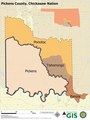 Map of Pickens County Chickasaw Nation.pdf 5,400 × 7,200; 4.05 MB
-

-

-

-

-
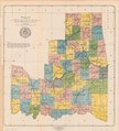
 Map of the Indian and Oklahoma Territories 1892.jpg 1,221 × 900; 368 KB
-
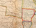
 Map of the Republic of Texas and the Adjacent Territories, 1841.jpg 1,437 × 1,212; 458 KB
-

-

-

-

-

-

-

-

-

-

-

-

-

-
-
 NIE 1905 Oklahoma.jpg 2,570 × 1,571; 1.41 MB
-

-
 Premier series map of Oklahoma and Indian Territory cropped.png 536 × 563; 674 KB
-
 Sequoyah map.jpg 4,390 × 4,820; 9.65 MB
-
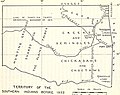
 State of Sequoyah LOC 2013592417.jpg 4,749 × 5,267; 3.46 MB
-
 State of Sequoyah LOC 2013592417.tif 4,749 × 5,267; 71.56 MB
-
 The Commercial and financial chronicle (1906) (14758913686).jpg 4,182 × 2,528; 1.3 MB
-
 The essential facts of Oklahoma history and civics (1914) (14770606281).jpg 2,984 × 2,004; 1 MB
-

-
 Trail of tears map NPS.jpg 902 × 443; 103 KB
-
 Trails of Tears en.png 2,025 × 1,547; 3.04 MB
-
 United States 1854-1858.png 1,000 × 677; 101 KB
-
 University of California publications in history (1911) (14750237496).jpg 2,940 × 2,336; 1,001 KB
.jpg)


.jpg)


_p504_-_MAP_OF_TEXAS,_OKLAHOMA_AND_INDIAN_TERRITORY_(l).jpg)


.jpg)


_(14784356812).jpg)
.jpg)

.jpg)
_(page_69_crop).jpg)


.jpg)


_-_NARA_-_6093807_(page_10).jpg)
_-_NARA_-_6093807_(page_11).jpg)
_-_NARA_-_6093807_(page_12).jpg)
_-_NARA_-_6093807_(page_13).jpg)
_-_NARA_-_6093807_(page_14).jpg)
_-_NARA_-_6093807_(page_15).jpg)
_-_NARA_-_6093807_(page_16).jpg)
_-_NARA_-_6093807_(page_17).jpg)
_-_NARA_-_6093807_(page_18).jpg)
_-_NARA_-_6093807_(page_19).jpg)
_-_NARA_-_6093807_(page_20).jpg)
_-_NARA_-_6093807_(page_21).jpg)
_-_NARA_-_6093807_(page_22).jpg)
_-_NARA_-_6093807_(page_23).jpg)
_-_NARA_-_6093807_(page_24).jpg)
_-_NARA_-_6093807_(page_1).jpg)
_-_NARA_-_6093807_(page_2).jpg)
_-_NARA_-_6093807_(page_3).jpg)
_-_NARA_-_6093807_(page_4).jpg)
_-_NARA_-_6093807_(page_5).jpg)
_-_NARA_-_6093807_(page_6).jpg)
_-_NARA_-_6093807_(page_7).jpg)
_-_NARA_-_6093807_(page_8).jpg)
_-_NARA_-_6093807_(page_9).jpg)


.jpg)


.jpg)


_-_DPLA_-_eac3e126b79333a68a8acc4302277843.jpg)
_-_DPLA_-_041c6527331f8c00139c35c02a115e14.jpg)


_review_of_the_present_condition,_industry,_and_resources_of_the_American_confederacy-_(IA_newcompletegazet00bald)_(page_4_crop).jpg)


_(14758913686).jpg)
_(14770606281).jpg)


_(14750237496).jpg)