Category:Maps of the Gulf of Naples
Jump to navigation
Jump to search
Subcategories
This category has only the following subcategory.
O
- Old maps of the Gulf of Naples (22 F)
Media in category "Maps of the Gulf of Naples"
The following 23 files are in this category, out of 23 total.
-
 Napoli map.png 798 × 622; 221 KB
-
 Admiralty Chart No 1380 Plans in the Golfo di Napoli, Published 1966.jpg 8,273 × 11,008; 10.79 MB
-
 Admiralty Chart No 3931 Golfo di Napoli, Published 1945.jpg 12,332 × 8,473; 26.36 MB
-
 Capri and Ischia map hr.svg 1,004 × 655; 275 KB
-
 Capri and Ischia map hu.png 963 × 624; 119 KB
-
 Capri and Ischia map it.PNG 971 × 634; 118 KB
-
 Capri and Ischia map mk.svg 1,004 × 655; 423 KB
-
 Capri and Ischia map-es.svg 752 × 508; 723 KB
-
 Capri and Ischia map-fr.svg 752 × 508; 599 KB
-
 Capri and ischia map-ned.png 800 × 522; 132 KB
-
 Capri and Ischia map.png 1,504 × 975; 142 KB
-
 Delle antichità di Ercolano, 1757-1779 (T. I-VII) 10023 (23098744423).jpg 5,582 × 4,997; 6.35 MB
-
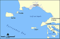
 Gulf of Naples He.jpg 942 × 794; 204 KB
-

-

-
 John Robert Cozens - Gulf of Naples Map - Google Art Project.jpg 3,653 × 1,860; 2.31 MB
-
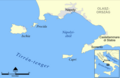
 Napoli laht.png 1,514 × 988; 154 KB
-
 Schneider Trophy 1922 Course Map.svg 48 × 37; 122 KB
-
 The description of Naples, and the territory - Moryson Fynes - 1617.jpg 1,003 × 1,451; 934 KB
-
 Vallardi - Napoli.jpg 6,395 × 4,180; 12.28 MB
-
 Vesuvius SRTM3.png 942 × 794; 922 KB
-
 Vesuvius SRTM3.xcf 942 × 794; 2.33 MB
-
 Zona rossa Vesuvio.png 942 × 794; 904 KB


_10023_(23098744423).jpg)

_(14586178510).jpg)
_(14586248829).jpg)


