Category:Maps of the Gulf of Bothnia
Jump to navigation
Jump to search
Media in category "Maps of the Gulf of Bothnia"
The following 22 files are in this category, out of 22 total.
-
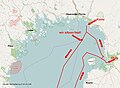 2017-03-23 Reiseroute Karte Kemi-Oulu.jpg 927 × 681; 319 KB
-
 Admiralty Chart No 2252 Gulf of Bothnia, Published 1874, Large Corrections 1905.jpg 10,903 × 16,187; 68.51 MB
-

-
 Admiralty Chart No 2297 Hango Head to South Quarken, Published 1872, Large Corrections 1908.jpg 16,273 × 10,909; 29.77 MB
-

-
 Admiralty Chart No 2301 Gulf of Bothnia Sheet 6, Published 1895.jpg 16,187 × 10,918; 55.29 MB
-
 Bottniska viken ka.png 316 × 380; 13 KB
-
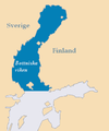 Bottniska viken.png 316 × 380; 13 KB
-
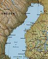
 Finland 1996 CIA map.jpg 1,662 × 2,000; 2.5 MB
-
 Golf de Bòtnia.png 316 × 380; 5 KB
-
 Gulf Bothnia - 1.jpg 843 × 1,019; 313 KB
-
 Gulf of Bothnia.jpg 1,056 × 1,448; 584 KB
-
 Gulf of Finland 1.svg 744 × 863; 15 KB
-
 Map of Finland (first half of XVIII century).jpg 7,809 × 6,731; 17.06 MB
-
 Map orkneyinga.jpg 532 × 470; 55 KB
-
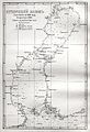
 Nagaev Atlas vsego Gulf of Bothnia.jpg 2,048 × 3,072; 3.53 MB
-
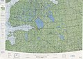
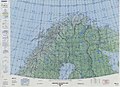 Operational Navigation Chart C-2, 13th edition.jpg 9,040 × 6,591; 18.48 MB
-
 Operational Navigation Chart D-2, 7th edition.jpg 9,254 × 6,633; 17.41 MB
-
 Operational Navigation Chart D-3, 7th edition.jpg 9,254 × 6,660; 21.89 MB
-
 Pohjanlahti1.svg 744 × 863; 45 KB
-
 The-Baltic-Sea details.png 405 × 408; 93 KB
-


.jpg)


.jpg)