Category:Maps of the Gulf of Alaska
Jump to navigation
Jump to search
Subcategories
This category has the following 2 subcategories, out of 2 total.
M
- Maps of Hubbard Glacier (6 F)
- Maps of Yakutat Bay (6 F)
Media in category "Maps of the Gulf of Alaska"
The following 10 files are in this category, out of 10 total.
-
 2018 Alaska Islands earthquake ShakeMap3.png 700 × 700; 159 KB
-
 Admiralty Chart No 2460 Kamchatka to San Francisco, Published 1942, Large Corrections 1960.jpg 17,721 × 11,259; 53.78 MB
-
 FMIB 34672 Distribution of Glacier Localities.jpeg 475 × 428; 81 KB
-
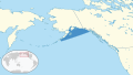 Gulf of Alaska in its region.svg 500 × 281; 4.82 MB
-
 Gulfofalaskamap.png 977 × 722; 245 KB
-
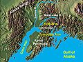
 Matanuska-Susitna Valley.jpg 300 × 280; 50 KB
-
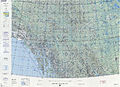
 Operational Navigation Chart D-11, 5th edition.jpg 9,254 × 6,660; 20.53 MB
-
 Operational Navigation Chart D-12, 6th edition.jpg 9,254 × 6,698; 23 MB
-
 Wpdms shdrlfi020l cook inlet with arms.jpg 300 × 226; 41 KB
-
 Wpdms shdrlfi020l matanuska river.jpg 300 × 280; 49 KB


