Category:Maps of the Ebro River
Jump to navigation
Jump to search
Media in category "Maps of the Ebro River"
The following 33 files are in this category, out of 33 total.
-
 Watershed of the Ebro-fr.png 2,994 × 2,029; 4.38 MB
-
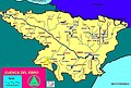
 SpainEbroBasin.png 1,751 × 1,248; 2.45 MB
-
 Watershed of the Ara-fr.png 2,994 × 2,029; 4.38 MB
-
-
 Admiralty Chart No 310 Spain east coast Cape Tortosa to Cape St Sebastian, Published 1892.jpg 13,240 × 8,336; 12.57 MB
-

-
 Cuenca del Cinca.png 800 × 542; 313 KB
-
 Cuenca del rio Piedra.jpg 800 × 542; 217 KB
-
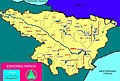
 Cuenca del Segre.png 800 × 542; 359 KB
-
 DeltaEbreCat.png 680 × 636; 84 KB
-
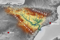
 Depresión d'Ebro.png 1,600 × 1,070; 2.62 MB
-
 CuencaDelEbrov1.svg 2,305 × 1,281; 2.22 MB
-
 Valle del Ebro.jpg 1,196 × 810; 413 KB
-
 Ebro river he map.svg 1,316 × 940; 311 KB
-
 Ebro spanien.png 771 × 507; 240 KB
-
 Ebroko harana.jpg 1,196 × 810; 491 KB
-
 Ebroko sakonunea 2.png 1,014 × 688; 970 KB
-
 Ebroko sakonunea.svg 819 × 622; 704 KB
-
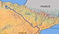 EbroSlagetvidCannae.JPG 397 × 236; 16 KB
-
 Galachodelaalfrancaimagen.gif 400 × 400; 8 KB
-
 Mequinen.jpg 400 × 410; 38 KB
-
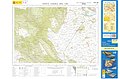 MTN25-0137c3-2011-Santa Gadea del Cid.jpg 7,874 × 5,161; 9.31 MB
-
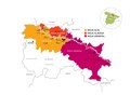 Rioja mapa regiones con Ebro Editable 2019.pdf 3,541 × 2,952; 561 KB
-
 San Andrés, Villamediana de Lomas.png 1,988 × 1,402; 1.52 MB
-
 SpanienEbro.jpg 1,316 × 940; 489 KB
-
 Valle del ebro.svg 609 × 369; 10 KB
-
 Watershed of the Aragon-fr.png 2,994 × 2,029; 4.28 MB
-
 Watershed of the Arga-fr.png 2,994 × 2,029; 4.38 MB
-
 Watershed of the Gallego-fr.png 2,994 × 2,029; 4.35 MB
-
 Watershed of the Guadalope-fr.png 2,994 × 2,029; 4.34 MB
-
 Watershed of the Irati-fr.png 2,994 × 2,029; 4.39 MB
-
 Watershed of the Jalon-fr.png 2,994 × 2,029; 4.28 MB
-
 Watershed of the Jiloca-fr.png 2,994 × 2,029; 4.36 MB


%27_(11154482636).jpg)


