Category:Maps of the East Prussian plebiscite
Jump to navigation
Jump to search
Media in category "Maps of the East Prussian plebiscite"
The following 22 files are in this category, out of 22 total.
-
 Abschnürung der Weichsel nach der Volksabstimmung 1920.jpg 778 × 1,029; 316 KB
-
 Abstimmungsergebnisse Ostpreußen 1920.JPG 2,197 × 1,389; 264 KB
-
 Abstimmungsergebnisse Ostpreußen Stimmen 1920 en.svg 850 × 700; 71 KB
-
 Abstimmungsergebnisse Ostpreußen Stimmen 1920-hu.svg 850 × 700; 74 KB
-
 Abstimmungsergebnisse Ostpreußen Stimmen 1920.svg 850 × 700; 92 KB
-
 Abstimmungsgebiet Ostpreußen.jpg 9,240 × 8,707; 89.93 MB
-
 Abstimmungsgebiet Westpreußen und Danzig.jpg 5,251 × 6,909; 40.24 MB
-
 Abstimmungsgebiete Ostpreußen Sprachen 1910 en.svg 850 × 700; 78 KB
-
 Abstimmungsgebiete Ostpreußen Sprachen 1910-hu.svg 850 × 700; 108 KB
-
 Abstimmungsgebiete Ostpreußen Sprachen 1910.svg 850 × 700; 98 KB
-
 Ethnic map East Prussia 1907.jpeg 1,682 × 2,139; 4.75 MB
-
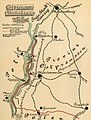
 London-geographical-institute the-peoples-atlas 1920 poland-and-the-new-baltic-states.jpg 3,012 × 3,992; 2.02 MB
-
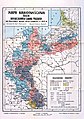 Mapa narodowosciowa 1910.jpg 3,409 × 4,833; 8.66 MB
-
 Plebiscito sulla Prussia Orientale.gif 743 × 415; 19 KB
-
 Plebiscyt na Mazurach i Warmii 2.gif 743 × 322; 13 KB
-
 Plebiscyt na Mazurach i Warmii.gif 743 × 415; 19 KB
-
 Plebiscyt na Mazurach i Warmii.PNG 743 × 415; 19 KB
-
 Plebiszit Sprache Ostpreussen 1920-en.png 1,667 × 2,894; 423 KB
-
 Plebiszit Sprache Ostpreussen 1920.png 835 × 1,343; 316 KB
-
 Plebiszit Sprache Ostpreussen 1920.svg 813 × 1,353; 86 KB
-
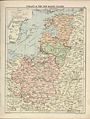
 Poland & The New Baltic States.jpg 1,376 × 1,784; 1.22 MB
-
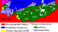
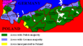
 Polska-ww1-nation.png 791 × 1,000; 560 KB


