Category:Maps of the Deepwater Horizon oil spill
Jump to navigation
Jump to search
Media in category "Maps of the Deepwater Horizon oil spill"
The following 37 files are in this category, out of 37 total.
-
 1884 cumlative4 29 trajectories.jpg 1,683 × 1,275; 199 KB
-
 BP OilSpill FisheryClosureMap 062110.pdf 1,625 × 1,281; 783 KB
-
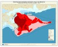
 Deepwater Horizon incident, Gulf of Mexico LOC 2010589205.jpg 10,800 × 7,200; 6.15 MB
-
 Deepwater Horizon incident, Gulf of Mexico LOC 2010589205.tif 10,800 × 7,200; 222.47 MB
-
-
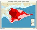
 Deepwater Horizon incident, Gulf of Mexico, forecasted oil spill location for May 1, 2010 LOC 2010589162.tif 13,200 × 10,800; 407.87 MB
-
 Deepwater Horizon Oil Spill Fishing Closure 2010-05-25.png 3,254 × 2,566; 288 KB
-
 Deepwater Horizon oil spill fishing closure map 2010-06-02.png 3,254 × 2,566; 314 KB
-
 Deepwater Horizon oil spill fishing closure map 2010-06-21.png 3,254 × 2,566; 306 KB
-
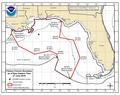
 Deepwater Horizon oil spill NOAA map.jpg 962 × 747; 370 KB
-
 DeepwaterHorizonOilSpill FishingClosure 2010-05-18.png 3,226 × 2,538; 251 KB
-
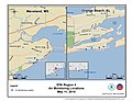
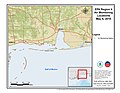
 EPA Air Monitoring Locations April 28 - May 14, 2010 (4612958117).jpg 3,300 × 2,550; 2.04 MB
-
 EPA Air Monitoring Locations May 10, 2010 (4612082200).jpg 3,300 × 2,550; 1.8 MB
-
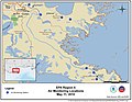
 EPA Air Monitoring Locations May 11, 2010 (4611472203).jpg 3,300 × 2,550; 1.8 MB
-
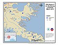
 EPA Air Monitoring Locations May 11, 2010 (4612083038).jpg 3,300 × 2,550; 2.04 MB
-
 EPA Air Monitoring Locations May 12, 2010 (4612083598).jpg 3,300 × 2,550; 1.63 MB
-
 EPA Air Monitoring Locations May 13, 2010 (4612083850).jpg 3,300 × 2,550; 1.78 MB
-
 EPA Air Monitoring Locations May 13-14, 2010 (4611473283).jpg 3,300 × 2,550; 2.02 MB
-
 EPA Air Monitoring Locations May 4, 2010 (4611469093).jpg 3,300 × 2,550; 1.43 MB
-
 EPA Air Monitoring Locations May 4, 2010 (4611469787).jpg 3,300 × 2,550; 1.46 MB
-
 EPA Air Monitoring Locations May 5, 2010 (4612080288).jpg 3,300 × 2,550; 1.44 MB
-
 EPA Air Monitoring Locations May 6, 2010 (4611469357).jpg 3,300 × 2,550; 1.8 MB
-
 EPA Air Monitoring Locations May 7, 2010 (4611469521).jpg 3,300 × 2,550; 1.49 MB
-
 EPA Air Monitoring Locations May 7, 2010 (4612080512).jpg 3,300 × 2,550; 1.45 MB
-
 EPA Air Monitoring Locations May 9, 2010 (4611470407).jpg 3,300 × 2,550; 1.63 MB
-
 EPA Air Monitoring Locations May 9, 2010 (4611470671).jpg 3,300 × 2,550; 1.92 MB
-
 EPA Air Sampling Locations May 1, 2010 (4612081156).jpg 3,300 × 2,550; 1.96 MB
-
 EPA Air Sampling Locations May 1-2, 2010 (4612081278).jpg 3,300 × 2,550; 1.94 MB
-
 EPA Air Sampling Locations May 2, 2010 (4612081362).jpg 3,300 × 2,550; 1.82 MB
-
 EPA Air Sampling Locations May 3-4, 2010 (4611472727).jpg 3,300 × 2,550; 2.23 MB
-
 EPA Air Sampling Locations May 4-5, 2010 (4611470325).jpg 3,300 × 2,550; 1.96 MB
-
 EPA Air Sampling Locations May 4-7, 2010 (4612083214).jpg 3,300 × 2,550; 2.05 MB
-
 EPA Air Sampling Locations May 5, 2010 (4612084278).jpg 3,300 × 2,550; 2.25 MB
-
 EPA Air Sampling Locations May 6-8, 2010 (4612957763).jpg 3,300 × 2,550; 2.47 MB
-
 EPA Air Sampling Locations May 8-10, 2010 (4611473093).jpg 3,300 × 2,550; 2.84 MB
-
 EPA Water Sampling Locations May 1-3, 2010 (4612081608).jpg 3,300 × 2,550; 2.01 MB
-
 Noaa-projection-deepwater.png 528 × 408; 63 KB


.jpg)
.jpg)
.jpg)
.jpg)
.jpg)
.jpg)
.jpg)
.jpg)
.jpg)
.jpg)
.jpg)
.jpg)
.jpg)
.jpg)
.jpg)
.jpg)
.jpg)
.jpg)
.jpg)
.jpg)
.jpg)
.jpg)
.jpg)
.jpg)
.jpg)
