Category:Maps of the Borough of Halton
Jump to navigation
Jump to search
Media in category "Maps of the Borough of Halton"
The following 12 files are in this category, out of 12 total.
-
 EnglandHalton.png 200 × 247; 25 KB
-
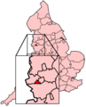
 Halton in England (special marker).svg 816 × 991; 1.32 MB
-
 Halton in England (zoom).svg 816 × 991; 1.33 MB
-
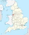
 Halton in England.svg 816 × 991; 1.32 MB
-
 Halton UK local election 2018 map.svg 1,425 × 1,129; 302 KB
-
 Halton UK locator map.svg 1,425 × 1,098; 999 KB
-
 Halton UK ward map 2010 (blank).svg 1,425 × 1,129; 301 KB
-
 Halton unparished area UK locator map.svg 1,425 × 1,129; 233 KB
-
 River Mersey map.png 1,403 × 571; 1.18 MB
-
 Runcorn Cheshire map (railways).png 1,000 × 699; 477 KB
-
 Runcorn Cheshire map.png 1,000 × 704; 332 KB
-
 Ship canal map.png 4,678 × 2,224; 759 KB

.svg)
.svg)


.png)


.svg)